
Lee County topographic map
Click on the map to display elevation.
Lee County
Lee County features a predominantly flat topography with minimal elevation variation. The average elevation across the county ranges from sea level up to approximately 30 feet in some inland areas like Lehigh Acres. The region is characterized by extensive wetlands, marshes, and a network of rivers and estuaries, which contribute to its rich biodiversity. Coastal areas, including islands such as Sanibel and Captiva, showcase sandy beaches that gently slope into the Gulf of Mexico. Overall, the terrain is relatively low-lying, making it vulnerable to flooding, particularly during heavy rainstorms or hurricanes.
About this map
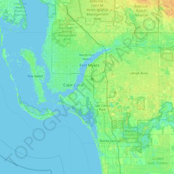
Name: Lee County topographic map, elevation, terrain.
Location: Lee County, Florida, United States (26.31613 -82.33504 26.78955 -81.56218)
Average elevation: 16 ft
Minimum elevation: -7 ft
Maximum elevation: 79 ft
Florida trails, hiking, mountain biking, running and outdoor activities
Other topographic maps
Click on a map to view its topography, its elevation and its terrain.
Parrish
United States > Florida > Manatee County
Parrish features a predominantly flat terrain with an average elevation of approximately 36 feet above sea level. The area's landscape is characterized by gently rolling hills and low-lying regions, making it typical of the Central Florida topography. Surrounding Parrish are numerous wetlands and drainage…
Average elevation: 39 ft
Navarre
United States > Florida > Santa Rosa County
Navarre is located at 30°24′04″N 86°51′47″W / 30.401°N 86.863°W / 30.401; -86.863Coordinates: 30°24′04″N 86°51′47″W / 30.401°N 86.863°W / 30.401; -86.863. It is located within a portion of the Florida Panhandle observing the Central Time Zone. Elevation is at an average of 10 feet (3.0 m).
Average elevation: 13 ft
Palm Harbor
United States > Florida > Pinellas County
Palm Harbor is characterized by its unique topography, which features a relatively rare hilly landscape for the region. Unlike much of the surrounding areas in Pinellas County, which are predominantly flat, Palm Harbor includes elevations that can reach up to about 75 feet above sea level. This elevation gives…
Average elevation: 30 ft
Port Charlotte
United States > Florida > Charlotte County
Port Charlotte is characterized by a predominantly flat and low-lying terrain, typical of Florida’s coastal landscape. The area features a network of waterways, including the Peace River and Charlotte Harbor, which provide ample opportunities for recreational activities like boating and fishing. Elevations…
Average elevation: 13 ft
Nokomis
United States > Florida > Sarasota County
Nokomis features a predominantly flat and low-lying terrain characteristic of the coastal region. The elevation in Nokomis rarely exceeds 15 feet above sea level, contributing to its vulnerability to tidal influences and storm surges. The area is interspersed with wetlands and mangroves, particularly near the…
Average elevation: 16 ft
Anna Maria island
United States > Florida > Manatee County
Anna Maria Island features a flat, sandy topography typical of a barrier island on the Gulf Coast. With an average elevation of around 15 feet above sea level, the terrain includes broad beaches, low dunes, and narrow stretches of sandy soil, making it highly vulnerable to storm surges and tidal flooding. The…
Average elevation: 7 ft
Florida Keys
United States > Florida > Monroe County
Tropical cyclones present special dangers and challenges to the entire Keys. Because no area of the islands is more than 20 feet (6.1 m) above sea level (and many are only a few feet elevation), and water surrounds the islands, nearly every neighborhood is subject to flooding as well as hurricane winds. In…
Average elevation: 0 ft
Jacksonville
United States > Florida > Duval County > Jacksonville
Just south of Jacksonville and north of Saint Augustine is the boundary of where the Floridian Peninsula ends and Continental North America begins; Jacksonville is north of that line. While still in the North American Coastal plain, the topography begins to take on slight Piedmont characteristics. Like the…
Average elevation: 30 ft
Butler Beach
United States > Florida > Saint Johns County > Saint Augustine Beach
Average elevation: 7 ft
Ponte Vedra Beach
United States > Florida > Saint Johns County > Ponte Vedra Beach
Ponte Vedra Beach is characterized by its gently rolling terrain that is primarily flat and lies only about 15 feet above sea level. The landscape is predominantly shaped by coastal dunes and the proximity to the Atlantic Ocean, resulting in sandy beaches interspersed with vegetation typical of barrier island…
Average elevation: 10 ft
Lutz
United States > Florida > Hillsborough County > Tampa
Lutz is characterized by a gently rolling topography that showcases the distinctive features of the central Florida landscape. The area has an average elevation of about 70 feet (21 meters) above sea level, contributing to its mild undulations rather than dramatic elevation changes. The terrain is marked by a…
Average elevation: 66 ft
Englewood
United States > Florida > Sarasota County > Englewood
Englewood features predominantly flat and low-lying terrain typical of the region's coastal landscape. The average elevation here is approximately 15 feet above sea level, which makes the area particularly susceptible to tidal influences and storm surges. The terrain is interspersed with wetlands and…
Average elevation: 10 ft
Orlando
United States > Florida > Orange County
According to the Köppen climate classification, Orlando has a humid subtropical climate (Cfa) like much of the deep Southern United States. The two basic seasons in Orlando are a hot and rainy season, lasting from May until late October (roughly coinciding with the Atlantic hurricane season), and a warm and…
Average elevation: 95 ft
Shady Oaks Trailer Park
United States > Florida > Miami-Dade County > North Miami
Average elevation: 30 ft
Key Biscayne
United States > Florida > Miami-Dade County
Key Biscayne lies south of Miami Beach and east of Miami. The village is connected to Miami via the Rickenbacker Causeway, originally built in 1947. Because of its low elevation and direct exposure to the Atlantic Ocean, it is usually among the first Miami areas to be evacuated before an oncoming hurricane.
Average elevation: 10 ft
Myakka City
United States > Florida > Manatee County
Myakka City (also Myakka) is an unincorporated community in southeastern Manatee County, Florida, United States. It lies along State Road 70 near the city of Bradenton, the county seat of Manatee County. Its elevation is 43 feet (13 m), and it is located at 27°20′59″N 82°9′41″W / 27.34972°N…
Average elevation: 46 ft
Miccosukee
United States > Florida > Leon County
By 1858, perhaps 200 ancestors of the modern Miccosukee and Seminole Tribes remained in Florida. They survived by moving into central and southern Florida to take advantage of the topography of Big Cypress and the Everglades, which was largely unknown to the remainder of the U.S. The American Civil War during…
Average elevation: 194 ft
The Lil' Saint John's River
United States > Florida > Duval County > Jacksonville Beach
Average elevation: 10 ft
Shangri-La Mobile Home Park
United States > Florida > Lee County > Saint James City
Average elevation: 3 ft
Lauderdale Harbors
United States > Florida > Broward County > Fort Lauderdale
Average elevation: 20 ft
Jensen Beach
United States > Florida > Martin County
The Skyline Drive area includes some of the highest points in the community, reaching an elevation of 70 feet (21 m) at one point.
Average elevation: 16 ft
Whispering Hills Golf Estates
United States > Florida > Brevard County > Titusville
Average elevation: 20 ft
Spring Lake
United States > Florida > Hernando County
Spring Lake contains rolling hills ranging in elevation from 120ft to 280ft.
Average elevation: 161 ft