Geolocate

Devils Lake topographic map

Click on the map to display elevation.

About this map

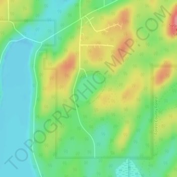
Name: Devils Lake topographic map, elevation, terrain.

Location: Devils Lake, Town of Lincoln, Forest County, Wisconsin, United States (45.54554 -88.83609 45.54948 -88.83090)

Average elevation: 1,752 ft

Minimum elevation: 1,631 ft

Maximum elevation: 1,946 ft

Wisconsin trails, hiking, mountain biking, running and outdoor activities

Other topographic maps

Click on a map to view its topography, its elevation and its terrain.

Columbia County

United States > Wisconsin

Average elevation: 912 ft

Lake Winnebago

United States > Wisconsin

A system of seventeen locks connects Lake Winnebago to Lake Michigan at Green Bay, an elevation drop of about 150 feet (45 m). This lock system is located along the lower Fox River and starts at the northwest corner of Lake Winnebago in the city of Menasha and ends at the mouth of Green Bay. One of the locks,…

Average elevation: 833 ft

Manitowoc

United States > Wisconsin > Manitowoc County

Average elevation: 627 ft

Town of Seneca

United States > Wisconsin > Crawford County

Average elevation: 981 ft

Fox River

United States > Wisconsin

Average elevation: 892 ft

Brule River State Forest

United States > Wisconsin

Average elevation: 1,050 ft

Niagara

United States > Wisconsin > Marinette County

Average elevation: 1,020 ft

La Crosse County

United States > Wisconsin

Average elevation: 902 ft

Jefferson

United States > Wisconsin > Jefferson County

Jefferson's elevation is 797 ft (243 m) at the center of downtown.

Average elevation: 823 ft

Delavan Lake

United States > Wisconsin > Walworth County

Average elevation: 965 ft

Madison

United States > Wisconsin > Dane County

The city is sometimes described as The City of Four Lakes, comprising the four successive lakes of the Yahara River: Lake Mendota ("Fourth Lake"), Lake Monona ("Third Lake"), Lake Waubesa ("Second Lake") and Lake Kegonsa ("First Lake"), although Waubesa and Kegonsa are not actually in Madison, but just south…

Average elevation: 948 ft

Milwaukee

United States > Wisconsin > Milwaukee County > Milwaukee

Average elevation: 679 ft

Town of Evergreen

United States > Wisconsin > Langlade County

Average elevation: 1,401 ft

Aniwa

United States > Wisconsin > Shawano County

Average elevation: 1,407 ft

Colby

United States > Wisconsin > Clark County

Average elevation: 1,362 ft

Eau Claire County

United States > Wisconsin

Average elevation: 997 ft

Iowa County

United States > Wisconsin

Average elevation: 994 ft

Bald Bluff

United States > Wisconsin

Average elevation: 1,056 ft

Town of Amberg

United States > Wisconsin

Average elevation: 843 ft

Town of Ojibwa

United States > Wisconsin

Average elevation: 1,371 ft

High Falls Reservoir

United States > Wisconsin

Average elevation: 932 ft

Town of Auburn

United States > Wisconsin

Average elevation: 1,102 ft

Town of Auburn

United States > Wisconsin

Average elevation: 1,001 ft

Town of Willow Springs

United States > Wisconsin

Average elevation: 974 ft

Town of Leeds

United States > Wisconsin

Average elevation: 1,027 ft

Ashland

United States > Wisconsin

Average elevation: 1,260 ft

Town of Bloomer

United States > Wisconsin

Average elevation: 1,066 ft

Douglas County

United States > Wisconsin

Average elevation: 1,040 ft

Rock River

United States > Wisconsin

Average elevation: 830 ft

Brown County

United States > Wisconsin

Average elevation: 741 ft

Pierce County

United States > Wisconsin

Average elevation: 1,010 ft

Washington

United States > Wisconsin

Average elevation: 794 ft

Chippewa County

United States > Wisconsin

Average elevation: 1,053 ft

Taylor County

United States > Wisconsin

Average elevation: 1,381 ft

Marquette County

United States > Wisconsin

According to the U.S. Census Bureau, the county has a total area of 464 square miles (1,200 km2), of which 456 square miles (1,180 km2) is land and 8.7 square miles (23 km2) (1.9%) is water. The Mecan River, Buffalo Lake, and Puckaway Lake lie within Marquette County. The highest altitude in the county is a…

Average elevation: 850 ft

Lafayette County

United States > Wisconsin

Average elevation: 971 ft

Apostle Islands

United States > Wisconsin

Average elevation: 646 ft

Walworth

United States > Wisconsin

Average elevation: 817 ft

Town of Grafton

United States > Wisconsin > Ozaukee County

Average elevation: 666 ft

Chippewa River

United States > Wisconsin

Average elevation: 1,161 ft

Lake Wisconsin

United States > Wisconsin > Columbia County

Average elevation: 794 ft

West Jacksonport

United States > Wisconsin > Door County

Average elevation: 702 ft

Fish Creek

United States > Wisconsin > Door County

Average elevation: 620 ft

Fond du Lac

United States > Wisconsin > Fond du Lac County

Average elevation: 915 ft

Jim Falls

United States > Wisconsin > Chippewa County

Average elevation: 974 ft

Phillips

United States > Wisconsin > Price County

Average elevation: 1,463 ft

Lodi

United States > Wisconsin > Columbia County

Average elevation: 883 ft

Wittenberg

United States > Wisconsin > Shawano County

Average elevation: 1,178 ft

Town of Chetek

United States > Wisconsin > Barron County

Average elevation: 1,099 ft

Sheboygan

United States > Wisconsin > Sheboygan County > Sheboygan

Average elevation: 617 ft

Eagle River

United States > Wisconsin > Vilas County

Average elevation: 1,640 ft

Pittsfield

United States > Wisconsin > Shawano County

Average elevation: 804 ft

Monona

United States > Wisconsin > Dane County

Average elevation: 866 ft

Kaukauna

United States > Wisconsin > Outagamie County

Average elevation: 709 ft

Rib Mountain

United States > Wisconsin > Marathon County

Average elevation: 1,247 ft

Randall

United States > Wisconsin > Burnett County

Average elevation: 892 ft

Town of Randall

United States > Wisconsin > Kenosha County

Average elevation: 850 ft

Newport State Park

United States > Wisconsin > Door County

Average elevation: 597 ft

Fence

United States > Wisconsin > Florence County

Average elevation: 1,503 ft

Suamico

United States > Wisconsin > Brown County

Average elevation: 614 ft

Town of Ashippun

United States > Wisconsin > Dodge County

Average elevation: 948 ft

Rib Falls

United States > Wisconsin > Marathon County

Average elevation: 1,293 ft

Augusta

United States > Wisconsin > Eau Claire County

Average elevation: 991 ft

Little Round Lake

United States > Wisconsin > Sawyer County

Average elevation: 1,348 ft

Browns Lake

United States > Wisconsin > Racine County

Average elevation: 787 ft

Balsam Lake

United States > Wisconsin > Polk County

Average elevation: 1,161 ft

Legend Lake

United States > Wisconsin > Menominee County

Average elevation: 873 ft

Lake Hallie

United States > Wisconsin > Chippewa County

Average elevation: 912 ft

Ashwaubenon

United States > Wisconsin > Brown County

Average elevation: 623 ft

Fall River

United States > Wisconsin > Columbia County

Average elevation: 873 ft

Fennimore

United States > Wisconsin > Grant County

Average elevation: 1,158 ft

King

United States > Wisconsin > Waupaca County

Average elevation: 912 ft

Town of Salem

United States > Wisconsin > Pierce County

Average elevation: 991 ft

Town of Butler

United States > Wisconsin > Clark County

Average elevation: 1,056 ft

Rothschild

United States > Wisconsin > Marathon County

Average elevation: 1,204 ft

Seymour

United States > Wisconsin > Outagamie County

Average elevation: 810 ft

Rest Lake

United States > Wisconsin > Vilas County

Average elevation: 1,614 ft

River Hills

United States > Wisconsin > Milwaukee County

Average elevation: 686 ft

Mellen

United States > Wisconsin > Ashland County

Average elevation: 1,296 ft

La Pointe

United States > Wisconsin > Ashland County

Average elevation: 610 ft

Highbridge

United States > Wisconsin > Ashland County

Average elevation: 968 ft

Glidden

United States > Wisconsin > Ashland County

Average elevation: 1,535 ft

Lake Camelot

United States > Wisconsin > Adams County

Average elevation: 1,024 ft

Lake Sherwood

United States > Wisconsin > Adams County

Average elevation: 1,010 ft

Easton

United States > Wisconsin > Adams County

Average elevation: 942 ft

Adams

United States > Wisconsin > Adams County

Average elevation: 968 ft

Town of Wescott

United States > Wisconsin > Shawano County

Average elevation: 837 ft

Monroe

United States > Wisconsin > Green County

Average elevation: 1,024 ft

Danbury

United States > Wisconsin > Burnett County

Danbury is located at 46.006N. The longitude is -92.371W. It is in the Central Standard Time Zone. The elevation is 938 feet (286 m) above sea level.

Average elevation: 942 ft

Greenleaf

United States > Wisconsin > Brown County

Average elevation: 741 ft

Gear up for your next adventure:

🥾Hiking Shoes - Durable and comfortable shoes for trail hiking
🧣Hiking Neck Gaiter - Multi‑use neck protection for outdoor weather
🛡️Bear Spray Outdoor - Protection in bear country hikes
🪶Camp Gear Gift Set - Perfect gift bundle for outdoor fans
📡Handheld GPS Device - Reliable handheld GPS for outdoor navigation

As an Amazon Associate, this site earns from qualifying purchases at no extra cost to you.