
Perry County topographic map
Interactive map
Click on the map to display elevation.
Perry County
The County's topography is mainly flat with some rolling hills. The part of the County's eastern border, the part shared with Franklin County, is formed by the Little Muddy River. Beaucoup Creek runs north to south through the County and lies just east of Pinckneyville.
About this map
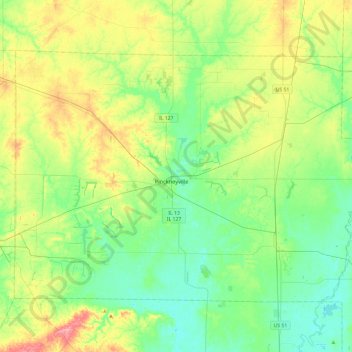
Name: Perry County topographic map, elevation, terrain.
Location: Perry County, Illinois, United States (37.95139 -89.59582 38.22035 -89.11852)
Average elevation: 469 ft
Minimum elevation: 367 ft
Maximum elevation: 692 ft
Illinois trails, hiking, mountain biking, running and outdoor activities
Other topographic maps
Click on a map to view its topography, its elevation and its terrain.
Sand Lake
United States > Illinois > Lake County > Lindenhurst > Venetian Village
Average elevation: 787 ft
West Frankfort
United States > Illinois > Franklin County
The area of West Frankfort formerly known as Frankfort is still sometimes referred to locally as Frankfort Heights or, more commonly, simply as "The Heights", due to its higher elevation relative to the rest of the city. A post office was maintained in Frankfort Heights until its destruction by fire in 2004,…
Average elevation: 400 ft