
Wilkes County topographic map
Interactive map
Click on the map to display elevation.
Wilkes County
Wilkes County is located on the eastern slope of the Blue Ridge Mountains, a part of the Appalachian Mountains chain. The county's elevation ranges from 900 feet (375 meters) in the east to over 4,000 feet (1,219 meters) in the west. The Blue Ridge Mountains run from the southwest to the northeast, and dominate the county's western and northern horizons. Tomkins Knob, the highest point in the county, rises to 4,079 feet (1243 meters). The Blue Ridge Parkway runs along the crest of the Blue Ridge on the county's northern and western borders. The foothills and valleys of the Blue Ridge form most of the county's midsection, with some elevations exceeding 2,000 feet (610 meters). Stone Mountain State Park, located in the foothills of northern Wilkes County, is one of the most popular state parks in North Carolina, and is noted for its excellent rock climbing and trout fishing. The Brushy Mountains, an isolated spur of the Blue Ridge, form the county's southern border. Wilkes County's terrain gradually becomes more level and less hilly as one moves to the east; the far eastern section of the county lies within the Piedmont region of North Carolina. The largest river in Wilkes is the Yadkin River, which flows through the central part of the county. The county's three other major streams, all of which flow into the Yadkin, are the Reddies River, Roaring River, and Mulberry Creek. Following the devastating floods of 1916 and 1940, the US Army's Corps of Engineers constructed the W. Kerr Scott Dam and Reservoir on the Yadkin River four miles west of Wilkesboro. Opened in 1962, the dam created a lake with a shoreline of 56 miles. The lake is used for boating, swimming, fishing, and waterskiing; it is especially noted for its excellent bass fishing. The W. Kerr Scott lake is the largest body of water in Wilkes.
About this map
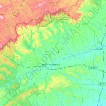
Name: Wilkes County topographic map, elevation, terrain.
Location: Wilkes County, North Carolina, United States (35.99484 -81.54549 36.44078 -80.86875)
Average elevation: 1,683 ft
Minimum elevation: 814 ft
Maximum elevation: 4,577 ft
North Carolina trails, hiking, mountain biking, running and outdoor activities
Other topographic maps
Click on a map to view its topography, its elevation and its terrain.
Appalachian Mountains
United States > North Carolina > Yancey County
The Appalachian Mountains (French: Appalaches), often called the Appalachians, are a system of mountains in eastern to northeastern North America. The Appalachians first formed roughly 480 million years ago during the Ordovician Period. They once reached elevations similar to those of the Alps and the Rocky…
Average elevation: 4,800 ft
Highlands
United States > North Carolina > Macon County > Highlands
Highlands was founded in 1875 after its two founders, Samuel Truman Kelsey and Clinton Carter Hutchinson, drew lines from Chicago to Savannah and from New Orleans to New York City. They felt that the place where these lines met would eventually become a great trading center and commercial crossroads. Highlands…
Average elevation: 3,576 ft
Loch Lommond
United States > North Carolina > Cumberland County > Fayetteville
Average elevation: 230 ft
Shadowlawn
United States > North Carolina > Cumberland County > Fayetteville
Average elevation: 187 ft
Country Club Estates
United States > North Carolina > Alamance County > Burlington
Average elevation: 640 ft
Ballantyne's Backyard
United States > North Carolina > Mecklenburg County > Charlotte
Average elevation: 600 ft
Hoopers Creek
United States > North Carolina > Henderson County > Fletcher
Average elevation: 2,221 ft
Maplewood
United States > North Carolina > Richmond County > Rockingham > East Rockingham
Average elevation: 272 ft
Shadowlawn
United States > North Carolina > Cumberland County > Fayetteville
Average elevation: 187 ft
Mount Mitchell
United States > North Carolina > Yancey County
Mount Mitchell (Attakulla in Cherokee) is the highest peak of the Appalachian Mountains and the highest peak in mainland North America east of the Mississippi River. It is located near Burnsville in Yancey County, North Carolina in the Black Mountain subrange of the Appalachians about 19 miles (31 km)…
Average elevation: 5,719 ft
Appalachian Ski Mountain Dam
United States > North Carolina > Watauga County
Average elevation: 3,652 ft
Reynolda Village
United States > North Carolina > Forsyth County > Winston-Salem
Average elevation: 912 ft
Mount Mitchell
United States > North Carolina > Yancey County
Mount Mitchell, known in Cherokee as Attakulla, is the highest peak of the Appalachian Mountains and the highest peak in mainland eastern North America. It is located near Burnsville in Yancey County, North Carolina in the Black Mountain subrange of the Appalachians about 19 miles (31 km) northeast of…
Average elevation: 5,719 ft
Tuckaseegee Park
United States > North Carolina > Mecklenburg County > Charlotte
Average elevation: 764 ft
Atwood Acres
United States > North Carolina > Forsyth County > Winston-Salem
Average elevation: 791 ft
Oak Ridge Park
United States > North Carolina > Richmond County > East Rockingham
Average elevation: 279 ft
Hideaway Mountain Lake Dam
United States > North Carolina > Cherokee County
Average elevation: 2,159 ft
Sharon Colony
United States > North Carolina > Mecklenburg County > Charlotte
Average elevation: 659 ft
Wilmington Beach
United States > North Carolina > New Hanover County > Carolina Beach
Average elevation: 7 ft
Appalachian Mountains
United States > North Carolina > Yancey County
The range is older than the other major mountain range in North America, the Rocky Mountains of the west. Some of the outcrops in the Appalachians contain rocks formed during the Precambrian era. The geologic processes that led to the formation of the Appalachian Mountains started 1.1 billion years ago. The…
Average elevation: 4,800 ft
Cul Res Town Creek Indian Mound
United States > North Carolina > Montgomery County
Average elevation: 233 ft
Wilmington Beach
United States > North Carolina > New Hanover County > Carolina Beach
Average elevation: 7 ft