Geolocate

Worcester County topographic map

Interactive map

Click on the map to display elevation.

About this map

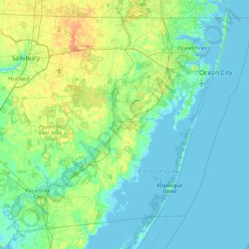
Name: Worcester County topographic map, elevation, terrain.

Location: Worcester County, Maryland, United States (37.99428 -75.66177 38.45204 -74.98520)

Average elevation: 20 ft

Minimum elevation: -10 ft

Maximum elevation: 92 ft

The terrain is mostly level and coastal. The lowest elevation is sea level along the Atlantic Ocean and the highest elevation is 49 ft (15 m) in the northwestern part of the county along State Route 12 just south of the Wicomico County line.

Wikipedia (CC-BY-SA 3.0)

Other topographic maps

Click on a map to view its topography, its elevation and its terrain.

Antietam

United States > Maryland > Washington County

Antietam, Washington County, Maryland, 21782, United States

Average elevation: 404 ft

College Park

United States > Maryland > Prince George's County

College Park, Prince George's County, Maryland, United States

Average elevation: 125 ft

Harford County

United States > Maryland

Harford County, Maryland, United States

Average elevation: 230 ft

Baltimore

United States > Maryland

Baltimore, Maryland, 21233, United States

Average elevation: 213 ft

Chesapeake Bay

United States > Maryland

Chesapeake Bay, Maryland, 23459, United States

Average elevation: 108 ft

Montgomery County

United States > Maryland

Montgomery County, Maryland, United States

Average elevation: 394 ft

Garrett County

United States > Maryland

Garrett County, Maryland, United States

Average elevation: 2,297 ft

Anne Arundel County

United States > Maryland

Anne Arundel County, Maryland, United States

Average elevation: 82 ft

Bethesda

United States > Maryland > Bethesda

Bethesda, Montgomery County, Maryland, 22814, United States

Average elevation: 282 ft

Carroll County

United States > Maryland

Carroll County, Maryland, United States

Average elevation: 623 ft

Washington County

United States > Maryland

Washington County, Maryland, United States

Average elevation: 640 ft

Annapolis

United States > Maryland > Anne Arundel County

Annapolis, Anne Arundel County, Maryland, United States

Average elevation: 26 ft

Flat Run

United States > Maryland > Frederick County > Emmitsburg

Flat Run, Emmitsburg, Frederick County, Maryland, United States

Average elevation: 453 ft

Kent Island

United States > Maryland > Queen Anne's County > Chester

Kent Island, Chester, Queen Anne's County, Maryland, United States

Average elevation: 3 ft

Bear Branch

United States > Maryland > Carroll County > Brown Heights

Bear Branch, Brown Heights, Carroll County, Maryland, United States

Average elevation: 476 ft

Silver Spring

United States > Maryland > Montgomery County > Silver Spring

Silver Spring, Montgomery County, Maryland, United States

Average elevation: 282 ft

Hagerstown

United States > Maryland > Washington County

Hagerstown, Washington County, Maryland, United States

Average elevation: 558 ft

Fountain Green

United States > Maryland > Harford County > Bel Air

Fountain Green, Bel Air, Harford County, Maryland, 21015, United States

Average elevation: 348 ft

Ocean City

United States > Maryland > Ocean City

Ocean City, Worcester County, Maryland, 21843, United States

Average elevation: 3 ft

Gaithersburg

United States > Maryland > Montgomery County

Gaithersburg, Montgomery County, Maryland, United States

Average elevation: 449 ft

Mount Airy

United States > Maryland > Carroll County

Mount Airy, Carroll County, Maryland, 21771, United States

Average elevation: 725 ft

Hereford

United States > Maryland > Baltimore County

Hereford, Baltimore County, Maryland, United States

Average elevation: 558 ft

Keedysville

United States > Maryland > Washington County

Keedysville, Washington County, Maryland, United States

Average elevation: 423 ft

Belle Grove Square

United States > Maryland > Carroll County > Westminster

Belle Grove Square, Westminster, Carroll County, Maryland, 21157, United States

Average elevation: 735 ft

Owings

United States > Maryland > Calvert County

Owings, Calvert County, Maryland, 20736, United States

Average elevation: 115 ft

Laytonsville

United States > Maryland > Montgomery County

Laytonsville, Montgomery County, Maryland, United States

Average elevation: 564 ft

Cecil County

United States > Maryland

Cecil County, Maryland, United States

Average elevation: 121 ft

Madonna

United States > Maryland > Harford County

Madonna, Harford County, Maryland, 21084, United States

Average elevation: 653 ft

Catonsville

United States > Maryland > Baltimore County

Catonsville, Baltimore County, Maryland, 21228, United States

Average elevation: 341 ft

Yorktown

United States > Maryland > Anne Arundel County > Glen Burnie

Yorktown, Glen Burnie, Anne Arundel County, Maryland, 21108, United States

Average elevation: 98 ft

Auth Village

United States > Maryland > Prince George's County > Camp Springs

Auth Village, Camp Springs, Prince George's County, Maryland, 20746, United States

Average elevation: 253 ft

Port Heights

United States > Maryland > Cecil County

Port Heights, Cecil County, Maryland, 21094, United States

Average elevation: 226 ft

Frostburg

United States > Maryland > Allegany County

Frostburg, Allegany County, Maryland, 21532, United States

Average elevation: 2,034 ft

Pasadena

United States > Maryland > Anne Arundel County

Pasadena, Anne Arundel County, Maryland, 21122, United States

Average elevation: 52 ft

Deer Park

United States > Maryland > Garrett County

Deer Park, Garrett County, Maryland, United States

Average elevation: 2,539 ft

Swanton

United States > Maryland > Garrett County

Swanton, Garrett County, Maryland, 21561, United States

Average elevation: 2,589 ft

Shallmar

United States > Maryland > Garrett County

Shallmar, Garrett County, Maryland, 21538, United States

Average elevation: 2,142 ft

Loch Lynn Heights

United States > Maryland > Garrett County

Loch Lynn Heights, Garrett County, Maryland, United States

Average elevation: 2,451 ft

Saint Inigoes Shores

United States > Maryland > Saint Mary's County

Saint Inigoes Shores, Saint Mary's County, Maryland, 20684, United States

Average elevation: 16 ft

Ocean Pines

United States > Maryland > Worcester County

Ocean Pines, Worcester County, Maryland, 21811, United States

Average elevation: 10 ft

Damascus

United States > Maryland > Montgomery County

Damascus, Montgomery County, Maryland, 20872, United States

Average elevation: 669 ft

Clarksburg

United States > Maryland > Montgomery County

Clarksburg, Montgomery County, Maryland, United States

Average elevation: 545 ft

White Oak

United States > Maryland > Montgomery County

White Oak, Montgomery County, Maryland, 20904, United States

Average elevation: 315 ft

Perry Hall

United States > Maryland > Baltimore County

Perry Hall, Baltimore County, Maryland, 21236, United States

Average elevation: 236 ft

Montgomery Village

United States > Maryland > Montgomery County

Montgomery Village, Montgomery County, Maryland, 20886, United States

Average elevation: 456 ft

Glenelg

United States > Maryland > Howard County

Glenelg, Howard County, Maryland, 21737, United States

Average elevation: 561 ft

Mount Rainier

United States > Maryland > Prince George's County

Mount Rainier, Prince George's County, Maryland, 20712, United States

Average elevation: 66 ft

Dundalk

United States > Maryland > Baltimore County

Dundalk, Baltimore County, Maryland, 21222, United States

Average elevation: 108 ft

Catoctin Creek

United States > Maryland > Frederick County > Middletown

Catoctin Creek, Middletown, Frederick County, Maryland, United States

Average elevation: 617 ft

Doubs

United States > Maryland > Frederick County > Adamstown

Doubs, Adamstown, Frederick County, Maryland, 21790, United States

Average elevation: 318 ft