
Sassafras Mountain topographic map
Interactive map
Click on the map to display elevation.
Sassafras Mountain
The Pisgah Quadrangle topographical map, revised 1904–1905, shows the long abandoned Sassafras Gap Road to be the preferred route through to Rosman, N.C. and Brevard, N.C. at the end of the 19th Century and that the existing Highway 178 was then a secondary road. This abandoned road is a short distance from the summit and is crossed by the hiking trail to Caesars Head from Sassafras summit. Most people crossing this old roadbed in Sassafras Gap don't recognize it as a road, but it is easily recognized because of the short section of steps going down into the roadbed, and a similar section of short steps on the opposite side of the roadbed going up and the trail then continuing steeply up toward Caesars Head. A short hike South down the old Sassafras Gap Road will take you to Hickory Head Spring, the headwater of the South Saluda River. Hickory Head Spring is shown as a feature on the Mill's Atlas, 1825, Greenville District, South Carolina.
About this map
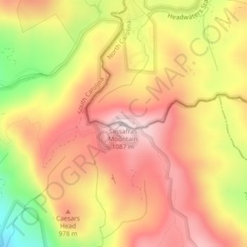
Name: Sassafras Mountain topographic map, elevation, terrain.
Average elevation: 2,936 ft
Minimum elevation: 2,047 ft
Maximum elevation: 3,514 ft
South Carolina trails, hiking, mountain biking, running and outdoor activities
Other topographic maps
Click on a map to view its topography, its elevation and its terrain.
Wando River
United States > South Carolina > Charleston County > Mount Pleasant
Average elevation: 10 ft
Pocosin
United States > South Carolina > Beaufort County > Hilton Head Island
Average elevation: 13 ft
Jenkins Island
United States > South Carolina > Beaufort County > Hilton Head Island
Average elevation: 3 ft
Wade Hampton
United States > South Carolina > Greenville County > Wildaire
Average elevation: 1,001 ft
Fort Moultrie
United States > South Carolina > Charleston County > Sullivan's Island
Average elevation: 0 ft
Fort Sumter
United States > South Carolina > Charleston County > Sullivan's Island
Average elevation: 0 ft
Huntington Beach State Park
United States > South Carolina > Georgetown County > Murrells Inlet
Average elevation: 7 ft
Andrew Jackson State Park
United States > South Carolina > Lancaster County > Lancaster
Average elevation: 541 ft
Georgia Street Park
United States > South Carolina > Greenville County > Fountain Inn
Average elevation: 843 ft
Jocassee Gorges Wildlife Management Area
United States > South Carolina > Pickens County
Average elevation: 1,726 ft
Peachtree Rock Heritage Preserve
United States > South Carolina > Lexington County
Average elevation: 486 ft
Barnwell State Park
United States > South Carolina > Barnwell County > Blackville
Average elevation: 276 ft
Paris Mountain State Park
United States > South Carolina > Greenville County
Paris Mountain lies in the Piedmont region of the United States. The mountain is a monadnock, a mountain that stands alone in an area. The word "monadnock" comes from Mount Monadnock in New Hampshire. The elevation of Paris Mountain exceeds 2,000 feet (609.6 m). The Piedmont region where Paris Mountain is…
Average elevation: 1,237 ft
Cherokee Falls
United States > South Carolina > Cherokee County > Cherokee Falls
Average elevation: 610 ft
Oak Grove
United States > South Carolina > Lexington County > Lakeview Terrace
Average elevation: 318 ft
Homeland Park
United States > South Carolina > Anderson County > Varennes Heights
Average elevation: 768 ft
Centerville
United States > South Carolina > Anderson County > Gilmer Estates
Average elevation: 791 ft
Lesslie
United States > South Carolina > York County
Lesslie has a total area of 6.0 square miles (16 km2), and an elevation of 701 feet (214 m).
Average elevation: 633 ft
Lyman Lake
United States > South Carolina > Spartanburg County > Cove Subdivision
Average elevation: 912 ft
Wedgewood
United States > South Carolina > Sumter County > Wedgefield > Wedgewood
Average elevation: 200 ft