Geolocate

Allamakee County topographic map

Interactive map

Click on the map to display elevation.

About this map

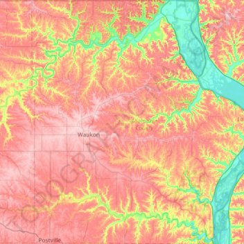
Name: Allamakee County topographic map, elevation, terrain.

Location: Allamakee County, Iowa, United States (43.07978 -91.61091 43.50099 -91.05791)

Average elevation: 1,007 ft

Minimum elevation: 600 ft

Maximum elevation: 1,342 ft

Iowa trails, hiking, mountain biking, running and outdoor activities

Other topographic maps

Click on a map to view its topography, its elevation and its terrain.

Clarksville

United States > Iowa > Butler County

Average elevation: 938 ft

Eldorado

United States > Iowa > Fayette County

Average elevation: 1,030 ft

Cosgrove

United States > Iowa > Johnson County

Average elevation: 748 ft

Mississippi River

United States > Iowa > Louisa County > New Boston

The uppermost lock and dam on the Upper Mississippi River is the Upper St. Anthony Falls Lock and Dam in Minneapolis. Above the dam, the river's elevation is 799 feet (244 m). Below the dam, the river's elevation is 750 feet (230 m). This 49-foot (15 m) drop is the largest of all the Mississippi River locks…

Average elevation: 554 ft

Ozark

United States > Iowa > Jackson County

Average elevation: 873 ft

Montpelier

United States > Iowa > Muscatine County

Average elevation: 614 ft

Fulton

United States > Iowa > Jackson County

Average elevation: 758 ft

Cordova

United States > Iowa > Marion County

Average elevation: 771 ft

Temple Hill

United States > Iowa > Jones County

Average elevation: 860 ft

Mississippi River

United States > Iowa > Scott County > Pleasant Valley Township

The uppermost lock and dam on the Upper Mississippi River is the Upper St. Anthony Falls Lock and Dam in Minneapolis. Above the dam, the river's elevation is 799 feet (244 m). Below the dam, the river's elevation is 750 feet (230 m). This 49-foot (15 m) drop is the largest of all the Mississippi River locks…

Average elevation: 587 ft

Daubendiek Park

United States > Iowa > Greene County > Jefferson

Average elevation: 1,040 ft

Stone State Park

United States > Iowa > Woodbury County > Sioux City

Average elevation: 1,230 ft

Adams Island

United States > Iowa > Clinton County

Average elevation: 587 ft

Beech

United States > Iowa > Warren County

Average elevation: 873 ft

Strand

United States > Iowa > Adams County

Average elevation: 1,230 ft

Hiteman

United States > Iowa > Monroe County

Average elevation: 837 ft

Mississippi River

United States > Iowa > Dubuque County > Dubuque > Eagle Point

The uppermost lock and dam on the Upper Mississippi River is the Upper St. Anthony Falls Lock and Dam in Minneapolis. Above the dam, the river's elevation is 799 feet (244 m). Below the dam, the river's elevation is 750 feet (230 m). This 49-foot (15 m) drop is the largest of all the Mississippi River locks…

Average elevation: 656 ft

Prussia

United States > Iowa > Adair County

Average elevation: 1,319 ft

Bonair

United States > Iowa > Howard County

Average elevation: 1,280 ft

Shopton Park

United States > Iowa > Lee County > Fort Madison

Average elevation: 545 ft

Paris

United States > Iowa > Linn County

Average elevation: 883 ft

Ozark

United States > Iowa > Jackson County

Average elevation: 873 ft

Rands

United States > Iowa > Calhoun County

Average elevation: 1,175 ft

Leeds

United States > Iowa > Woodbury County > Sioux City

Average elevation: 1,188 ft

Ramsey Island

United States > Iowa > Louisa County

Average elevation: 666 ft

Conover

United States > Iowa > Winneshiek County

Average elevation: 1,217 ft

Fort Dodge

United States > Iowa > Webster County > Fort Dodge > Fort Dodge

Average elevation: 1,129 ft

Iowa City

United States > Iowa > Johnson County > Iowa City

The elevation at the Iowa City Municipal Airport is 668 ft (203.6 m) above sea level.

Average elevation: 738 ft

Lenox

United States > Iowa > Taylor County > Lenox

Average elevation: 1,276 ft

Polk City

United States > Iowa > Polk County > Polk City > Polk City

Average elevation: 915 ft

Defiance

United States > Iowa > Shelby County > Defiance > Defiance

Average elevation: 1,316 ft

Moravia

United States > Iowa > Appanoose County > Moravia > Moravia

Average elevation: 978 ft

Clear Lake

United States > Iowa > Cerro Gordo County > Clear Lake > Clear Lake

Average elevation: 1,224 ft

Shenandoah

United States > Iowa > Page County > Shenandoah

Average elevation: 1,020 ft

Clarence

United States > Iowa > Cedar County > Clarence

Average elevation: 827 ft

Palisades Park

United States > Iowa > Winneshiek County > Decorah

Average elevation: 955 ft

Davenport

United States > Iowa > Scott County > Davenport

Average elevation: 696 ft

Westphalia

United States > Iowa > Shelby County > Westphalia > Westphalia

Average elevation: 1,398 ft

Middle Raccoon River

United States > Iowa > Carroll County > Carroll

Average elevation: 1,263 ft

Chatsworth

United States > Iowa > Sioux County > Chatsworth > Chatsworth

Average elevation: 1,178 ft

Wayland

United States > Iowa > Henry County > Wayland

Average elevation: 719 ft

Des Moines

United States > Iowa > Polk County > Des Moines

Average elevation: 889 ft

Spring Hill

United States > Iowa > Warren County > Spring Hill

Average elevation: 869 ft

Cumming

United States > Iowa > Warren County > Cumming > Cumming

Average elevation: 951 ft

Ames

United States > Iowa > Story County > Ames

Average elevation: 1,010 ft