
Washington topographic map
Click on the map to display elevation.
Washington
Washington State's topography is characterized by dramatic contrasts, shaped primarily by the formidable Cascade Mountain Range that divides the state into distinct western and eastern regions. The western part is marked by rugged mountains, lush forests, and a plethora of lakes, resulting from glacial activity. Here, Mount Rainier, standing at 14,410 feet, is the state's highest peak, surrounded by temperate rainforests that receive abundant rainfall, especially on the windward slopes. In contrast, Eastern Washington features a much drier landscape, with semi-arid conditions and rolling hills forming part of the Columbia Plateau, where annual precipitation can drop to as low as 6 inches. This stark difference in climate and geography, influenced by the rain shadow effect of the Cascades, gives rise to diverse ecosystems and agricultural regions, including fertile plains ideal for farming.
About this map
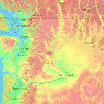
Name: Washington topographic map, elevation, terrain.
Location: Washington, United States (45.54373 -124.83609 49.00244 -116.91599)
Average elevation: 2,612 ft
Minimum elevation: -7 ft
Maximum elevation: 13,681 ft
United States trails, hiking, mountain biking, running and outdoor activities
Other topographic maps
Click on a map to view its topography, its elevation and its terrain.
San Francisco Bay Area
United States > California > San Francisco
The San Francisco Bay Area is characterized by a diverse and dynamic topography shaped by geological processes over millions of years. This region features a combination of coastal plains, steep hills, and rugged mountains, all influenced by the tectonic activity associated with the nearby San Andreas Fault…
Average elevation: 371 ft
Appalachian Mountains
United States > North Carolina > Yancey County
The Appalachian Mountains (French: Appalaches), often called the Appalachians, are a system of mountains in eastern to northeastern North America. The Appalachians first formed roughly 480 million years ago during the Ordovician Period. They once reached elevations similar to those of the Alps and the Rocky…
Average elevation: 4,800 ft
Baltimore
United States > Maryland > Baltimore
Baltimore is in north-central Maryland on the Patapsco River close to where it empties into the Chesapeake Bay. The city is also located on the fall line between the Piedmont Plateau and the Atlantic coastal plain, which divides Baltimore into "lower city" and "upper city". The city's elevation ranges from sea…
Average elevation: 213 ft
El Dorado Hills
United States > California > El Dorado County > Cameron Park
El Dorado Hills (EDH), as defined by the 2010 census-designated place (CDP), is at the western border of El Dorado County, between the City of Folsom and the unincorporated community of Cameron Park. The northern limits of the CDP are Folsom Lake and the South Fork of the American River, where river rafters…
Average elevation: 833 ft
Wolf Creek Lake
United States > North Carolina > Jackson County > Wolf Mountain
Average elevation: 3,350 ft
Rocky Mountains
United States > Wyoming > Teton County
Agriculture and forestry are major industries. Agriculture includes dryland and irrigated farming and livestock grazing. Livestock are frequently moved between high-elevation summer pastures and low-elevation winter pastures, a practice known as transhumance.
Average elevation: 7,520 ft
Palm Harbor
United States > Florida > Pinellas County
Palm Harbor is characterized by its unique topography, which features a relatively rare hilly landscape for the region. Unlike much of the surrounding areas in Pinellas County, which are predominantly flat, Palm Harbor includes elevations that can reach up to about 75 feet above sea level. This elevation gives…
Average elevation: 30 ft
Pocono Summit
United States > Pennsylvania > Monroe County > Tobyhanna Township
Average elevation: 1,804 ft
Candlewood Lake Club
United States > Connecticut > Western Connecticut Planning Region > New Milford
Average elevation: 469 ft
San Fernando Valley
United States > California > Los Angeles County > Los Angeles
Average elevation: 1,627 ft
Appalachian Mountains
United States > North Carolina > Yancey County
The Appalachian Mountains (French: Appalaches), often called the Appalachians, are a system of mountains in eastern to northeastern North America. The Appalachians first formed roughly 480 million years ago during the Ordovician Period. They once reached elevations similar to those of the Alps and the Rocky…
Average elevation: 4,800 ft
Albuquerque
United States > New Mexico > Bernalillo County
Albuquerque is located in north-central New Mexico. To its east are the Sandia–Manzano Mountains. The Rio Grande flows north to south through its center, while the West Mesa and Petroglyph National Monument make up the western part of the city. Albuquerque has one of the highest elevations of any major city…
Average elevation: 5,482 ft
Evergreen
United States > Colorado > Jefferson County
Evergreen sits at an elevation of 7,220 feet (2,200 m) in the Rocky Mountains, 19 miles west of Denver, Colorado. Its addresses are oriented according to the Street_system_of_Denver.
Average elevation: 7,575 ft
Florida Keys
United States > Florida > Monroe County
Tropical cyclones present special dangers and challenges to the entire Keys. Because no area of the islands is more than 20 feet (6.1 m) above sea level (and many are only a few feet elevation), and water surrounds the islands, nearly every neighborhood is subject to flooding as well as hurricane winds. In…
Average elevation: 0 ft
West Glacier
United States > Montana > Flathead County
The community, heavily dependent on tourism, has a small permanent population that expands significantly during the summer tourist season; most area businesses are likewise seasonal—including the 18-hole golf course—and are primarily geared towards travelers. The elevation is 3,169 feet (966 m).
Average elevation: 3,940 ft
Estes Park
United States > Colorado > Larimer County
Estes Park sits at an elevation of 7,522 feet (2,293 m) on the front range of the Rocky Mountains at the eastern entrance of the Rocky Mountain National Park. Its north, south and east extremities border the Roosevelt National Forest. Lumpy Ridge lies immediately north of Estes Park.
Average elevation: 8,343 ft
Indianapolis
United States > Indiana > Indianapolis
Indianapolis is within the Tipton Till Plain, a flat to gently sloping terrain underlain by glacial deposits known as till. The lowest point in the city is about 650 feet (198 m) above mean sea level, with the highest natural elevation at about 900 feet (274 m) above sea level. Few hills or short ridges, known…
Average elevation: 791 ft
Grand Lake
United States > Colorado > Grand County
Established in 1881, Grand Lake sits at an elevation of 8,369 feet (2,551 m) and derives its name from the lake on whose shores it is situated: Grand Lake, the largest natural body of water in Colorado. The town of Grand Lake was originally an outfitting and supply point for the mining settlements of Lulu…
Average elevation: 8,629 ft
Lutz
United States > Florida > Hillsborough County > Tampa
Lutz is characterized by a gently rolling topography that showcases the distinctive features of the central Florida landscape. The area has an average elevation of about 70 feet (21 meters) above sea level, contributing to its mild undulations rather than dramatic elevation changes. The terrain is marked by a…
Average elevation: 66 ft
Navarre
United States > Florida > Santa Rosa County
Navarre is located at 30°24′04″N 86°51′47″W / 30.401°N 86.863°W / 30.401; -86.863Coordinates: 30°24′04″N 86°51′47″W / 30.401°N 86.863°W / 30.401; -86.863. It is located within a portion of the Florida Panhandle observing the Central Time Zone. Elevation is at an average of 10 feet (3.0 m).
Average elevation: 13 ft
Virginia Beach
United States > Virginia > Virginia Beach
According to the United States Census Bureau, the city has a total area of 497 square miles (1,290 km2), of which 249 square miles (640 km2) is land and 248 square miles (640 km2) (49.9%) is water. It is the largest city in Virginia by total area and third-largest city land area. The average elevation is 12…
Average elevation: 7 ft
Jensen Beach
United States > Florida > Martin County
The Skyline Drive area includes some of the highest points in the community, reaching an elevation of 70 feet (21 m) at one point.
Average elevation: 16 ft
Denali
United States > Alaska > Denali Borough
Denali (/dəˈnɑːli/ də-NAH-lee), federally designated as Mount McKinley, is the highest mountain peak in North America, with a summit elevation of 20,310 feet (6,190 m) above sea level. It is the tallest mountain in the world from base to peak on land, measuring 18,000 ft (5,500 m). With a topographic…
Average elevation: 18,196 ft
Lakeville
United States > Connecticut > Northwest Hills Planning Region > Salisbury
Average elevation: 850 ft
Mount McLoughlin
United States > Oregon > Jackson County
The major landmark for the Rogue River Valley, Mount McLoughlin reaches an elevation of 9,493 ft (2,893 m). The tallest volcano in between Mount Shasta — located 70 mi (110 km) to the south — and South Sister 120 miles (190 km) to the north, it lies in the Cascade Range, in the southern portion of the U.S.…
Average elevation: 7,533 ft
Highland Range Crucial Bighorn Habitat Area
United States > Nevada > Clark County
Average elevation: 3,009 ft
Port Charlotte
United States > Florida > Charlotte County
Port Charlotte is characterized by a predominantly flat and low-lying terrain, typical of Florida’s coastal landscape. The area features a network of waterways, including the Peace River and Charlotte Harbor, which provide ample opportunities for recreational activities like boating and fishing. Elevations…
Average elevation: 13 ft
Cajon Pass
United States > California > San Bernardino County
Cajon Pass (/kəˈhoʊn/; Spanish: Puerto del Cajón or Paso del Cajón) is a mountain pass between the San Bernardino Mountains to the east and the San Gabriel Mountains to the west in Southern California. Created by the movements of the San Andreas Fault, it has an elevation of 3,777 ft (1,151 m). Located in…
Average elevation: 3,835 ft
Mount Mitchell
United States > North Carolina > Yancey County
Mount Mitchell, known in Cherokee as Attakulla, is the highest peak of the Appalachian Mountains and the highest peak in mainland eastern North America. It is located near Burnsville in Yancey County, North Carolina in the Black Mountain subrange of the Appalachians about 19 miles (31 km) northeast of…
Average elevation: 5,719 ft
Big Sur
United States > California > Monterey County
The highest peaks of the crest of the coast range are located at an average distance from the coast of three and a half miles [5.6 km]. In this distance they rise to elevations of from three thousand six hundred to five thousand feet [1,100 to 1,500 m] above the sea-level. From San Carpoforo Creek to…
Average elevation: 633 ft
Rocky Mountains
United States > Wyoming > Teton County
Agriculture and forestry are major industries. Agriculture includes dryland and irrigated farming and livestock grazing. Livestock are frequently moved between high-elevation summer pastures and low-elevation winter pastures, a practice known as transhumance.
Average elevation: 7,520 ft
Blue Ridge Mountains
United States > Virginia > Botetourt County
Although the term "Blue Ridge" is sometimes applied exclusively to the eastern edge or front range of the Appalachian Mountains, the geological definition of the Blue Ridge province extends westward to the Ridge and Valley area, encompassing the Great Smoky Mountains, the Great Balsams, the Roans, the Blacks,…
Average elevation: 1,509 ft
Estes Park
United States > Colorado > Larimer County
Estes Park sits at an elevation of 7,522 feet (2,293 m) on the front range of the Rocky Mountains at the eastern entrance of the Rocky Mountain National Park. Its north, south and east extremities border the Roosevelt National Forest. Lumpy Ridge lies immediately north of Estes Park.
Average elevation: 7,940 ft
Little Saint James Island
United States > United States Virgin Islands > Saint Thomas - Saint John District
Average elevation: 3 ft
Columbus
United States > Ohio > Franklin County > Columbus
The confluence of the Scioto and Olentangy rivers is just north-west of Downtown Columbus. Several smaller tributaries course through the Columbus metropolitan area, including Alum Creek, Big Walnut Creek, and Darby Creek. Columbus is considered to have relatively flat topography thanks to a large glacier that…
Average elevation: 837 ft
Orlando
United States > Florida > Orange County
According to the Köppen climate classification, Orlando has a humid subtropical climate (Cfa) like much of the deep Southern United States. The two basic seasons in Orlando are a hot and rainy season, lasting from May until late October (roughly coinciding with the Atlantic hurricane season), and a warm and…
Average elevation: 95 ft
Mauna Kea
United States > Hawaii > Hawaiʻi County
Mauna Kea (/ˌmaʊnə ˈkeɪə/; Hawaiian: [ˈmɐwnə ˈkɛjə]; abbreviation for Mauna a Wākea) is a dormant volcano on the island of Hawaiʻi. Its peak is 4,207.3 m (13,803 ft) above sea level, making it the highest point in the state of Hawaiʻi and second-highest peak of an island on Earth. The peak is…
Average elevation: 13,051 ft
Central Park
United States > New York > New York County > New York
In June 1856, Fernando Wood appointed a "consulting board" of seven people, headed by author Washington Irving, to inspire public confidence in the proposed development. Wood hired military engineer Egbert Ludovicus Viele as the park's chief engineer, tasking him with a topographical survey of the site. The…
Average elevation: 85 ft
Uinta Mountains
The high Uintas were extensively glaciated during the last ice age, and most of the large stream valleys on both the north and south sides of the range held long valley glaciers. However, despite reaching to over 13,500 feet (4,110 m) in elevation, the climate today is sufficiently dry that no glaciers…
Average elevation: 7,753 ft
Central Park
United States > New York > New York County > New York
In June 1856, Fernando Wood appointed a "consulting board" of seven people, headed by author Washington Irving, to inspire public confidence in the proposed development. Wood hired military engineer Egbert Ludovicus Viele as the park's chief engineer, tasking him with a topographical survey of the site. The…
Average elevation: 85 ft
Rocky Mountains
United States > Wyoming > Teton County
Agriculture and forestry are major industries. Agriculture includes dryland and irrigated farming and livestock grazing. Livestock are frequently moved between high-elevation summer pastures and low-elevation winter pastures, a practice known as transhumance.
Average elevation: 7,520 ft