
Switzerland County topographic map
Click on the map to display elevation.
Switzerland County
Switzerland County lies at the SE tip of Indiana, with its southeastern border defined by the Ohio River; the state of Kentucky abuts on the opposite shore. Its rolling hills were originally completely wooded. Its more flat areas have been cleared for agricultural or urban use, but its many drainages are still wooded. Its highest elevation (981 feet/299 meters ASL) is a hill in its NW quadrant, 0.7 miles (1.1 km) west of Avonburg.
About this map
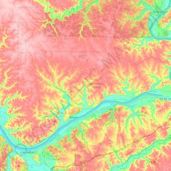
Name: Switzerland County topographic map, elevation, terrain.
Location: Switzerland County, Indiana, United States (38.68751 -85.20351 38.92942 -84.78461)
Average elevation: 738 ft
Minimum elevation: 430 ft
Maximum elevation: 988 ft
Other topographic maps
Click on a map to view its topography, its elevation and its terrain.
Indianapolis
United States > Indiana > Indianapolis
Indianapolis is within the Tipton Till Plain, a flat to gently sloping terrain underlain by glacial deposits known as till. The lowest point in the city is about 650 feet (198 m) above mean sea level, with the highest natural elevation at about 900 feet (274 m) above sea level. Few hills or short ridges, known…
Average elevation: 791 ft
Indiana Dunes State Park
United States > Indiana > Porter County > Chesterton
Average elevation: 610 ft
Johnson Lake
United States > Indiana > Jefferson County > Madison > North Madison
Average elevation: 873 ft
Hoosier Hill
United States > Indiana > Wayne County
Hoosier Hill is the highest natural point in the U.S. state of Indiana with a claimed elevation of 1,257 feet (383 meters) above sea level. Hoosier Hill's claimed elevation is based on SRTM digital elevation data which is now considered to be outdated. Using newer elevation tools such as USGS's 3DEP, the top…
Average elevation: 1,224 ft
Freedom Park
United States > Indiana > Johnson County > Greenwood > Green Valley
Average elevation: 797 ft