
闵行区 topographic map
Interactive map
Click on the map to display elevation.
About this map
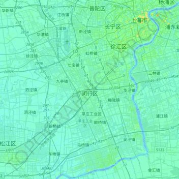
Name: 闵行区 topographic map, elevation, terrain.
Location: 闵行区, 上海市, 中国 (30.97834 121.23636 31.26156 121.57182)
Average elevation: 16 ft
Minimum elevation: -13 ft
Maximum elevation: 131 ft
闵行区全境为冲积平原,仅西部冈身部分略高。海拔平均高度在4米左右,地势平坦,略呈东高西低。
Other topographic maps
Click on a map to view its topography, its elevation and its terrain.