
Make a donation
Gear up for your next adventure:
As an Amazon Associate, this site earns from qualifying purchases at no extra cost to you.
Demer topographic map
Click on the map to display elevation.
Make a donation
Gear up for your next adventure:
As an Amazon Associate, this site earns from qualifying purchases at no extra cost to you.
Demer
Ter hoogte van Aarschot takte de Laak zich vroeger af van de Demer om parallel met deze naar het westen te stromen.Nu wil de Vlaamse Waterweg, SIGMA plan, die opnieuw koppelen vanaf Betekom.
Make a donation
Gear up for your next adventure:
As an Amazon Associate, this site earns from qualifying purchases at no extra cost to you.
About this map
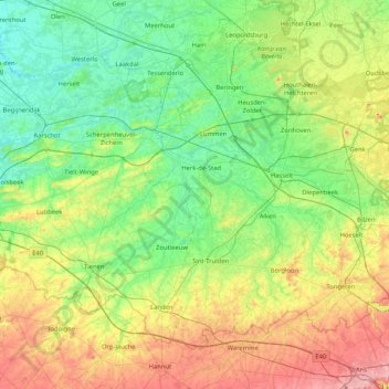
Name: Demer topographic map, elevation, terrain.
Location: Demer, Limburg, Vlaanderen, België (50.79922 4.69261 51.00898 5.52224)
Average elevation: 210 ft
Minimum elevation: 10 ft
Maximum elevation: 702 ft
Make a donation
Gear up for your next adventure:
As an Amazon Associate, this site earns from qualifying purchases at no extra cost to you.
Other topographic maps
Click on a map to view its topography, its elevation and its terrain.
Make a donation
Gear up for your next adventure:
As an Amazon Associate, this site earns from qualifying purchases at no extra cost to you.
Kesselt
België > Limburg > Tongeren > Lanaken > Veldwezelt
Kesselt behoort tot de streek Droog-Haspengouw. Het ligt geologisch gezien op een plateau, dat omwille van de unieke kleisoort genoemd is naar het dorp (plateau van Kesselt). Het dorp geniet dan ook enige regionale bekendheid omwille van haar steenbakkerij. Kesselt ligt op een hoogte van ongeveer 98 meter. Ten…
Average elevation: 276 ft
Make a donation
Gear up for your next adventure:
As an Amazon Associate, this site earns from qualifying purchases at no extra cost to you.
Offelken
België > Limburg > Tongeren > Tongeren
Offelken ligt in Droog-Haspengouw. De hoogte varieert tussen 88 en 98 meter. De kern van het gehucht ligt ten zuiden van de aftakking van de Oude Jeker. Deze waterloop werd aangelegd door de mens en heeft een lengte van ongeveer drie kilometer.
Average elevation: 315 ft
Make a donation
Gear up for your next adventure:
As an Amazon Associate, this site earns from qualifying purchases at no extra cost to you.
Waterloos
België > Limburg > Maaseik > Maaseik > Neeroeteren
Het gehucht ligt op het overgangsgebied van de Vlakte van Bocholt en het Kempens Plateau op een hoogte van ongeveer 50 meter. Direct ten westen van Waterloos is er een steilrand naar het plateau dat gelegen is op een hoogte van zo'n 70 meter.
Average elevation: 157 ft
Make a donation
Gear up for your next adventure:
As an Amazon Associate, this site earns from qualifying purchases at no extra cost to you.
Make a donation
Gear up for your next adventure:
As an Amazon Associate, this site earns from qualifying purchases at no extra cost to you.
Make a donation
Gear up for your next adventure:
As an Amazon Associate, this site earns from qualifying purchases at no extra cost to you.
Winterslag
België > Limburg > Hasselt > Genk
Winterslag, gelegen op het Kempens Plateau, werd vrijwel geheel door de steenkoolmijn gevormd. Ook nu is er nog een terril met een hoogte van 163 meter boven de zeespiegel. De mijnterreinen en woonwijken zijn ingebed te midden van autowegen en spoorlijnen, en ook zijn in de omgeving nog enkele bosrestanten te…
Average elevation: 240 ft
Make a donation
Gear up for your next adventure:
As an Amazon Associate, this site earns from qualifying purchases at no extra cost to you.
Make a donation
Gear up for your next adventure:
As an Amazon Associate, this site earns from qualifying purchases at no extra cost to you.
Make a donation
Gear up for your next adventure:
As an Amazon Associate, this site earns from qualifying purchases at no extra cost to you.
Alt-Hoeselt
België > Limburg > Tongeren > Hoeselt
Het plateau, met een hoogte tot 100 meter, wordt benut voor landbouw en fruitteelt.
Average elevation: 279 ft
Make a donation
Gear up for your next adventure:
As an Amazon Associate, this site earns from qualifying purchases at no extra cost to you.
Make a donation
Gear up for your next adventure:
As an Amazon Associate, this site earns from qualifying purchases at no extra cost to you.
Make a donation
Gear up for your next adventure:
As an Amazon Associate, this site earns from qualifying purchases at no extra cost to you.
Make a donation
Gear up for your next adventure:
As an Amazon Associate, this site earns from qualifying purchases at no extra cost to you.
Make a donation
Gear up for your next adventure:
As an Amazon Associate, this site earns from qualifying purchases at no extra cost to you.
Make a donation
Gear up for your next adventure:
As an Amazon Associate, this site earns from qualifying purchases at no extra cost to you.
Blauwe Kei
België > Limburg > Maaseik > Lommel
Blauwe Kei is een plaats in de Belgische stad Lommel in de provincie Limburg. Blauwe Kei is ontstaan na het graven van het kanaal Bocholt-Herentals, ter hoogte van de eerste sluis, en valt onder het gehucht Lommel-Werkplaatsen (Lommel-Fabriek). Iets verder richting Antwerpen is tevens de aftakking van Kanaal…
Average elevation: 128 ft
Make a donation
Gear up for your next adventure:
As an Amazon Associate, this site earns from qualifying purchases at no extra cost to you.
Make a donation
Gear up for your next adventure:
As an Amazon Associate, this site earns from qualifying purchases at no extra cost to you.
Erkend natuurreservaat Munsterbos
België > Limburg > Tongeren > Bilzen > Munsterbilzen
Average elevation: 171 ft
Make a donation
Gear up for your next adventure:
As an Amazon Associate, this site earns from qualifying purchases at no extra cost to you.
Make a donation
Gear up for your next adventure:
As an Amazon Associate, this site earns from qualifying purchases at no extra cost to you.
Make a donation
Gear up for your next adventure:
As an Amazon Associate, this site earns from qualifying purchases at no extra cost to you.
Make a donation
Gear up for your next adventure:
As an Amazon Associate, this site earns from qualifying purchases at no extra cost to you.
Make a donation
Gear up for your next adventure:
As an Amazon Associate, this site earns from qualifying purchases at no extra cost to you.
Make a donation
Gear up for your next adventure:
As an Amazon Associate, this site earns from qualifying purchases at no extra cost to you.
Borgloon
Borgloon ligt op het Massief van Borgloon, dat tot 131 meter hoogte gaat en zich tot ongeveer 30 meter boven de Haspengouwse schiervlakte verheft. Door erosie zijn er ook insnijdingen gevormd. Het laagste punt van dit heuvelachtige landschap ligt op ongeveer 65 meter. Ten noorden daarvan ligt de steilrand van…
Average elevation: 246 ft
Make a donation
Gear up for your next adventure:
As an Amazon Associate, this site earns from qualifying purchases at no extra cost to you.
Kortessem
België > Limburg > Hasselt > Hasselt
Het dorp ontstond als een driehoekige nederzetting, geflankeerd door de Heerbaan van Hasselt naar Tongeren (tegenwoordig: Mersenhovenstraat), de Klokkenhofsteeg en de (huidige) Dorpsstraat. Van belang is de weg van Hasselt naar Tongeren, welke omstreeks 1740 werd aangelegd (zie: Steenweg op Luik). De…
Average elevation: 174 ft
Make a donation
Gear up for your next adventure:
As an Amazon Associate, this site earns from qualifying purchases at no extra cost to you.