Geolocate

Azad Kashmir topographic map

Click on the map to display elevation.

About this map

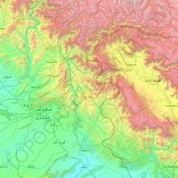
Name: Azad Kashmir topographic map, elevation, terrain.

Location: Azad Kashmir, Pakistan (32.77012 73.39032 35.13281 74.93568)

Average elevation: 5,607 ft

Minimum elevation: 715 ft

Maximum elevation: 20,033 ft

Other topographic maps

Click on a map to view its topography, its elevation and its terrain.

Chiniot

Pakistan > Punjab

Chiniot is at the intersection of the Faisalabad-Sargodha and Lahore-Jhang roads. It is 158 km (98 mi) northwest of Lahore and 38 km (24 mi) north of Faisalabad. Chiniot city is spread over an area of 10 km2 (3.9 sq mi) with an average elevation of 179 metres (587 ft).

Average elevation: 600 ft

Kallar Kahar

Pakistan > Punjab

Average elevation: 2,267 ft

Karachi

Pakistan > Sindh > Karachi South District > Saddar Town

Karachi lies very close to a major fault line, where the Indian tectonic plate meets the Arabian tectonic plate. Within the city of Karachi are two small ranges: the Khasa Hills and Mulri Hills, which lie in the northwest and act as a barrier between North Nazimabad and Orangi. Karachi's hills are barren and…

Average elevation: 66 ft

Guddu Barrage

Pakistan > Sindh > Kashmore District > Guddu

Average elevation: 253 ft

Bansra Gali

Pakistan > Punjab > Murree District

Average elevation: 5,607 ft

Panjgur

Pakistan > Balochistan > Panjgur District

Average elevation: 3,228 ft

Kurram River

Pakistan > Khyber Pakhtunkhwa

Generally, the topography of the catchment area of the Kurrama River is mountainous in the upper reaches near Ali Khayl, Mirazi Kalay, Peer Kalai, Kharlachi, Parachinar and Thal areas. Near Bannu city, the river flattens up and follows a consistent mild slope up to its outfall in to the Indus River near Isa…

Average elevation: 1,430 ft

Shewa

Pakistan > Khyber Pakhtunkhwa > Swabi District

Average elevation: 1,214 ft

Miani

Pakistan > Punjab

Average elevation: 807 ft

Raiwind

Pakistan > Punjab

Average elevation: 673 ft

Pindi Rawan

Pakistan > Punjab

Average elevation: 673 ft

Rawalpindi

Pakistan > Punjab > Rawalpindi District > Rawalpindi Cantonment

Rawalpindi features a humid subtropical climate (Köppen: Cwa) with hot and wet summers, a cooler and drier winter. Rawalpindi and its twin city Islamabad, during the year experiences an average of 91 thunderstorms, which is the highest frequency of any plain elevation city in the country. Strong windstorms…

Average elevation: 1,739 ft

Wadana

Pakistan > Punjab > Kasur District

Average elevation: 686 ft

Kanju

Pakistan > Khyber Pakhtunkhwa > Swat District

Average elevation: 3,120 ft

Mastuj

Pakistan > Khyber Pakhtunkhwa > Chitrāl District

Mastuj (Urdu: مستوج) is a town and Tehsil of Upper Chitral District in Khyber-Pakhtunkhwa province of Pakistan. It is located at 36°17'0N 72°31'0E with an altitude of 2359 metres (7742 feet). There are ruins of old fort built originally in 18th century and reconstructed several times.

Average elevation: 10,036 ft

Kalar Kahar Lake

Pakistan > Punjab > Kallar Kahar

Average elevation: 2,195 ft

Sajikot

Pakistan > Khyber Pakhtunkhwa > Abbottābād District

Average elevation: 4,977 ft

Mithi

Pakistan > Sindh > Tharparkar District

The town is located at 24°74'0N 69°80'0E with an altitude of 28 meters (92 feet). It lies 450 kilometers from Karachi and is located in a desert area. The geography of Mithi is characterized by its arid landscape, typical of the Thar Desert, which influences the climate, agriculture, and daily life in the…

Average elevation: 184 ft

Indus River (branch)

Pakistan > Sindh > Sukkur District > Sukkur

Average elevation: 200 ft

Saado

Pakistan > Punjab

Average elevation: 712 ft

Patriata

Pakistan > Punjab > Murree District

Average elevation: 6,178 ft

Goleki

Pakistan > Punjab > Gujrat District

Average elevation: 732 ft

Sibi

Pakistan > Balochistan > Sibi District

Average elevation: 558 ft

Charbagh

Pakistan > Khyber Pakhtunkhwa > Swat District

Average elevation: 3,760 ft

Kotli

Pakistan > Azad Kashmir > Kotli District

Average elevation: 2,428 ft

Sultan Colony

Pakistan > Punjab

Average elevation: 705 ft

Jhangar Hakim Wala

Pakistan > Punjab

Average elevation: 646 ft

Zarobi

Pakistan > Khyber Pakhtunkhwa > Swabi District

Zarobai Munara, commonly known as Zarobi, is a historical village and Union Council of Swabi District in the Khyber Pakhtunkhwa province of Pakistan. It is located at 34°2′0N 72°34′0E with an altitude of 321 metres (1056 feet).

Average elevation: 1,063 ft

Topi

Pakistan > Khyber Pakhtunkhwa > Swabi District

Average elevation: 1,188 ft

Keer

Pakistan > Punjab

Average elevation: 702 ft

Jaglot

Pakistan > Gilgit-Baltistan > Gilgit District

Average elevation: 7,372 ft

Minimarg

Pakistan > Gilgit-Baltistan > Astore District

Average elevation: 10,676 ft

Jhal Magsi

Pakistan > Balochistan > Jhal Magsi District

Average elevation: 220 ft

Gilgit

Pakistan > Gilgit-Baltistan > Gilgit District

Gilgit lacks significant rainfall, averaging in 120 to 240 mm (4.7 to 9.4 in) annually, as monsoon breaks against the southern range of Himalayas. Irrigation for land cultivation is obtained from the rivers, abundant with melting snow water from higher altitudes.

Average elevation: 9,849 ft

Jagatpur

Pakistan > Punjab

Average elevation: 778 ft

Dardyal

Pakistan > Khyber Pakhtunkhwa > Swat District

Average elevation: 5,535 ft

Attock

Pakistan > Punjab > Attock District

Average elevation: 1,286 ft

Angelus

Pakistan > Gilgit-Baltistan > Shigar District

Average elevation: 19,114 ft

Chichawatni

Pakistan > Punjab

Average elevation: 518 ft

Balhrejee

Pakistan > Sindh > Lārkāna District

Average elevation: 161 ft

Ahmed Pur

Pakistan > Sindh > Khairpur District

Average elevation: 184 ft

Mud Volcano

Pakistan > Balochistan > Gwadar District

Average elevation: 39 ft

Khyber

Pakistan > Gilgit-Baltistan

Average elevation: 10,505 ft

Surachand

Pakistan > Sindh > Tharparkar District

Average elevation: 121 ft

Usto Bhaledino

Pakistan > Sindh > Jacobabad District

Average elevation: 184 ft

Isa Khel

Pakistan > Punjab

Average elevation: 682 ft

Kundal Shahi

Pakistan > Azad Kashmir > Athmuqam Tehsil

Average elevation: 5,663 ft

Mingora

Pakistan > Khyber Pakhtunkhwa > Swat District

Average elevation: 4,544 ft

Sakhi Sarwar

Pakistan > Punjab

Average elevation: 1,050 ft

Khuzdar

Pakistan > Balochistan > Khuzdar District

Khuzdar is at the apex of a narrow valley at an elevation of 1,237 metres (4,058 ft). Despite this altitude, Khuzdar like most of Balochistan has an arid climate (Köppen BWh) with very low and erratic rainfall. Unlike most parts of the province, the heaviest average rainfall comes from the Asian monsoon in…

Average elevation: 4,649 ft

Lakarmar

Pakistan > Punjab > Attock District

Average elevation: 1,394 ft

Sunigram Kalay

Pakistan > Khyber Pakhtunkhwa > Buner District

Average elevation: 2,388 ft

Jhudo

Pakistan > Sindh > Mirpur Khas District

Average elevation: 30 ft

Gorikot

Pakistan > Gilgit-Baltistan > Astore District

Average elevation: 8,655 ft

Kachura

Pakistan > Gilgit-Baltistan > Skardu District

Average elevation: 7,923 ft

Thatta

Pakistan > Punjab

Average elevation: 725 ft

Minapin Nagar

Pakistan > Gilgit-Baltistan > Nagar District

Average elevation: 7,572 ft

Chak No 57 NL

Pakistan > Punjab

Average elevation: 545 ft

M-Block Park

Pakistan > Punjab

Average elevation: 617 ft

Bhera

Pakistan > Punjab > Sargodha District

Average elevation: 646 ft

Shogore

Pakistan > Malakand Division > Chitrāl District

Average elevation: 7,365 ft

Passu

Pakistan > Gilgit-Baltistan

Average elevation: 8,793 ft

Sargodha

Pakistan > Punjab

Average elevation: 617 ft

Malir

Pakistan > Sindh

Average elevation: 95 ft

Wana

Pakistan > Dera Ismail Khan Division

Average elevation: 4,698 ft

Haji Khan Dombki

Pakistan > Sindh

Average elevation: 240 ft

Rattu

Pakistan > Gilgit-Baltistan

Average elevation: 9,675 ft

North Karachi

Pakistan > Sindh > Karachi Division

Average elevation: 174 ft

Civil Lines

Pakistan > Punjab

Average elevation: 709 ft

Mari Indus

Pakistan > Punjab > Mari Indus

Average elevation: 732 ft

Dhamtal

Pakistan > Punjab

Average elevation: 853 ft

Swabi

Pakistan > Khyber Pakhtunkhwa

Average elevation: 1,020 ft

Khairpur

Pakistan > Sindh

Average elevation: 213 ft

Adil Pur عادل پور

Pakistan > Sindh

Average elevation: 223 ft

Frano

Pakistan > Gilgit-Baltistan > Ghanche District

Average elevation: 10,535 ft

Hangu

Pakistan > Khyber Pakhtunkhwa

Average elevation: 3,009 ft

Dhani Bux Junejo

Pakistan > Sindh

Average elevation: 164 ft

Isa

Pakistan > Balochistan

Average elevation: 16 ft

Langrial

Pakistan > Punjab

Average elevation: 971 ft

Mīrpur Sakro

Pakistan > Sindh > Mirpur Sakro Tehsil

Average elevation: 16 ft

Muzaffargarh

Pakistan > Punjab

Average elevation: 397 ft

Chakwal

Pakistan > Punjab

Average elevation: 1,726 ft

Khanewal

Pakistan > Punjab

Average elevation: 443 ft

Miranjani

Pakistan > Khyber Pakhtunkhwa

Miranjani is the highest peak in Galyat Region which is located at the elevation of 2,992 metres (9,816 ft), in Abbottabad District of Khyber Pakhtunkhwa the Province of Pakistan. It is located in the Namli Maira area, in Ayubia National Park, 80 kilometres (50 mi) north of Islamabad in the western Himalayan…

Average elevation: 8,350 ft

Korangi

Pakistan > Sindh

Average elevation: 30 ft

Munda

Pakistan > Punjab > Munda

Average elevation: 449 ft

Mohenjo-daro

Pakistan > Sindh

Average elevation: 164 ft

Gear up for your next adventure:

😴Insulated Sleeping Pads - Compact and warm pads for high-elevation camping
🥇GPS Hiking Watch - Multi‑sport GPS watch with navigation and trail tracking
📚Navigation Handbooks - Master the art of reading topographic maps and using a compass
🗺️Topographic Maps - Detailed topo maps for hiking, exploring and outdoor navigation
🪶Compact Camp Shovel - Folding shovel for campsite tasks

As an Amazon Associate, this site earns from qualifying purchases at no extra cost to you.