
Brunswick topographic map
Click on the map to display elevation.
About this map
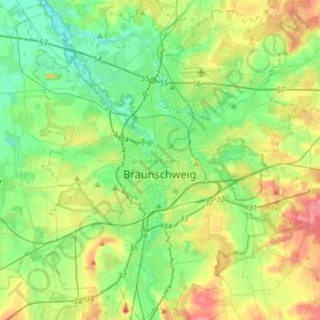
Name: Brunswick topographic map, elevation, terrain.
Location: Brunswick, Lower Saxony, Germany (52.18679 10.41245 52.35738 10.64324)
Average elevation: 272 ft
Minimum elevation: 194 ft
Maximum elevation: 420 ft
Other topographic maps
Click on a map to view its topography, its elevation and its terrain.
Kamschlacken
Germany > Lower Saxony > Landkreis Göttingen > Osterode am Harz > Riefensbeek-Kamschlacken
Average elevation: 1,683 ft
Hagelshoek
Germany > Lower Saxony > Landkreis Grafschaft Bentheim > Bad Bentheim > Gildehaus
Average elevation: 157 ft
Zoll
Germany > Lower Saxony > Landkreis Göttingen > Bad Lauterberg im Harz > Barbis
Average elevation: 1,033 ft
Klein Schweinebrück
Germany > Lower Saxony > Landkreis Friesland > Zetel > Schweinebrück
Average elevation: 30 ft
Pötzen
Germany > Lower Saxony > Landkreis Hameln-Pyrmont > Hessisch Oldendorf
Average elevation: 656 ft
Klein Eissel
Germany > Lower Saxony > Landkreis Verden > Verden (Aller) > Eissel bei Verden
Average elevation: 36 ft
Lüneburg Heath
Germany > Lower Saxony > Heidekreis > Soltau > Hötzingen > Emhof
Average elevation: 279 ft
Schatteburg
Germany > Lower Saxony > Landkreis Leer > Backemoor > Schatteburg
Average elevation: 10 ft
Schwagstorf
Germany > Lower Saxony > Landkreis Osnabrück > Fürstenau > Schwagstorf
Average elevation: 276 ft