
Make a donation
Gear up for your next adventure:
As an Amazon Associate, this site earns from qualifying purchases at no extra cost to you.
Bloom Peak topographic map
Click on the map to display elevation.
Make a donation
Gear up for your next adventure:
As an Amazon Associate, this site earns from qualifying purchases at no extra cost to you.
About this map
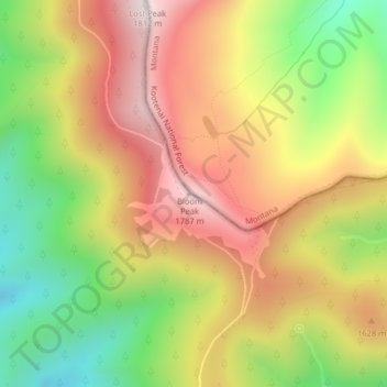
Name: Bloom Peak topographic map, elevation, terrain.
Location: Bloom Peak, Sanders County, Montana, United States (47.75488 -115.83050 47.75498 -115.83040)
Average elevation: 4,934 ft
Minimum elevation: 3,855 ft
Maximum elevation: 5,935 ft
Montana trails, hiking, mountain biking, running and outdoor activities
Make a donation
Gear up for your next adventure:
As an Amazon Associate, this site earns from qualifying purchases at no extra cost to you.
Other topographic maps
Click on a map to view its topography, its elevation and its terrain.
Make a donation
Gear up for your next adventure:
As an Amazon Associate, this site earns from qualifying purchases at no extra cost to you.
Blackfeet Indian Reservation
Elevations in the reservation range from a low of 3,400 feet (1,000 m) to a high of 9,066 feet (2,763 m) at Chief Mountain. Adjacent mountains include Ninaki Mountain and Papoose. The eastern part of the reservation is mostly open hills of grassland, while a narrow strip along the western edge is covered by…
Average elevation: 4,613 ft
Make a donation
Gear up for your next adventure:
As an Amazon Associate, this site earns from qualifying purchases at no extra cost to you.
Make a donation
Gear up for your next adventure:
As an Amazon Associate, this site earns from qualifying purchases at no extra cost to you.
Chester
United States > Montana > Liberty County
Lake Elwell, 15 miles (24 km) southwest of Chester, offer opportunities for boating, skiing, camping, picnicking, and both freshwater fishing and ice fishing. Fishing and floating are also available on the Marias River downstream from Tiber Dam. The Sweet Grass Hills to the north are the highest elevation…
Average elevation: 3,146 ft
Make a donation
Gear up for your next adventure:
As an Amazon Associate, this site earns from qualifying purchases at no extra cost to you.
Make a donation
Gear up for your next adventure:
As an Amazon Associate, this site earns from qualifying purchases at no extra cost to you.
Make a donation
Gear up for your next adventure:
As an Amazon Associate, this site earns from qualifying purchases at no extra cost to you.
Make a donation
Gear up for your next adventure:
As an Amazon Associate, this site earns from qualifying purchases at no extra cost to you.
Neihart
United States > Montana > Cascade County
The town has a total area of 1.99 square miles (5.15 km2), all land. Its elevation is 5,661 feet (1,725 m). Neihart is on U.S. Route 89, also known as the Kings Hill Scenic Byway. Snow removal crews work throughout the winter to keep the road open. It is the only town between Monarch to the north and White…
Average elevation: 6,447 ft
Make a donation
Gear up for your next adventure:
As an Amazon Associate, this site earns from qualifying purchases at no extra cost to you.
Boulder
United States > Montana > Jefferson County
Boulder lies at an elevation of 4,990 feet (1,521 m) above sea level along Interstate 15 at its intersection with Montana Highway 69, approximately 35 miles (56 km) north of Butte, and 27 miles (43 km) south of Helena. The town is on the north bank of the Boulder River, a tributary of the Jefferson River.…
Average elevation: 4,957 ft
Make a donation
Gear up for your next adventure:
As an Amazon Associate, this site earns from qualifying purchases at no extra cost to you.
Make a donation
Gear up for your next adventure:
As an Amazon Associate, this site earns from qualifying purchases at no extra cost to you.
Make a donation
Gear up for your next adventure:
As an Amazon Associate, this site earns from qualifying purchases at no extra cost to you.
Make a donation
Gear up for your next adventure:
As an Amazon Associate, this site earns from qualifying purchases at no extra cost to you.
Colstrip
United States > Montana > Rosebud County
South of town 23 miles (37 km), is Deer Medicine Rocks, a National Historic Landmark. These sandstone cliffs are covered with petroglyphs and pictographs. Hills covered in sandstone formations are typical of this area. The topography in the county is mostly rolling with small hills. Deer and pronghorn are…
Average elevation: 3,304 ft
Make a donation
Gear up for your next adventure:
As an Amazon Associate, this site earns from qualifying purchases at no extra cost to you.
Harlowton
United States > Montana > Wheatland County
The Upper Musselshell River Valley is named for the Musselshell River, which got its name from the large number of freshwater mussels found in its river bed. In the fall and winter weather, the bison would migrate to the lower altitudes along the Musselshell River. Early plains hunters, taking advantage of the…
Average elevation: 4,219 ft
Make a donation
Gear up for your next adventure:
As an Amazon Associate, this site earns from qualifying purchases at no extra cost to you.
Make a donation
Gear up for your next adventure:
As an Amazon Associate, this site earns from qualifying purchases at no extra cost to you.
Judith Gap
United States > Montana > Wheatland County
Because of its topography and prevailing winds, Judith Gap is the site of one of the most ambitious wind power projects in the United States. The 90 wind turbines at the Judith Gap Wind Farm have a nameplate capacity of 135 MW.
Average elevation: 4,613 ft
Cut Bank
United States > Montana > Glacier County
Cut Bank experiences a semi-arid climate (Köppen BSk), with long, cold, dry winters and short, warm, wetter summers. In winter, bitterly cold arctic air masses move south and impact the eastern side of the American Continental Divide. During such invasions, Cut Bank, with its comparatively high elevation and…
Average elevation: 3,763 ft
Berkeley Pit
United States > Montana > Silver Bow County > Butte
The mine is at 46°00′56″N 112°30′37″W / 46.01556°N 112.51028°W / 46.01556; -112.51028, at an altitude of 4,698 feet (1432 m) above mean sea level.
Average elevation: 5,614 ft
Make a donation
Gear up for your next adventure:
As an Amazon Associate, this site earns from qualifying purchases at no extra cost to you.
Make a donation
Gear up for your next adventure:
As an Amazon Associate, this site earns from qualifying purchases at no extra cost to you.
Make a donation
Gear up for your next adventure:
As an Amazon Associate, this site earns from qualifying purchases at no extra cost to you.
Cook Lake
United States > Montana > Custer County > Miles City > Smiths Trailer Court
Average elevation: 2,365 ft
Huntley
United States > Montana > Yellowstone County
During the Yellowstone Flood of 1937, the damage to Huntley was more extensive, percentage-wise, than in any other community in the region. Much of the original town of Huntley was destroyed and significant portions of the land it occupied was claimed or compromised by the Yellowstone River. The flood damage…
Average elevation: 3,031 ft
Make a donation
Gear up for your next adventure:
As an Amazon Associate, this site earns from qualifying purchases at no extra cost to you.
Big Sky Dam
United States > Montana > Madison County > Big Sky > Big Sky Mountain Village
Average elevation: 7,726 ft
Make a donation
Gear up for your next adventure:
As an Amazon Associate, this site earns from qualifying purchases at no extra cost to you.
Make a donation
Gear up for your next adventure:
As an Amazon Associate, this site earns from qualifying purchases at no extra cost to you.
Make a donation
Gear up for your next adventure:
As an Amazon Associate, this site earns from qualifying purchases at no extra cost to you.
North Swan Valley Wildlife Management Area
United States > Montana > Lake County
Average elevation: 4,039 ft
Make a donation
Gear up for your next adventure:
As an Amazon Associate, this site earns from qualifying purchases at no extra cost to you.
Rocky Boy's Agency
United States > Montana > Hill County > Rocky Boy's Agency
Average elevation: 3,930 ft
Make a donation
Gear up for your next adventure:
As an Amazon Associate, this site earns from qualifying purchases at no extra cost to you.