
柏合街道 topographic map
Interactive map
Click on the map to display elevation.
About this map
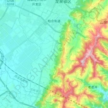
Name: 柏合街道 topographic map, elevation, terrain.
Location: 柏合街道, 龙泉驿区, 成都市, 四川省, 610105, 中国 (30.46349 104.18144 30.55374 104.30913)
Average elevation: 2,005 ft
Minimum elevation: 1,558 ft
Maximum elevation: 3,386 ft
Other topographic maps
Click on a map to view its topography, its elevation and its terrain.