
Make a donation
Gear up for your next adventure:
As an Amazon Associate, this site earns from qualifying purchases at no extra cost to you.
Belgium topographic map
Click on the map to display elevation.
Make a donation
Gear up for your next adventure:
As an Amazon Associate, this site earns from qualifying purchases at no extra cost to you.
Belgium
Belgium's topography is characterized by three distinct regions: the coastal plain in the northwest, the central plateau, and the Ardennes uplands in the southeast. The coastal plain features sand dunes and polders—low-lying tracts of land reclaimed from the sea and protected by dikes. Moving inland, the central plateau presents a gently rising landscape with fertile valleys, numerous waterways, and occasional caves and small gorges. The Ardennes region is more rugged, with densely forested hills and plateaus, rocky terrain, and elevations reaching up to 694 meters (2,277 feet) at Signal de Botrange, the country's highest point. This area extends into northern France and Germany, where it is known as the Eifel.
Make a donation
Gear up for your next adventure:
As an Amazon Associate, this site earns from qualifying purchases at no extra cost to you.
About this map
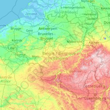
Name: Belgium topographic map, elevation, terrain.
Location: Belgium (49.49698 2.38891 51.55078 6.40810)
Average elevation: 453 ft
Minimum elevation: -30 ft
Maximum elevation: 2,280 ft
Make a donation
Gear up for your next adventure:
As an Amazon Associate, this site earns from qualifying purchases at no extra cost to you.
Other topographic maps
Click on a map to view its topography, its elevation and its terrain.
Baltimore
Baltimore exhibits a diverse topography that plays a significant role in its character and development. Situated along the Patapsco River, which flows into the Chesapeake Bay, the city is positioned on the fall line that separates the Piedmont Plateau to the west from the Atlantic Coastal Plain to the east.…
Average elevation: 213 ft
San Francisco Bay Area
United States > California > San Francisco
The San Francisco Bay Area is characterized by a diverse and dynamic topography shaped by geological processes over millions of years. This region features a combination of coastal plains, steep hills, and rugged mountains, all influenced by the tectonic activity associated with the nearby San Andreas Fault…
Average elevation: 371 ft
South America
South America's topography is marked by remarkable diversity and dramatic contrasts. The continent is dominated by the Andes mountain range, which runs along its western edge, stretching over 4,300 miles from Venezuela to Chile. These mountains are home to some of the highest peaks in the Western Hemisphere,…
Average elevation: 928 ft
City of London
United Kingdom > England > City of London > City of London
The elevation of the City ranges from sea level at the Thames to 21.6 metres (71 ft) at the junction of High Holborn and Chancery Lane. Two small but notable hills are within the historic core, Ludgate Hill to the west and Cornhill to the east. Between them ran the Walbrook, one of the many "lost" rivers or…
Average elevation: 138 ft
Make a donation
Gear up for your next adventure:
As an Amazon Associate, this site earns from qualifying purchases at no extra cost to you.
Kathmandu
Nepal > Bagmati Province > Kathmandu
Kathmandu is located at an elevation of approximately 4,600 feet (1,400 meters) within the Kathmandu Valley. This valley is characterized by a bowl-like topography, encircled by the lower Himalayan ranges, which rise sharply in the north, culminating in peaks that exceed 24,000 feet (7,300 meters). The…
Average elevation: 5,046 ft
Flagstaff
United States > Arizona > Coconino County
Flagstaff, located in Coconino County, Arizona, is characterized by its diverse topography, primarily shaped by its high elevation and volcanic activity. Sitting at around 7,000 feet (approximately 2,130 meters), the city is surrounded by the expansive Coconino National Forest, which features a blend of…
Average elevation: 7,139 ft
Himalayas
Nepal > Koshi Province > Solukhumbu
The Himalayas present a dramatic and varied topography characterized by towering peaks, deep valleys, and extensive glaciers. This majestic mountain range features some of the highest elevations on Earth, including Mount Everest, which rises to 29,035 feet. The terrain is marked by steep, jagged ridges and…
Average elevation: 24,787 ft
Make a donation
Gear up for your next adventure:
As an Amazon Associate, this site earns from qualifying purchases at no extra cost to you.
Scottish Highlands
United Kingdom > Scotland > Highland
The Scottish Highlands are renowned for their rugged, mountainous terrain that dominates much of the region. Stretching across the northern and central parts of Scotland, the landscape is shaped by ancient geological forces, including the Caledonian Orogeny, which caused significant tectonic collisions…
Average elevation: 2,976 ft
Make a donation
Gear up for your next adventure:
As an Amazon Associate, this site earns from qualifying purchases at no extra cost to you.
North America
North America's topography is characterized by its diverse and dramatic landscapes, stretching from the towering Rocky Mountains in the west to the expansive Great Plains in the central region, and the rugged Appalachian Mountains in the east. The Rocky Mountains, which include peaks exceeding 20,000 feet…
Average elevation: 965 ft
Mount Fuji
Japan > Sunto County > Oyama
Mount Fuji (富士山, Fujisan, Japanese: [ɸɯꜜ(d)ʑisaɴ] (listen)), or Fugaku, located on the island of Honshū, is the highest mountain in Japan, with a summit elevation of 3,776.24 m (12,389 ft 3 in). It is the second-highest volcano located on an island in Asia (after Mount Kerinci on the island of…
Average elevation: 10,709 ft
Make a donation
Gear up for your next adventure:
As an Amazon Associate, this site earns from qualifying purchases at no extra cost to you.
Indianapolis
United States > Indiana > Indianapolis
Indianapolis is within the Tipton Till Plain, a flat to gently sloping terrain underlain by glacial deposits known as till. The lowest point in the city is about 650 feet (198 m) above mean sea level, with the highest natural elevation at about 900 feet (274 m) above sea level. Few hills or short ridges, known…
Average elevation: 791 ft
Hudson
United States > Florida > Hudson
Hudson features a predominantly flat and low-lying topography typical of the region, with an average elevation of approximately 16 feet above sea level. This terrain is interspersed with various wetlands and small lakes, creating a rich ecosystem that supports diverse wildlife. The area also includes a few…
Average elevation: 16 ft
Make a donation
Gear up for your next adventure:
As an Amazon Associate, this site earns from qualifying purchases at no extra cost to you.
Port Charlotte
United States > Florida > Charlotte County
Port Charlotte is characterized by a predominantly flat and low-lying terrain, typical of Florida’s coastal landscape. The area features a network of waterways, including the Peace River and Charlotte Harbor, which provide ample opportunities for recreational activities like boating and fishing. Elevations…
Average elevation: 13 ft
Santa Cruz Mountains
United States > California > Santa Clara County
The Santa Cruz Mountains are a region of great biological diversity, encompassing cool, moist coastal ecosystems as well as warm, dry chaparral. Much of the area in the Santa Cruz mountains is considered temperate rainforest. In valleys and moist ocean-facing slopes some of the southernmost coast redwoods…
Average elevation: 755 ft
Make a donation
Gear up for your next adventure:
As an Amazon Associate, this site earns from qualifying purchases at no extra cost to you.
Great Plains
United States > Kansas > Thomas County
The North American Environmental Atlas, produced by the Commission for Environmental Cooperation, a NAFTA agency composed of the geographical agencies of the Mexican, American, and Canadian governments, uses the "Great Plains" as an ecoregion synonymous with predominant prairies and grasslands rather than as…
Average elevation: 3,356 ft
Ga-Masemola
South Africa > Limpopo > Sekhukhune District Municipality > Makhuduthamaga Local Municipality
Average elevation: 2,989 ft
Make a donation
Gear up for your next adventure:
As an Amazon Associate, this site earns from qualifying purchases at no extra cost to you.
Ramona
United States > California > San Diego County
In January 2006, Ramona Valley was designated the country's 162nd American Viticultural Area (AVA) by the Alcohol and Tobacco Tax and Trade Bureau, which recognized the area for its distinctive microclimate, elevation, and soil attributes.
Average elevation: 1,539 ft
Appalachian Mountains
United States > North Carolina > Yancey County
The Appalachian Mountains (French: Appalaches), often called the Appalachians, are a system of mountains in eastern to northeastern North America. The Appalachians first formed roughly 480 million years ago during the Ordovician Period. They once reached elevations similar to those of the Alps and the Rocky…
Average elevation: 4,800 ft
Palm Harbor
United States > Florida > Pinellas County
Palm Harbor is characterized by its unique topography, which features a relatively rare hilly landscape for the region. Unlike much of the surrounding areas in Pinellas County, which are predominantly flat, Palm Harbor includes elevations that can reach up to about 75 feet above sea level. This elevation gives…
Average elevation: 30 ft
Make a donation
Gear up for your next adventure:
As an Amazon Associate, this site earns from qualifying purchases at no extra cost to you.
Istanbul
Istanbul, located in northwestern Turkey, is a city that is uniquely situated across two continents, Europe and Asia, divided by the Bosphorus Strait. The city’s topography is characterized by a complex blend of hills, valleys, and coastal plains, which create a varied and scenic landscape. The European side…
Average elevation: 187 ft
Make a donation
Gear up for your next adventure:
As an Amazon Associate, this site earns from qualifying purchases at no extra cost to you.
Mount Etna
During the first 1500 years AD, many eruptions went unrecorded (or records have been lost); among the more significant are: (1) an eruption in about 1030 AD near Monte Ilice on the lower southeast flank, which produced a lava flow that travelled about 10 km, reaching the sea north of Acireale; the villages of…
Average elevation: 3,796 ft
Make a donation
Gear up for your next adventure:
As an Amazon Associate, this site earns from qualifying purchases at no extra cost to you.
Parrish
United States > Florida > Manatee County
Parrish features a predominantly flat terrain with an average elevation of approximately 36 feet above sea level. The area's landscape is characterized by gently rolling hills and low-lying regions, making it typical of the Central Florida topography. Surrounding Parrish are numerous wetlands and drainage…
Average elevation: 39 ft
Virginia Beach
United States > Virginia > Virginia Beach
Virginia Beach, Virginia, located in the coastal region of the United States, features a predominantly flat terrain characterized by its proximity to the Atlantic Ocean. The elevation is remarkably low, averaging about 10 feet (3 meters) above sea level, which contributes to the area's susceptibility to…
Average elevation: 7 ft
Make a donation
Gear up for your next adventure:
As an Amazon Associate, this site earns from qualifying purchases at no extra cost to you.
Johannesburg
United States > California > Kern County
Johannesburg is a census-designated place (CDP) in Kern County, California, in a mining district of the Rand Mountains. Johannesburg is located 1 mile (1.6 km) east-northeast of Randsburg, at an elevation of 3,517 feet (1,072 m). The terminus of the Randsburg Railway was here from 1897 to 1933. The population…
Average elevation: 3,619 ft
Cincinnati
United States > Ohio > Hamilton County
Cincinnati has several standard modes of transportation including sidewalks, roads, public transit, bicycle paths and airports. The city's hills preclude the regular street grid common to many cities built up in the 19th century, and outside of the downtown basin, regular street grids are rare except for in…
Average elevation: 738 ft
Make a donation
Gear up for your next adventure:
As an Amazon Associate, this site earns from qualifying purchases at no extra cost to you.
Latitude Margaritaville
United States > South Carolina > Jasper County > Hardeeville
Average elevation: 13 ft
Make a donation
Gear up for your next adventure:
As an Amazon Associate, this site earns from qualifying purchases at no extra cost to you.
Lipa
Philippines > Batangas > Lipa > Lipa
At the celebration of the elevation of Lipa to a city in January 1888, José Rizal was invited by Dr. Jose Lozada, Catalino Dimayuga and the brothers Celestino and Simeon Luz but Rizal responded only with his Hymno Al Trabajo which he dedicated to the zeal and industry of the Lipeños.
Average elevation: 535 ft
Nokomis
United States > Florida > Sarasota County
Nokomis features a predominantly flat and low-lying terrain characteristic of the coastal region. The elevation in Nokomis rarely exceeds 15 feet above sea level, contributing to its vulnerability to tidal influences and storm surges. The area is interspersed with wetlands and mangroves, particularly near the…
Average elevation: 16 ft
Make a donation
Gear up for your next adventure:
As an Amazon Associate, this site earns from qualifying purchases at no extra cost to you.
Las Cruces
United States > New Mexico > Doña Ana County > Las Cruces
The approximate elevation of Las Cruces is 3,908 feet (1,191 m) above sea level.
Average elevation: 4,314 ft
Make a donation
Gear up for your next adventure:
As an Amazon Associate, this site earns from qualifying purchases at no extra cost to you.
Salt Lake City
United States > Utah > Salt Lake County > Salt Lake City
Salt Lake City has an area of 110.4 square miles (286 km2) and an average elevation of 4,327 feet (1,319 m) above sea level. The lowest point within the boundaries of the city is 4,210 feet (1,280 m) near the Jordan River and the Great Salt Lake, and the highest is Grandview Peak, at 9,410 feet (2,868 m).
Average elevation: 5,331 ft
Bozeman
United States > Montana > Gallatin County
Bozeman is located at an elevation of 4,820 feet (1,470 m). The Bridger Mountains are to the north-northeast, the Tobacco Root Mountains to the west-southwest, the Big Belt Mountains and Horseshoe Hills to the northwest, the Hyalite Peaks of the northern Gallatin Range to the south and the Spanish Peaks of the…
Average elevation: 5,509 ft
Make a donation
Gear up for your next adventure:
As an Amazon Associate, this site earns from qualifying purchases at no extra cost to you.
Sonoran Desert
United States > Arizona > Pima County
To the north in California and northwest Arizona, the Sonoran Desert transitions to the colder-winter, higher-elevation Mojave, Great Basin, and Colorado Plateau deserts.
Average elevation: 1,696 ft
Lutz
United States > Florida > Hillsborough County > Tampa
Lutz is characterized by a gently rolling topography that showcases the distinctive features of the central Florida landscape. The area has an average elevation of about 70 feet (21 meters) above sea level, contributing to its mild undulations rather than dramatic elevation changes. The terrain is marked by a…
Average elevation: 66 ft
Make a donation
Gear up for your next adventure:
As an Amazon Associate, this site earns from qualifying purchases at no extra cost to you.
Twentynine Palms
United States > California > Twentynine Palms
According to the United States Census Bureau, the city has a total area of 59.1 square miles (153 km2), all land. The city is at an elevation of 1,988 feet (606 m). The Marine Corps Air Ground Combat Center Twentynine Palms is located there.
Average elevation: 2,264 ft
Make a donation
Gear up for your next adventure:
As an Amazon Associate, this site earns from qualifying purchases at no extra cost to you.
Fairbanks
United States > Alaska > Fairbanks North Star
Fairbanks is situated within the central Tanana Valley, characterized by a diverse and dynamic topography. The city straddles the Chena River, which flows southwest into the larger Tanana River, defining Fairbanks' southern border. To the north, a gradual incline leads into a chain of hills that ascend toward…
Average elevation: 479 ft
Zagros Mountains
Iran > Isfahan Province > Semirom County > Padena-ye Vosta RD
Average elevation: 12,618 ft
Make a donation
Gear up for your next adventure:
As an Amazon Associate, this site earns from qualifying purchases at no extra cost to you.
East Texas
United States > Pennsylvania > Lehigh County > Lower Macungie Township
Average elevation: 413 ft
San Diego
United States > California > San Diego County > San Diego
The climate in San Diego, like most of Southern California, often varies significantly over short geographical distances, resulting in microclimates. In San Diego, this is mostly because of the city's topography (the Bay, and the numerous hills, mountains, and canyons). Frequently, particularly during the "May…
Average elevation: 187 ft
Englewood
United States > Florida > Sarasota County
Englewood features predominantly flat and low-lying terrain typical of the region's coastal landscape. The average elevation here is approximately 15 feet above sea level, which makes the area particularly susceptible to tidal influences and storm surges. The terrain is interspersed with wetlands and…
Average elevation: 10 ft
Make a donation
Gear up for your next adventure:
As an Amazon Associate, this site earns from qualifying purchases at no extra cost to you.
Grand Canyon
United States > Arizona > Coconino County
Uplift associated with mountain formation later moved these sediments thousands of feet upward and created the Colorado Plateau. The higher elevation has also resulted in greater precipitation in the Colorado River drainage area, but not enough to change the Grand Canyon area from being semi-arid. The uplift…
Average elevation: 3,356 ft
Make a donation
Gear up for your next adventure:
As an Amazon Associate, this site earns from qualifying purchases at no extra cost to you.
Hot Springs National Park
United States > Arkansas > Garland County > Hot Springs
The National Park Service exercises no control or supervision over any matters connected with the city. The city starts on the other side of Central Avenue from Bathhouse Row. Its development has extended beyond the narrow valley in which the springs are located, spreading out over the open plain to the south…
Average elevation: 745 ft
La Jolla
United States > California > San Diego County > San Diego > La Jolla
Average elevation: 121 ft
Africa
Africa's topography is a complex tapestry of plateaus, mountains, valleys, and deserts. The continent is dominated by vast plateaus, with elevations averaging around 1,000 meters (3,281 feet), especially prominent in the south and east. The Ethiopian Highlands, often referred to as the "Roof of Africa," rise…
Average elevation: 1,516 ft
Make a donation
Gear up for your next adventure:
As an Amazon Associate, this site earns from qualifying purchases at no extra cost to you.
Mexico City
Mexico > Mexico City > Mexico City
Mexico City is located in the Valley of Mexico, sometimes called the Basin of Mexico. This valley is located in the Trans-Mexican Volcanic Belt in the high plateaus of south-central Mexico. It has a minimum altitude of 2,200 meters (7,200 feet) above sea level and is surrounded by mountains and volcanoes that…
Average elevation: 7,615 ft
Englewood
Englewood features a diverse topography characterized by flat coastal plains and gently rolling terrain. The area is predominantly low-lying, with elevations rarely exceeding 20 feet above sea level, making it susceptible to tidal influences from the Gulf of Mexico. The landscape is interspersed with wetlands,…
Average elevation: 10 ft
Ponte Vedra Beach
United States > Florida > Saint Johns County > Ponte Vedra Beach
Ponte Vedra Beach is characterized by its gently rolling terrain that is primarily flat and lies only about 15 feet above sea level. The landscape is predominantly shaped by coastal dunes and the proximity to the Atlantic Ocean, resulting in sandy beaches interspersed with vegetation typical of barrier island…
Average elevation: 10 ft
Fairhope
United States > Alabama > Baldwin County > Fairhope
According to the U.S. Census Bureau, the city has a total area of 12.0 square miles (31.1 km2), of which 0.019 square mile (0.05 km2), or 0.16%, is water. Its elevation ranges from sea level at the bay to 122 feet (37 m) in the city center.
Average elevation: 115 ft
Make a donation
Gear up for your next adventure:
As an Amazon Associate, this site earns from qualifying purchases at no extra cost to you.
Greenfield Hill
United States > Connecticut > Greater Bridgeport Planning Region > Fairfield
Average elevation: 174 ft
Johnston Island
The climate is tropical but generally dry. Northeast trade winds are consistent and there is little seasonal temperature variation. With elevation ranging from sea level to 5 m (16 ft) at Summit Peak, the islands contain some low-growing vegetation and palm trees on mostly flat terrain, and no natural fresh…
Average elevation: 3 ft
Make a donation
Gear up for your next adventure:
As an Amazon Associate, this site earns from qualifying purchases at no extra cost to you.
Anna Maria island
United States > Florida > Manatee County
Anna Maria Island features a flat, sandy topography typical of a barrier island on the Gulf Coast. With an average elevation of around 15 feet above sea level, the terrain includes broad beaches, low dunes, and narrow stretches of sandy soil, making it highly vulnerable to storm surges and tidal flooding. The…
Average elevation: 7 ft
Dallas
United States > Texas > Dallas County
Dallas and its surrounding area are mostly flat. The city lies at elevations ranging from 450 to 550 feet (137 to 168 m) above sea level. The western edge of the Austin Chalk Formation, a limestone escarpment (also known as the "White Rock Escarpment"), rises 230 feet (70 m) and runs roughly north–south…
Average elevation: 518 ft
Make a donation
Gear up for your next adventure:
As an Amazon Associate, this site earns from qualifying purchases at no extra cost to you.