
Make a donation
Gear up for your next adventure:
As an Amazon Associate, this site earns from qualifying purchases at no extra cost to you.
Africa topographic map
Click on the map to display elevation.
Make a donation
Gear up for your next adventure:
As an Amazon Associate, this site earns from qualifying purchases at no extra cost to you.
Africa
Africa's topography is a complex tapestry of plateaus, mountains, valleys, and deserts. The continent is dominated by vast plateaus, with elevations averaging around 1,000 meters (3,281 feet), especially prominent in the south and east. The Ethiopian Highlands, often referred to as the "Roof of Africa," rise to formidable heights, with peaks such as Ras Dejen reaching 4,550 meters (14,928 feet). The Great Rift Valley, a significant geological feature, stretches from the Red Sea down to Mozambique, creating deep depressions hosting some of Africa's largest lakes, including Lake Tanganyika and Lake Malawi, and marked by volcanic mountains such as Mount Kilimanjaro, Africa's highest point at 5,895 metres (19,341 ft) and Mount Kenya. In the northwest, the Atlas Mountains extend through Morocco, Algeria, and Tunisia, with Mount Toubkal standing as the range's highest point at 4,167 meters (13,671 feet). Contrasting these elevations, the Sahara Desert sprawls across North Africa, characterized by expansive sand dunes and rocky plateaus. The southern part of Africa includes the Kalahari Desert and the Drakensberg Mountains, which rise steeply from the plains. This diverse terrain influences the continent's climate, biodiversity, and human settlements.
Make a donation
Gear up for your next adventure:
As an Amazon Associate, this site earns from qualifying purchases at no extra cost to you.
About this map
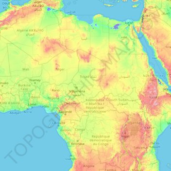
Name: Africa topographic map, elevation, terrain.
Location: Africa (-13.49757 -7.24219 36.50243 42.75781)
Average elevation: 1,516 ft
Minimum elevation: -1,362 ft
Maximum elevation: 14,554 ft
Make a donation
Gear up for your next adventure:
As an Amazon Associate, this site earns from qualifying purchases at no extra cost to you.
Other topographic maps
Click on a map to view its topography, its elevation and its terrain.
United States
The topography of the United States is characterized by diverse and dynamic landscapes that vary widely across the country. In the east, rolling hills and low mountains transition into the Appalachian Mountains, featuring peaks that generally reach around 6,000 feet (1,829 meters). Moving westward, the terrain…
Average elevation: 1,014 ft
Sarasota
United States > Florida > Sarasota County
Sarasota is characterized by predominantly flat topography with an average elevation of about 25 feet (approximately 8 meters) above sea level. The area features gently rolling terrain and is primarily composed of coastal plains. These low-lying regions are interspersed with wetlands and several small lakes,…
Average elevation: 23 ft
New York
New York City's topography is a fascinating blend of varied elevations and unique landscapes, reflecting its diverse geography across five boroughs. Situated at the confluence of the Hudson and East Rivers, the city primarily features low-lying terrain, with the average elevation hovering around sea level.…
Average elevation: 62 ft
Seattle
United States > Washington > King County
Seattle features a diverse topography characterized by its unique geographical setting between Puget Sound and Lake Washington. The city is situated on an isthmus, which contributes to its dramatic landscape, featuring rolling hills and steep slopes that rise abruptly from the waterfront. The average elevation…
Average elevation: 131 ft
Make a donation
Gear up for your next adventure:
As an Amazon Associate, this site earns from qualifying purchases at no extra cost to you.
Arizona
Arizona's topography is highly diverse, shaped by three distinct regions: the Colorado Plateau, the Basin and Range Province, and the Transition Zone. The northern Colorado Plateau is characterized by flat, high plains over 4,000 feet in elevation, including the Grand Canyon and its breathtaking cliffs. In…
Average elevation: 4,032 ft
San Francisco
San Francisco is characterized by its striking and varied topography, making it one of the most distinctive cities in the United States. The landscape features a mix of rolling hills and steep inclines, with the highest elevation reaching approximately 922 feet at Twin Peaks. The average elevation across the…
Average elevation: 213 ft
California
California's topography is characterized by a remarkable diversity that includes expansive mountain ranges, deep valleys, and vast deserts. The Sierra Nevada mountains dominate the eastern part of the state, with peaks such as Mount Whitney rising to 14,494 feet (4,418 meters), making it the tallest point in…
Average elevation: 3,048 ft
Florida
Florida's topography is characterized by its predominantly flat landscape, with the highest elevation being Britton Hill at just 345 feet (105 meters) above sea level, making it the lowest high point of any U.S. state. The state is primarily divided into three physiographic regions: the Atlantic Coastal Plain,…
Average elevation: 20 ft
Make a donation
Gear up for your next adventure:
As an Amazon Associate, this site earns from qualifying purchases at no extra cost to you.
Oregon
Oregon's topography is strikingly diverse, characterized by an array of geographical features that shape its unique landscape. The state is framed by two significant mountain ranges: the Pacific Coast Range to the west and the Cascade Mountains running north to south through the center. This mountainous…
Average elevation: 3,077 ft
Ohio
Ohio's topography is characterized by a diverse landscape that ranges from the flat plains in the north to the rolling hills and rugged terrain in the southeast. The state can be divided into several distinct regions, including the Great Lakes Plains to the north, the Central Plains in the west, and the…
Average elevation: 912 ft
Texas
Texas showcases a diverse and expansive topography that spans approximately 268,000 square miles (694,117 Km²), making it the second-largest state in the United States. The landscape ranges from the arid deserts of West Texas, characterized by broad valleys and mesas, to the rolling hills of the Texas Hill…
Average elevation: 1,699 ft
Austin
United States > Texas > Travis County
Austin features a diverse and varied topography shaped by its position along the Balcones Fault. The city’s elevation ranges from about 425 feet to approximately 1,000 feet above sea level, creating a landscape characterized by rolling hills and elevated areas particularly in the western regions. To the…
Average elevation: 709 ft
Make a donation
Gear up for your next adventure:
As an Amazon Associate, this site earns from qualifying purchases at no extra cost to you.
Dallas
United States > Texas > Dallas County
Dallas features a predominantly flat terrain characterized by elevations generally ranging from 450 to 550 feet (137 to 168 meters) above sea level. The landscape is shaped significantly by the western edge of the Austin Chalk Formation, a limestone escarpment known as the White Rock Escarpment, which rises…
Average elevation: 525 ft
Portland
United States > Oregon > Multnomah County
Portland features a striking and varied topography characterized by its location at the confluence of the Willamette and Columbia Rivers. The city lies within the fertile Willamette Valley, flanked by the snow-capped Cascade Mountains to the east, including the prominent Mount Hood, and the less elevated…
Average elevation: 253 ft
San Diego
United States > California > San Diego County
San Diego is characterized by a diverse topography that features coastal plains, rolling hills, and rugged mountain ranges. The city is situated along the Pacific Ocean, where it boasts an extensive shoreline with sandy beaches and tidal zones. As you move inland, the landscape transitions from the flat…
Average elevation: 410 ft
Michigan
Michigan's topography is characterized by a diverse landscape that transitions from flat plains to rugged hills. The state comprises two peninsulas, with the Upper Peninsula showcasing more pronounced elevation changes, including its highest point, Mount Arvon, which rises to 1,979 feet (603 meters). In…
Average elevation: 850 ft
Make a donation
Gear up for your next adventure:
As an Amazon Associate, this site earns from qualifying purchases at no extra cost to you.
Denver
United States > Colorado > Denver County > Denver
Denver, situated at an elevation of 5,280 feet (1,609 meters), is renowned as the "Mile High City." It is located in the South Platte River Valley, just east of the Rocky Mountains' foothills. The city's topography features a gently sloping landscape characterized by rolling hills and wide valleys,…
Average elevation: 5,525 ft
Missouri
Missouri's topography is marked by a diverse array of landforms that contribute to its unique landscape. The state is characterized by four main physiographic regions: the Ozark Plateau, Dissected Till Plains, Mississippi Alluvial Plain, and the Osage Plains. The Ozark Plateau, located in the south, features…
Average elevation: 827 ft
Pittsburgh
United States > Pennsylvania > Allegheny County
Pittsburgh, located in Allegheny County, Pennsylvania, is characterized by its distinct and varied topography, shaped by the confluence of the Allegheny, Monongahela, and Ohio rivers. The city itself is situated at an average elevation of approximately 764 feet (233 meters) above sea level, with the terrain…
Average elevation: 994 ft
Colorado
Colorado's topography is characterized by a diverse range of elevations and landforms, making it one of the most geologically varied states in the U.S. The state is dominated by the Rocky Mountains, which run north to south and include the highest peak in the contiguous United States, Mount Elbert, towering at…
Average elevation: 6,759 ft
Make a donation
Gear up for your next adventure:
As an Amazon Associate, this site earns from qualifying purchases at no extra cost to you.
Phoenix
United States > Arizona > Maricopa County
Phoenix is characterized by a unique topographical landscape nestled in the Salt River Valley. This valley, at an average elevation of about 1,086 feet, is framed by several prominent mountain ranges, creating a striking contrast between the flat plains and elevated terrains. Notable peaks such as Camelback…
Average elevation: 1,578 ft
Tennessee
Tennessee features a diverse and varied topography characterized by its distinct regions, which include the Appalachian Mountains, the Central Basin, and the Gulf Coastal Plain. The state’s highest point is Clingmans Dome, rising to about 6,643 feet (2,025 meters) above sea level, while the lowest point is…
Average elevation: 764 ft
Virginia
Virginia's topography is characterized by a diverse landscape that transitions from the Atlantic Coastal Plain in the east to the mountainous regions in the west. The Coastal Plain features flat, low-lying areas that gradually rise to the Piedmont, known for its rolling hills and valleys. Further west, the…
Average elevation: 814 ft
Philadelphia
United States > Pennsylvania > Philadelphia County
Philadelphia, located at the confluence of the Delaware and Schuylkill Rivers, features a diverse topography characterized by its gentle slopes and valleys. The city lies on the Atlantic Seaboard Fall Line, transitioning from the flat Coastal Plain to the more rugged Piedmont region. This unique geographical…
Average elevation: 144 ft
Make a donation
Gear up for your next adventure:
As an Amazon Associate, this site earns from qualifying purchases at no extra cost to you.
Saint Petersburg
United States > Florida > Pinellas County
Saint Petersburg features a predominantly flat topography characteristic of the Gulf Coast region. The city's elevation averages around 44 feet (approximately 13.4 meters) above sea level, with some areas dipping to about 15 feet (4.6 meters). This relatively low elevation contributes to the area's…
Average elevation: 13 ft
Houston
United States > Texas > Harris County
Houston is characterized by its predominantly flat topography, sitting at an average elevation of approximately 59 feet (18 meters) above sea level. The city is situated on the Gulf Coastal Plain, which is dissected by a network of bayous that contribute to the region's drainage. This terrain was once covered…
Average elevation: 82 ft
Tampa
United States > Florida > Hillsborough County
Tampa is characterized by a predominantly flat topography, with an average elevation around 16 to 49 feet (5 to 15 meters) above sea level. The terrain is marked by low-lying areas and gentle slopes, with the highest points in the vicinity reaching approximately 62 feet (19 meters). This landscape is…
Average elevation: 36 ft
Chicago
United States > Illinois > Cook County
Chicago is characterized by its predominantly flat terrain, with an average elevation of about 579 feet (176 meters) above sea level. The city's landscape is primarily shaped by its proximity to Lake Michigan to the east, which influences local weather and provides a scenic waterfront. While the central areas…
Average elevation: 597 ft
Make a donation
Gear up for your next adventure:
As an Amazon Associate, this site earns from qualifying purchases at no extra cost to you.
Atlanta
United States > Georgia > Fulton County
Atlanta features a varied topography characterized by its rolling hills and elevated terrain. The city sits at an average elevation of approximately 1,050 feet (320 meters) above sea level, with elevations ranging from about 725 feet (221 meters) to 1,175 feet (358 meters) in the surrounding areas. This…
Average elevation: 932 ft
North Carolina
North Carolina features a diverse topography that can be divided into three distinct regions: the Coastal Plain, the Piedmont, and the Appalachian Mountains. The Coastal Plain, which occupies the eastern part of the state, is characterized by flat and gently sloping land, with elevations typically less than…
Average elevation: 535 ft
Pennsylvania
Pennsylvania's topography is characterized by its rich diversity, ranging from the rugged Appalachian Mountains in the south to the flatlands of the northern plateau. The state's elevation varies significantly, with the highest point being Mount Davis at approximately 3,213 feet (979 meters) and the lowest at…
Average elevation: 1,115 ft
Bend
United States > Oregon > Deschutes County
Bend is characterized by its distinctive topography, situated at an elevation of approximately 3,623 feet (1,105 meters) above sea level. The city lies within the high desert region of Central Oregon, bordered by the Cascade Mountains to the west, which provide a dramatic backdrop with peaks like the Three…
Average elevation: 3,678 ft
Make a donation
Gear up for your next adventure:
As an Amazon Associate, this site earns from qualifying purchases at no extra cost to you.
Georgia
Georgia's topography is notably diverse, characterized by five main geographic regions that each contribute to its unique landscape. The southern part of the state features the Coastal Plain, a flat, low-lying area that gently slopes toward the Atlantic Ocean and is home to the expansive Okefenokee Swamp, one…
Average elevation: 446 ft
Minneapolis
United States > Minnesota > Hennepin County
Minneapolis is characterized by a diverse and dynamic topography. The city sits at an average elevation of approximately 830 feet (253 meters) above sea level, but this varies significantly across its landscape. The terrain is predominantly flat, interspersed with rolling hills, and is marked by the presence…
Average elevation: 886 ft
Charlotte
United States > North Carolina > Mecklenburg County
Charlotte, located in the Piedmont region of North Carolina, features a gently rolling terrain characterized by elevations ranging from approximately 650 to 700 feet (198 to 213 meters). The city is bordered to the west by the Catawba River, which contributes to the area's mild climate and lush vegetation.…
Average elevation: 679 ft
Kansas City
United States > Missouri > Jackson County
Kansas City features a diverse topography characterized by rolling hills and valleys, with elevations ranging from about 794 to 997 feet above sea level. The landscape is shaped by the confluence of the Missouri and Kansas rivers, resulting in a mix of elevated areas and flat river plains. The region's average…
Average elevation: 909 ft
Make a donation
Gear up for your next adventure:
As an Amazon Associate, this site earns from qualifying purchases at no extra cost to you.
Salt Lake City
United States > Utah > Salt Lake County
Salt Lake City's topography is characterized by a striking contrast between its flat valley floor and the surrounding rugged mountains. The city is situated in the Salt Lake Valley, with an average elevation of approximately 4,237 feet above sea level, making it one of the higher major cities in the United…
Average elevation: 5,223 ft
Manhattan
United States > New York > New York County > New York
Manhattan, a densely populated urban island, has a diverse topography characterized by its generally flat terrain interspersed with elevated areas. The average elevation is about 50 feet (15 meters) above sea level, with its highest point reaching approximately 265 feet (81 meters) at Bennett Park in…
Average elevation: 52 ft
Alaska
Alaska's topography is characterized by dramatic contrasts, featuring a diverse array of mountainous regions, vast plains, and intricate coastlines. The Alaska Range, home to Denali, rises to an elevation of 20,310 feet, making it the highest peak in North America. This mountain range exhibits significant…
Average elevation: 679 ft
Bellingham
United States > Washington > Whatcom County
Bellingham is characterized by a diverse and striking topography that combines coastal and mountainous landscapes. The city lies along the eastern shore of Bellingham Bay, where the waters of the Puget Sound meet the foothills of the Cascade Range. Rising abruptly from the shoreline, the surrounding hills and…
Average elevation: 292 ft
Make a donation
Gear up for your next adventure:
As an Amazon Associate, this site earns from qualifying purchases at no extra cost to you.
Miami
United States > Florida > Miami-Dade County
Miami is characterized by its unique topography, which features a broad coastal plain lying between the expansive Everglades to the west and the tranquil waters of Biscayne Bay to the east. The average elevation across the city is approximately 16 feet (5 meters) above sea level, with some areas dipping…
Average elevation: 16 ft
San Antonio
United States > Texas > Bexar County
San Antonio features a diverse topography characterized by gently rolling hills and flat plains. The city's elevation averages around 650 feet above sea level, but nearby areas can reach heights of up to 1,300 feet in certain locations like Cross Mountain. The landscape is part of the southern edge of the…
Average elevation: 810 ft
Denver
Denver is characterized by its diverse topography that combines both high plains and mountain ranges. The city itself sits at an elevation of 5,280 feet (1,609 meters), marking it as the "Mile High City." To the east, the landscape transitions into the High Plains, which extend toward the Kansas border,…
Average elevation: 5,525 ft
Alabama
Alabama's topography is characterized by a diverse and intricate landscape that varies significantly across its regions. In the northern and northeastern parts, the terrain features the hilly and mountainous Appalachian Highlands, including the notable Cheaha Mountain, which rises to an elevation of 2,407 feet…
Average elevation: 446 ft
Make a donation
Gear up for your next adventure:
As an Amazon Associate, this site earns from qualifying purchases at no extra cost to you.
Mexico City
Mexico City is situated in the Valley of Mexico, an expansive highland region characterized by a unique and varied topography. The city itself rests at an elevation of approximately 7,350 feet (2,240 meters) above sea level, surrounded by formidable mountain ranges, including the Sierra de Guadalupe to the…
Average elevation: 8,593 ft
Cleveland
United States > Ohio > Cuyahoga County
Cleveland features a diverse topography shaped significantly by its proximity to Lake Erie and the Cuyahoga River. The city is characterized by a rapid elevation change, with the lakefront sitting at approximately 569 feet above sea level. Just inland, Public Square rises to about 650 feet, while further from…
Average elevation: 705 ft
Tallahassee
United States > Florida > Leon County
Tallahassee features a distinctive topography that is characterized by hilly terrain, which is somewhat atypical for the generally flat landscape of the state. The city is located at the southern end of the Red Hills Region and just above the Cody Scarp, with elevations ranging from about 7 feet near its low…
Average elevation: 118 ft
Kentucky
Kentucky's topography is characterized by a diverse landscape that varies significantly across its regions. The state features rolling hills, plateaus, and mountainous areas, particularly in the eastern section where the Cumberland Plateau rises to the highest point at Black Mountain, which reaches 4,139 feet…
Average elevation: 991 ft
Make a donation
Gear up for your next adventure:
As an Amazon Associate, this site earns from qualifying purchases at no extra cost to you.
Panama
Panama's topography is characterized by a striking diversity of landscapes that range from rugged mountains to expansive lowland plains. The interior of the country features the Central Cordillera, which includes some of the highest peaks such as Volcán Barú, reaching an elevation of about 11,400 feet (3,475…
Average elevation: 299 ft
China
China's topography is characterized by dramatic contrasts, presenting a varied landscape that can be understood as a three-step staircase ascending from east to west. The eastern lowlands feature vast, fertile plains, such as the North China Plain and the Middle-Lower Yangtze Plain, which are vital…
Average elevation: 2,956 ft
Colorado Springs
United States > Colorado > El Paso County
Colorado Springs boasts a diverse and striking topography characterized by its high elevation and mountainous terrain. Nestled at approximately 6,035 feet (1,839 meters) above sea level, the city is flanked by the majestic Pikes Peak, which rises dramatically to 14,115 feet (4,302 meters), forming part of the…
Average elevation: 7,388 ft
Tulsa
United States > Oklahoma > Tulsa
Tulsa, located in northeastern Oklahoma, is characterized by a diverse and rolling topography that marks its transition from the Great Plains to the Ozark foothills. The city's elevation averages around 700 feet (approximately 210 meters) above sea level, with some areas reaching heights of up to 1,050 feet…
Average elevation: 725 ft
Make a donation
Gear up for your next adventure:
As an Amazon Associate, this site earns from qualifying purchases at no extra cost to you.
Charleston
United States > South Carolina > Charleston County
Charleston is characterized by its relatively flat topography, with an average elevation of about 10 feet above sea level, making it prone to flooding during heavy rains and storms. The city is situated on a peninsula bordered by the Ashley River to the west and the Cooper River to the east, creating a natural…
Average elevation: 13 ft
Wisconsin
Wisconsin's topography is characterized by a diverse landscape shaped by glacial activity, resulting in a mixture of rolling hills, flat plains, and numerous lakes. The state’s highest point is Timms Hill, reaching an elevation of 1,952 feet (595 meters), while its lowest point is the shore of Lake Michigan…
Average elevation: 988 ft
Peru
Peru's topography is strikingly diverse, shaped by the Andes mountain range that runs through the center of the country, splitting the landscape into three distinct regions: the coastal desert, the Andean highlands, and the Amazon basin. The coastal region is marked by arid, desert-like terrain, with dramatic…
Average elevation: 2,116 ft
Chattanooga
United States > Tennessee > Hamilton County
Chattanooga showcases a diverse and striking topography that is defined by its position within the Appalachian region. Nestled between the rugged Ridge-and-Valley Appalachians and the Cumberland Plateau, the city is framed by dramatic hills and valleys, creating a visually compelling landscape. The Tennessee…
Average elevation: 1,086 ft
Make a donation
Gear up for your next adventure:
As an Amazon Associate, this site earns from qualifying purchases at no extra cost to you.
Indiana
Indiana's topography is characterized by gently rolling hills, primarily in the central and southern regions, and flat plains in the north. The state's average elevation is around 650 feet, with the highest point being Hoosier Hill at approximately 1,257 feet, located in Wayne County. The lowest elevation,…
Average elevation: 741 ft
Idaho
Idaho's topography is characterized by its remarkable diversity, featuring vast mountain ranges, deep river canyons, and extensive plains. The state is home to over 75 mountain ranges, including the prominent Rocky Mountains and the majestic Sawtooth Range, with peaks like Borah Peak rising to 12,662 feet…
Average elevation: 5,030 ft
Nashville
United States > Tennessee > Davidson County
Nashville-Davidson, features a diverse topography characterized by its position in the Nashville Basin and the Highland Rim. The terrain is predominantly hilly, with elevations ranging from approximately 385 feet at the Cumberland River to around 1,163 feet in areas like Radnor Lake State Natural Area. This…
Average elevation: 604 ft
Milwaukee
United States > Wisconsin > Milwaukee County
Milwaukee County is characterized by a gently rolling landscape that transitions into flatter terrain as it approaches Lake Michigan. The region's elevation varies modestly, with most areas ranging from about 600 to 700 feet above sea level. The county features several prominent water bodies, including the…
Average elevation: 673 ft
Make a donation
Gear up for your next adventure:
As an Amazon Associate, this site earns from qualifying purchases at no extra cost to you.
Utah
Utah's topography is characterized by a stunning variety of landscapes, reflecting its geological complexity and rich natural history. The state is primarily shaped by the Colorado Plateau and the Basin and Range province, resulting in a diverse terrain that includes rugged mountain ranges, deep canyons, and…
Average elevation: 6,155 ft
Louisiana
Louisiana's topography is defined by a variety of landscapes that reflect both its coastal and inland characteristics. Much of the state consists of low-lying plains, including the Mississippi Alluvial Plain, where the fertile soils of the delta create an area vital for agriculture. The eastern region near the…
Average elevation: 128 ft
Pinellas County
Pinellas County features a predominantly flat terrain, characterized by low-lying coastal plains that rise gently from the shores of the Gulf of Mexico. The highest points in the county reach around 60 feet above sea level, primarily found in the northern sections. The area is interspersed with numerous water…
Average elevation: 13 ft
San Jose
United States > California > Santa Clara County
San Jose, located in Santa Clara County, California, features a diverse topography characterized by a mix of low-lying plains and rolling hills. The city sits at an average elevation of approximately 82 feet (25 meters) above sea level, with the surrounding terrain including the foothills of the Santa Cruz…
Average elevation: 869 ft
Make a donation
Gear up for your next adventure:
As an Amazon Associate, this site earns from qualifying purchases at no extra cost to you.
Iran
Iran's topography is diverse and dominated by rugged mountain ranges, which define much of its landscape. To the west, the Zagros Mountains stretch from the northwest to the southeast, with many peaks surpassing 10,000 feet (3,048 meters) in elevation. These mountains form a rugged barrier between Iran's…
Average elevation: 2,579 ft
San Marcos
United States > Texas > Hays County
San Marcos is characterized by its diverse topography, which includes rolling hills, lush riverbanks, and scenic limestone outcroppings. The city is situated at an elevation of approximately 600 feet above sea level, providing a backdrop of gently undulating terrain that slopes towards the banks of the San…
Average elevation: 682 ft
Raleigh
United States > North Carolina > Wake County
Raleigh features a topography primarily defined by its position along the fall line, which is the geological boundary between the Piedmont and Coastal Plain regions. This area experiences a gradual elevation drop of approximately 150 to 350 feet over a distance of 1 to 3 miles as one moves eastward. The city's…
Average elevation: 338 ft
Flagstaff
United States > Arizona > Coconino County
Flagstaff, located in Coconino County, Arizona, is characterized by its diverse topography, primarily shaped by its high elevation and volcanic activity. Sitting at around 7,000 feet (approximately 2,130 meters), the city is surrounded by the expansive Coconino National Forest, which features a blend of…
Average elevation: 7,139 ft
Make a donation
Gear up for your next adventure:
As an Amazon Associate, this site earns from qualifying purchases at no extra cost to you.
New Orleans
United States > Louisiana > Orleans Parish
New Orleans is situated on relatively flat terrain, primarily at or slightly below sea level, with the average elevation around 6 feet above sea level. The city's landscape is characterized by a network of wetlands, rivers, and bayous, which play a crucial role in its ecology and urban planning. It lies within…
Average elevation: 3 ft
Saint Augustine
United States > Florida > Saint Johns County
Saint Augustine is characterized by a diverse topography that features a mix of coastal and inland landscapes. Situated along the eastern coast of the state, the city lies on a narrow peninsula bordered by the Atlantic Ocean to the east and the Matanzas River to the west. The area includes sandy beaches that…
Average elevation: 16 ft
Yellowstone National Park
Yellowstone National Park's topography is characterized by a remarkable diversity of geological features shaped by its unique volcanic history and tectonic activity. The park is predominantly situated on the Yellowstone Plateau, which is part of the larger Rocky Mountain range, with elevations ranging from…
Average elevation: 8,038 ft
Cincinnati
United States > Ohio > Hamilton County
Cincinnati features a distinctive topography characterized by its rolling hills and valleys. The city is situated on the north bank of the Ohio River, where the terrain rises sharply from the riverfront, reaching elevations of approximately 980 feet (299 meters) in some areas. The average elevation throughout…
Average elevation: 728 ft
Make a donation
Gear up for your next adventure:
As an Amazon Associate, this site earns from qualifying purchases at no extra cost to you.
Cape Coral
United States > Florida > Lee County
Cape Coral is characterized by its predominantly flat and low-lying terrain, with an average elevation of around 13 feet (4 meters) above sea level. The area's topography features a network of canals, with over 400 miles of navigable waterways, making it one of the most waterway-dense cities globally. The…
Average elevation: 13 ft
New Mexico
New Mexico's topography is strikingly diverse, characterized by a mix of high mountain ranges, arid plains, and expansive desert regions. The state is primarily defined by the Rocky Mountains, which run north to south through its central region, featuring peaks that reach over 13,000 feet, such as Wheeler…
Average elevation: 5,535 ft
Southern California
Most of Southern California has a Mediterranean-like climate, with warm and dry summers, mild and wet winters, where cool weather and freezing temperatures are rare. Southern California contains other types of climates, including semi-arid, desert and mountain, with infrequent rain and many sunny days. Summers…
Average elevation: 1,900 ft
Adirondack Park
Adirondack Park, covering over six million acres, features a diverse topography characterized by rugged mountains, extensive forests, and numerous waterways. The park is dominated by the Adirondack Mountains, which contain 46 peaks exceeding 4,000 feet, with Mount Marcy standing at 5,343 feet as the highest…
Average elevation: 1,217 ft
Make a donation
Gear up for your next adventure:
As an Amazon Associate, this site earns from qualifying purchases at no extra cost to you.
Reno
United States > Nevada > Washoe County
Reno is characterized by its diverse topography, which is shaped by its elevation and the surrounding mountain ranges. Situated at an average elevation of approximately 4,500 feet (about 1,370 meters), the city is nestled in a high desert region that features a mix of flat valleys and gently rolling hills.…
Average elevation: 5,413 ft
Springfield
United States > Missouri > Greene County
Springfield is situated on a gently rolling plateau at an average elevation of approximately 1,310 feet (400 meters) above sea level. The region is characterized by a mix of flatlands and gradual slopes that rise toward the nearby Ozark Mountains, which can be found to the south and east. The local terrain…
Average elevation: 1,276 ft
Massachusetts
Massachusetts features a diverse and varied topography. The western part of the state is dominated by the Berkshire Hills and Taconic Mountains, including Mount Greylock, the highest point at 3,491 feet (1,064 meters). The central region is marked by rolling hills, part of the broader New England Upland, which…
Average elevation: 420 ft
Fayetteville
United States > Arkansas > Washington County
Fayetteville is nestled in the picturesque Ozark Mountains, characterized by rolling hills, lush forests, and scenic valleys that define the region's topography. The elevation in Fayetteville ranges from about 1,100 feet to over 1,500 feet above sea level, creating a varied landscape that features steep ridges…
Average elevation: 1,316 ft
Make a donation
Gear up for your next adventure:
As an Amazon Associate, this site earns from qualifying purchases at no extra cost to you.
Wyoming
Wyoming's topography is characterized by a dramatic and varied landscape that includes vast mountain ranges, expansive plateaus, and intermontane basins. The state is predominantly mountainous, with the Rocky Mountains covering a significant portion of its western region. Here, the Wind River Range rises to…
Average elevation: 6,358 ft
Oakland
United States > California > Alameda County
Oakland features a diverse topography shaped by its location along the eastern shore of San Francisco Bay and the presence of the nearby coastal hills. The city sits on a flat coastal plain that gradually ascends toward the Oakland Hills to the east, where elevations can exceed 1,700 feet. The highest point…
Average elevation: 167 ft
Asheville
United States > North Carolina > Buncombe County
Asheville, located in Buncombe County, North Carolina, is characterized by a diverse and picturesque topography primarily shaped by its position within the Blue Ridge Mountains. The city itself sits at an elevation of approximately 2,200 feet, surrounded by peaks that rise significantly higher, such as Mount…
Average elevation: 2,385 ft
Gainesville
United States > Florida > Alachua County
Gainesville is situated in a region characterized by gently rolling hills and a mix of flatlands, typical of north-central Florida's terrain. The elevation ranges from approximately 50 to 200 feet above sea level, providing a scenic landscape dotted with lush vegetation and various waterways, including the…
Average elevation: 138 ft
Make a donation
Gear up for your next adventure:
As an Amazon Associate, this site earns from qualifying purchases at no extra cost to you.
Puerto Rico
Puerto Rico features a diverse topography characterized by a mountainous interior, coastal plains, and stunning beaches. The island's central region is dominated by the Cordillera Central mountain range, which includes the highest peak, Cerro de Punta, rising to 4,390 feet (1,338 meters). These mountains…
Average elevation: 213 ft
Orlando
United States > Florida > Orange County
Orlando features a predominantly flat terrain characterized by gentle hills and low-lying areas, with elevations typically ranging from 50 to 100 feet above sea level. Despite its overall flatness, the topography includes marshes and wetlands due to the presence of numerous lakes and rivers, contributing to a…
Average elevation: 95 ft
Los Angeles
United States > California > Los Angeles County
Los Angeles is characterized by a diverse and dynamic topography. The city is predominantly situated in a basin bordered by mountain ranges, including the Santa Monica Mountains to the north and the San Gabriel Mountains to the east, with elevations reaching up to about 10,000 feet (3,048 meters) in certain…
Average elevation: 791 ft
Make a donation
Gear up for your next adventure:
As an Amazon Associate, this site earns from qualifying purchases at no extra cost to you.
South Carolina
South Carolina's topography is defined by three major geographic regions: the Atlantic Coastal Plain, the Piedmont, and the Blue Ridge Mountains. Covering approximately two-thirds of the state, the Atlantic Coastal Plain is characterized by flat, gently rolling terrain that transitions from the sandy beaches…
Average elevation: 279 ft
Sarasota County
Sarasota County, located along Florida's Gulf Coast, features a predominantly flat terrain typical of coastal regions. The county's elevation averages around 20 feet above sea level, with its lowest areas near the coastline and slightly higher inland regions. Much of the land consists of coastal plains,…
Average elevation: 23 ft
Make a donation
Gear up for your next adventure:
As an Amazon Associate, this site earns from qualifying purchases at no extra cost to you.
Kansas
Kansas features a diverse yet subtle topography shaped by its position within the Great Plains. The eastern regions exhibit rolling hills and fertile soil, characterized by the Dissected Till Plains and Flint Hills, where prairie grasses thrive on rocky terrain. As you move westward, the land gradually ascends…
Average elevation: 1,972 ft
Omaha
United States > Nebraska > Douglas County
Omaha features a varied topography characterized by rolling hills and valleys that rise gently from the Missouri River, which forms the city's eastern boundary. The landscape is primarily composed of prairie and hardwood forests, offering a mix of open spaces and wooded areas. Elevations within the city range…
Average elevation: 1,109 ft
Clearwater
United States > Florida > Pinellas County
Clearwater, situated on the western coast of Florida, features a relatively flat topography typical of the Gulf Coast region. The city lies at an average elevation of around 30 feet above sea level, characterized by gently rolling terrain that transitions smoothly into the expansive beaches along the Gulf of…
Average elevation: 26 ft
New Hampshire
New Hampshire's topography is characterized by a diverse landscape that ranges from its towering mountains to its serene lakes and rolling hills. Dominated by the White Mountains, the highest point in the state is Mount Washington, reaching an elevation of 6,288 feet, while the average elevation across New…
Average elevation: 961 ft
Make a donation
Gear up for your next adventure:
As an Amazon Associate, this site earns from qualifying purchases at no extra cost to you.
Montana
Montana's topography is marked by dramatic contrasts, offering a rich tapestry of landscapes. The state is divided into three main regions: the vast, rolling plains in the east, the rugged Rocky Mountains in the west, and the transition zone between these two. The eastern plains are part of the Great Plains,…
Average elevation: 4,452 ft
Connecticut
Connecticut's topography is a diverse landscape characterized by a mix of mountainous regions, lowlands, and coastal areas. The state can be broadly divided into five geographical regions: the Taconic Section, which features the highest point in Connecticut at Bear Mountain (2,380 feet / 725 meters), has steep…
Average elevation: 387 ft
Rocky Mountain National Park
United States > Colorado > Larimer County
Rocky Mountain National Park is one of the highest national parks in the nation, with elevations from 7,860 to 14,259 feet (2,396 to 4,346 m), the highest point of which is Longs Peak. Trail Ridge Road is the highest paved through-road in the country, with a peak elevation of 12,183 feet (3,713 m). Sixty…
Average elevation: 10,082 ft
Make a donation
Gear up for your next adventure:
As an Amazon Associate, this site earns from qualifying purchases at no extra cost to you.