
Make a donation
Gear up for your next adventure:
As an Amazon Associate, this site earns from qualifying purchases at no extra cost to you.
Gauteng topographic map
Click on the map to display elevation.
Make a donation
Gear up for your next adventure:
As an Amazon Associate, this site earns from qualifying purchases at no extra cost to you.
Gauteng
Gauteng's southern border is the Vaal River, which separates it from the Free State. It also borders on North West to the west, Limpopo to the north, and Mpumalanga to the east. Gauteng is the only landlocked province of South Africa without a foreign border. Most of Gauteng is on the Highveld, a high-altitude grassland (circa 1,500 m or 4,921 ft above sea level). Between Johannesburg and Pretoria, there are low parallel ridges and undulating hills, some part of the Magaliesberg Mountains and the Witwatersrand. The north of the province is more subtropical, due to its lower altitude and is mostly dry savanna habitat.
Make a donation
Gear up for your next adventure:
As an Amazon Associate, this site earns from qualifying purchases at no extra cost to you.
About this map
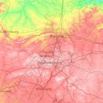
Name: Gauteng topographic map, elevation, terrain.
Location: Gauteng, South Africa (-26.92383 27.15634 -25.10961 29.09842)
Average elevation: 4,610 ft
Minimum elevation: 2,999 ft
Maximum elevation: 6,250 ft
Make a donation
Gear up for your next adventure:
As an Amazon Associate, this site earns from qualifying purchases at no extra cost to you.
Other topographic maps
Click on a map to view its topography, its elevation and its terrain.
Johannesburg
South Africa > Gauteng > City of Johannesburg Metropolitan Municipality
Johannesburg is located in the eastern plateau area of South Africa known as the Highveld, at an elevation of 1,753 metres (5,751 ft). The former Central Business District is located on the southern side of the prominent ridge called the Witwatersrand (English: White Water's Ridge) and the terrain falls to the…
Average elevation: 5,299 ft
Pretoria
South Africa > Gauteng > City of Tshwane Metropolitan Municipality
Pretoria is situated approximately 55 km (34 mi) north-northeast of Johannesburg in the northeast of South Africa, in a transitional belt between the plateau of the Highveld to the south and the lower-lying Bushveld to the north. It lies at an altitude of about 1,339 m (4,393 ft) above sea level, in a warm,…
Average elevation: 4,472 ft
KuGompo City
South Africa > Eastern Cape > Buffalo City Metropolitan Municipality
Average elevation: 236 ft
Make a donation
Gear up for your next adventure:
As an Amazon Associate, this site earns from qualifying purchases at no extra cost to you.
Johannesburg
South Africa > Gauteng > City of Johannesburg Metropolitan Municipality
Johannesburg is located in the eastern plateau area of South Africa known as the Highveld, at an elevation of 1,753 metres (5,751 ft). The former Central Business District is located on the southern side of the prominent ridge called the Witwatersrand (English: White Water's Ridge) and the terrain falls to the…
Average elevation: 5,299 ft
Bloemfontein
South Africa > Free State > Mangaung Metropolitan Municipality
Situated at an elevation of 1,395 m (4,577 ft) above sea level, the city is home to approximately 520,000 residents and forms part of the Mangaung Metropolitan Municipality which has a population of 747,431. It was one of the host cities for the 2010 FIFA World Cup.
Average elevation: 4,508 ft
Cape Town
South Africa > Western Cape > City of Cape Town
The Cape Peninsula is 52 km long from Mouille Point in the north to Cape Point in the south, with an area of about 470 km2, and it displays more topographical variety than other similar sized areas in southern Africa, and consequently spectacular scenery. There are diverse low-nutrient soils, large rocky…
Average elevation: 174 ft
Make a donation
Gear up for your next adventure:
As an Amazon Associate, this site earns from qualifying purchases at no extra cost to you.
Cape Town
South Africa > Western Cape > City of Cape Town
The Cape Peninsula is 52 km long from Mouille Point in the north to Cape Point in the south, with an area of about 470 km2, and it displays more topographical variety than other similar sized areas in southern Africa, and consequently spectacular scenery. There are diverse low-nutrient soils, large rocky…
Average elevation: 174 ft
Bothaville
South Africa > Free State > Lejweleputswa District Municipality > Nala Local Municipality
Average elevation: 4,222 ft
Jeffreys Bay
South Africa > Eastern Cape > Sarah Baartman District Municipality > Kouga Local Municipality
Average elevation: 98 ft
Vaal Dam
South Africa > Free State > Fezile Dabi District Municipality > Metsimaholo Local Municipality > Deneysville
Average elevation: 4,859 ft
Make a donation
Gear up for your next adventure:
As an Amazon Associate, this site earns from qualifying purchases at no extra cost to you.
Durbanville
South Africa > Western Cape > City of Cape Town
Durbanville is situated in the northern suburbs of Cape Town, approximately 28 kilometres (17.4 mi) north-east of the city, bordered by Bellville to the south, Brackenfell to the south-east and Kraaifontein to the east. It lies at an altitude of between 100 m (328 ft) to 240 m (787 ft), in the vast rolling…
Average elevation: 515 ft
Masodi
South Africa > Limpopo > Waterberg District Municipality > Mogalakwena Local Municipality
Average elevation: 3,517 ft
Stellenbosch
South Africa > Western Cape > Cape Winelands District Municipality > Stellenbosch Local Municipality
Stellenbosch is 53 km (33 mi) east of Cape Town via National Route N1. Stellenbosch is in a hilly region of the Cape Winelands, and is sheltered in a valley at an average elevation of 136 m (446 ft), flanked on the west by Papegaaiberg (Afrikaans: Parrot Mountain), which is actually a hill. To the south is…
Average elevation: 728 ft
Make a donation
Gear up for your next adventure:
As an Amazon Associate, this site earns from qualifying purchases at no extra cost to you.
Ulundi
South Africa > KwaZulu-Natal > Zululand District Municipality > Ulundi Local Municipality
Average elevation: 1,923 ft
Lusikisiki
South Africa > Eastern Cape > O.R. Tambo District Municipality > Ingquza Hill Local Municipality
Average elevation: 1,847 ft
Danville
South Africa > Gauteng > City of Tshwane Metropolitan Municipality > Pretoria
Average elevation: 4,432 ft
Umdloti / eMdloti
South Africa > KwaZulu-Natal > eThekwini Metropolitan Municipality
eMdloti has a permanent population of around 3,000 people but can increase by as much as tenfold during the Christmas and Easter holiday season. Due to eMdloti's single access road (M27) from the M4/N2 interchanges, the topography, the fact that North and South Beach Roads are both cul-de-sacs and limited…
Average elevation: 125 ft
Make a donation
Gear up for your next adventure:
As an Amazon Associate, this site earns from qualifying purchases at no extra cost to you.
Madadeni
South Africa > KwaZulu-Natal > Amajuba District Municipality > Newcastle Local Municipality
Average elevation: 3,924 ft
Evaton
South Africa > Gauteng > Sedibeng District Municipality > Emfuleni Local Municipality
Average elevation: 4,993 ft
Gqeberha
South Africa > Eastern Cape > Nelson Mandela Bay Metropolitan Municipality
Average elevation: 121 ft
Make a donation
Gear up for your next adventure:
As an Amazon Associate, this site earns from qualifying purchases at no extra cost to you.
Pietermaritzburg
South Africa > KwaZulu-Natal > uMgungundlovu District Municipality
Average elevation: 2,799 ft
Phalaborwa
South Africa > Limpopo > Mopani District Municipality > Ba-Phalaborwa Local Municipality
Average elevation: 1,375 ft
Make a donation
Gear up for your next adventure:
As an Amazon Associate, this site earns from qualifying purchases at no extra cost to you.
Eshowe
South Africa > KwaZulu-Natal > King Cetswayo District Municipality > uMlalazi Local Municipality
Average elevation: 1,499 ft
Nigel
South Africa > Gauteng > City of Ekurhuleni Metropolitan Municipality
Average elevation: 5,151 ft
Umlazi
South Africa > KwaZulu-Natal > eThekwini Metropolitan Municipality
Umlazi is situated on a series of undulating hills at an average elevation of 101 metres above sea level between the uMlaza River to the north and the uMbokodweni River to the south. Another river running through Umlazi is the Siphingo River which also runs towards the south of the township.
Average elevation: 328 ft
Make a donation
Gear up for your next adventure:
As an Amazon Associate, this site earns from qualifying purchases at no extra cost to you.
Phuthaditjhaba
South Africa > Free State > Thabo Mofutsanyana District Municipality > Maluti-a-Phofung Local Municipality
Average elevation: 5,696 ft
Emmarentia Dam
South Africa > Gauteng > City of Johannesburg Metropolitan Municipality > Johannesburg
Average elevation: 5,285 ft
Stutterheim
South Africa > Eastern Cape > Amathole District Municipality > Amahlathi Local Municipality
Average elevation: 2,736 ft
Make a donation
Gear up for your next adventure:
As an Amazon Associate, this site earns from qualifying purchases at no extra cost to you.
Stellenbosch
South Africa > Western Cape > Cape Winelands District Municipality > Stellenbosch Local Municipality
Stellenbosch is 53 km (33 mi) east of Cape Town via National Route N1. Stellenbosch is in a hilly region of the Cape Winelands, and is sheltered in a valley at an average elevation of 136 m (446 ft), flanked on the west by Papegaaiberg (Afrikaans: Parrot Mountain), which is actually a hill. To the south is…
Average elevation: 942 ft
Franschhoek
South Africa > Western Cape > Cape Winelands District Municipality > Stellenbosch Local Municipality
Average elevation: 1,647 ft
Howick
South Africa > KwaZulu-Natal > uMgungundlovu District Municipality > uMgeni Local Municipality
Howick is possibly the location of the first crewed flight in the world. Evidence exists that a John Goodman Household flew a self made glider in 1871 and again in 1875 on the outskirts of Howick, close to Karkloof. The actual distance flown and altitude achieved differs from source to source (some sources say…
Average elevation: 3,497 ft
Umkomaas
South Africa > KwaZulu-Natal > eThekwini Metropolitan Municipality
The Umkomaas or uMkomazi River is a dominant feature of the area, being the largest river on the South Coast. The river is 298 kilometres long, from its source just south of Giant's Castle in the uKhahlamba / Drakensberg Park World Heritage Site to its mouth on the Indian Ocean. The river begins its journey at…
Average elevation: 125 ft
Make a donation
Gear up for your next adventure:
As an Amazon Associate, this site earns from qualifying purchases at no extra cost to you.
Johannesburg
South Africa > Gauteng > City of Johannesburg Metropolitan Municipality
Johannesburg is located in the eastern plateau area of South Africa known as the Highveld, at an elevation of 1,753 metres (5,751 ft). The former Central Business District is located on the southern side of the prominent ridge called the Witwatersrand (English: White Water's Ridge) and the terrain falls to the…
Average elevation: 5,299 ft
Graaff-Reinet
South Africa > Eastern Cape > Sarah Baartman District Municipality > Camdeboo Local Municipality
Average elevation: 2,864 ft
Make a donation
Gear up for your next adventure:
As an Amazon Associate, this site earns from qualifying purchases at no extra cost to you.
Kayser's Beach
South Africa > Eastern Cape > Buffalo City Metropolitan Municipality
Average elevation: 92 ft
Magaliesberg Biosphere Reserve
The reserve includes a variety of landscapes including slopes, cliffs, crests, kloofs, rivers, wetlands and valleys. Although the area covers a diverse geological area, it consists mainly of the Magaliesberg mountain complex comprising two geological formations: the Transvaal System and the Bushveld Igneous…
Average elevation: 4,482 ft
Mtititi
South Africa > Limpopo > Vhembe District Municipality > Thulamela Local Municipality
Average elevation: 1,558 ft
Make a donation
Gear up for your next adventure:
As an Amazon Associate, this site earns from qualifying purchases at no extra cost to you.
Make a donation
Gear up for your next adventure:
As an Amazon Associate, this site earns from qualifying purchases at no extra cost to you.
Fraserburg
South Africa > Northern Cape > Namakwa District Municipality > Karoo Hoogland Local Municipality
Fraserburg is situated at an altitude of 1,385 metres (4,544 ft) above sea level on a high Karoo plateau, north of the Nuweveld Mountains.
Average elevation: 4,160 ft
Klerksdorp
South Africa > North West > Dr Kenneth Kaunda District Municipality
Average elevation: 4,416 ft
Hermanus
South Africa > Western Cape > Overberg District Municipality > Overstrand Local Municipality
Average elevation: 285 ft
Centurion
South Africa > Gauteng > City of Tshwane Metropolitan Municipality
Average elevation: 4,760 ft
Make a donation
Gear up for your next adventure:
As an Amazon Associate, this site earns from qualifying purchases at no extra cost to you.
Alice
South Africa > Eastern Cape > Amathole District Municipality > Nkonkobe Local Municipality
The location was named Lovedale by European missionaries who settled there in 1824.It lies on the southwestern bank of the Tyhume River, west-northwest of East London, at an elevation of 1,720(524m).It was named after John Love of the Glasgow Missionary Society. During the Frontier War it was abandoned and the…
Average elevation: 1,923 ft
White River
South Africa > Mpumalanga > Ehlanzeni District Municipality > Mbombela
White River is located in the low altitude subtropical Lowveld climatic zone. Savannah and woodland scattered with granite outcrops form the indigenous habitat. Compared to other parts of South Africa, the climate is mild with good rainfall. Nevertheless, like the rest of South Africa, White River and its…
Average elevation: 2,959 ft
Randburg
South Africa > Gauteng > City of Johannesburg Metropolitan Municipality
Average elevation: 5,141 ft
Make a donation
Gear up for your next adventure:
As an Amazon Associate, this site earns from qualifying purchases at no extra cost to you.
Pinetown
South Africa > KwaZulu-Natal > eThekwini Metropolitan Municipality
Topographically, Pinetown is generally hilly with the exception of the central business district which is relatively flatter by comparison to the surrounding suburban areas. The notable high-lying areas in the eastern parts of Pinetown include Cowies Hill and the New Germany Nature Reserve reaching…
Average elevation: 1,168 ft
Marloth Park
South Africa > Mpumalanga > Ehlanzeni District Municipality > Nkomazi
Average elevation: 722 ft
Cullinan
South Africa > Gauteng > City of Tshwane Metropolitan Municipality
Cullinan is situated in the Highveld region of South Africa. The town has an elevation of 1476 m (4842.52 ft) and is located at −25.6709 [latitude in decimal degrees], 28.5236 [longitude in decimal degrees]. The closest city is Pretoria being 40 km (25 mi) away, while Johannesburg is 100 km (62 mi) away.
Average elevation: 4,659 ft
Ceres
South Africa > Western Cape > Cape Winelands District Municipality > Witzenberg Local Municipality
Ceres experiences a typical Mediterranean climate tempered by its altitude. The town experiences warmer temperatures in summer, due to its inland location with infrequent rainfall, however winters are cool to quite cold and wet, with frequent snowfalls on the surrounding higher-lying ground, rarely falling on…
Average elevation: 1,923 ft
Make a donation
Gear up for your next adventure:
As an Amazon Associate, this site earns from qualifying purchases at no extra cost to you.
Worcester
South Africa > Western Cape > Cape Winelands District Municipality > Breede Valley Local Municipality
Worcester is located at an elevation of 220 metres (720 ft) and can be reached by road either travelling on the N1 highway through the Huguenot Tunnel or by driving through spectacular mountain passes. From Cape Town Du Toitskloof, from Wellington Bainskloof, from Malmesbury, Western Cape Nieuwekloof, from…
Average elevation: 827 ft
Germiston
South Africa > Gauteng > City of Ekurhuleni Metropolitan Municipality
Average elevation: 5,364 ft
Springs
South Africa > Gauteng > City of Ekurhuleni Metropolitan Municipality
Average elevation: 5,269 ft
Make a donation
Gear up for your next adventure:
As an Amazon Associate, this site earns from qualifying purchases at no extra cost to you.
Hartbeespoort Dam
South Africa > North West > Bojanala Platinum District Municipality > Madibeng Local Municipality > Kosmos
Average elevation: 4,114 ft
Bethlehem
South Africa > Free State > Thabo Mofutsanyana District Municipality > Dihlabeng Local Municipality
The city lies at an altitude of 1,700 metres (5,600 ft) and this contributes to its cool climate with frosty winters and mild summers. The average annual temperature is around 14 °C (57 °F).
Average elevation: 5,495 ft
Beaufort West
South Africa > Western Cape > Central Karoo District Municipality > Beaufort West Local Municipality
Average elevation: 2,802 ft
Middelburg
South Africa > Mpumalanga > Nkangala > Steve Tshwete Local Municipality
Average elevation: 4,898 ft
Make a donation
Gear up for your next adventure:
As an Amazon Associate, this site earns from qualifying purchases at no extra cost to you.
Pretoria
South Africa > Gauteng > City of Tshwane Metropolitan Municipality
Pretoria is situated approximately 55 km (34 mi) north-northeast of Johannesburg in the northeast of South Africa, in a transitional belt between the plateau of the Highveld to the south and the lower-lying Bushveld to the north. It lies at an altitude of about 1,339 m (4,393 ft) above sea level, in a warm,…
Average elevation: 4,472 ft
Loskop Dam
South Africa > Mpumalanga > Nkangala > Steve Tshwete Local Municipality
Average elevation: 3,973 ft
Bizana
South Africa > Eastern Cape > Alfred Nzo District Municipality > Mbizana Local Municipality
Average elevation: 2,700 ft
Make a donation
Gear up for your next adventure:
As an Amazon Associate, this site earns from qualifying purchases at no extra cost to you.
Leeupoort Vakansiedorp
South Africa > Limpopo > Waterberg District Municipality > Thabazimbi Local Municipality
Average elevation: 3,566 ft
Robertson
South Africa > Western Cape > Cape Winelands District Municipality > Langeberg Local Municipality
Average elevation: 817 ft
Mahikeng
South Africa > North West > Ngaka Modiri Molema District Municipality
Close to South Africa's border with Botswana, Mafikeng is 1,400 km (870 mi) northeast of Cape Town and 260 km (160 mi) west of Johannesburg. In 2001 it had a population of 49,300. In 2007 Mafikeng was reported to have a population of 250,000, of which the CBD constituted between 69,000 and 75,000. It is built…
Average elevation: 4,334 ft
Osizweni
South Africa > KwaZulu-Natal > Amajuba District Municipality > Newcastle Local Municipality
Average elevation: 3,983 ft
Make a donation
Gear up for your next adventure:
As an Amazon Associate, this site earns from qualifying purchases at no extra cost to you.
Stanford
South Africa > Western Cape > Overberg District Municipality > Overstrand Local Municipality
Average elevation: 351 ft
Nkowankowa
South Africa > Limpopo > Mopani District Municipality > Greater Tzaneen Local Municipality
Average elevation: 1,785 ft
Hopefield
South Africa > Western Cape > West Coast District Municipality > Saldanha Bay Local Municipality
Average elevation: 190 ft
Modjadjiskloof
South Africa > Limpopo > Mopani District Municipality > Greater Letaba Local Municipality
Average elevation: 3,182 ft
Make a donation
Gear up for your next adventure:
As an Amazon Associate, this site earns from qualifying purchases at no extra cost to you.
Letlhabile
South Africa > North West > Bojanala Platinum District Municipality > Moses Kotane Local Municipality
Average elevation: 3,727 ft
Carletonville
South Africa > Gauteng > West Rand District Municipality > Merafong City Local Municipality
Average elevation: 5,049 ft
Blaaupan Dam
South Africa > Gauteng > City of Ekurhuleni Metropolitan Municipality
Average elevation: 5,433 ft
Umbumbulu
South Africa > KwaZulu-Natal > eThekwini Metropolitan Municipality
Average elevation: 1,663 ft
Make a donation
Gear up for your next adventure:
As an Amazon Associate, this site earns from qualifying purchases at no extra cost to you.
Lambert's Bay
South Africa > Western Cape > West Coast District Municipality > Cederberg Local Municipality
Average elevation: 62 ft
Modderfontein
South Africa > Gauteng > Sedibeng District Municipality > Midvaal Local Municipality
Average elevation: 5,033 ft
Driekoppies Dam
South Africa > Mpumalanga > Ehlanzeni District Municipality > Nkomazi > Schulzendal
Average elevation: 1,165 ft
Make a donation
Gear up for your next adventure:
As an Amazon Associate, this site earns from qualifying purchases at no extra cost to you.
Mehlomnyama Nature Reserve
South Africa > KwaZulu-Natal > Ugu District Municipality > Umzumbe Local Municipality
Average elevation: 1,243 ft
Salt Rock
South Africa > KwaZulu-Natal > iLembe District Municipality > KwaDukuza Local Municipality
Average elevation: 118 ft
Colenso
South Africa > KwaZulu-Natal > Uthukela District Municipality > Emnambithi/Ladysmith Local Municipality
Average elevation: 3,173 ft
Make a donation
Gear up for your next adventure:
As an Amazon Associate, this site earns from qualifying purchases at no extra cost to you.
Wellington
South Africa > Western Cape > Cape Winelands District Municipality > Drakenstein Local Municipality
Average elevation: 551 ft
Manyii
South Africa > Limpopo > Vhembe District Municipality > Makhado Local Municipality
Average elevation: 2,992 ft
Vygeboom Dam
South Africa > Mpumalanga > Gert Sibande > Albert Luthuli Local Municipality
Average elevation: 3,465 ft
Make a donation
Gear up for your next adventure:
As an Amazon Associate, this site earns from qualifying purchases at no extra cost to you.