
George topographic map
Click on the map to display elevation.
About this map
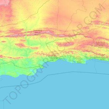
Name: George topographic map, elevation, terrain.
Location: George, Western Cape, South Africa (-34.43906 20.50315 -33.31496 23.70330)
Average elevation: 1,368 ft
Minimum elevation: -3 ft
Maximum elevation: 7,421 ft
Other topographic maps
Click on a map to view its topography, its elevation and its terrain.
Cape Town
South Africa > Western Cape > City of Cape Town
The Cape Peninsula is 52 km long from Mouille Point in the north to Cape Point in the south, with an area of about 470 km2, and it displays more topographical variety than other similar sized areas in southern Africa, and consequently spectacular scenery. There are diverse low-nutrient soils, large rocky…
Average elevation: 174 ft
Riebeek-Kasteel
South Africa > Western Cape > West Coast District Municipality > Swartland Local Municipality
Average elevation: 610 ft
Stellenbosch
South Africa > Western Cape > Cape Winelands District Municipality > Stellenbosch Local Municipality
Stellenbosch is 53 km (33 mi) east of Cape Town via National Route N1. Stellenbosch is in a hilly region of the Cape Winelands, and is sheltered in a valley at an average elevation of 136 m (446 ft), flanked on the west by Papegaaiberg (Afrikaans: Parrot Mountain), which is actually a hill. To the south is…
Average elevation: 942 ft
Stanford
South Africa > Western Cape > Overberg District Municipality > Overstrand Local Municipality
Average elevation: 351 ft
Durbanville
South Africa > Western Cape > City of Cape Town
Durbanville is situated in the northern suburbs of Cape Town, approximately 28 kilometres (17.4 mi) north-east of the city, bordered by Bellville to the south, Brackenfell to the south-east and Kraaifontein to the east. It lies at an altitude of between 100 m (328 ft) to 240 m (787 ft), in the vast rolling…
Average elevation: 515 ft
Cape Town
South Africa > Western Cape > City of Cape Town
The Cape Peninsula is 52 km long from Mouille Point in the north to Cape Point in the south, with an area of about 470 km2, and it displays more topographical variety than other similar sized areas in southern Africa, and consequently spectacular scenery. There are diverse low-nutrient soils, large rocky…
Average elevation: 174 ft
Wellington
South Africa > Western Cape > Cape Winelands District Municipality > Drakenstein Local Municipality
Average elevation: 551 ft
Langebaan
South Africa > Western Cape > West Coast District Municipality > Saldanha Bay Local Municipality
Average elevation: 112 ft
Table Mountain
South Africa > Western Cape > City of Cape Town > Cape Town
Table Mountain is at the northern end of a sandstone mountain range that forms the spine of the Cape Peninsula that terminates approximately 50 kilometres (30 mi) to the south at the Cape of Good Hope and Cape Point. Immediately to the south of Table Mountain is a rugged "plateau" at a somewhat lower elevation…
Average elevation: 1,913 ft
Durbanville
South Africa > Western Cape > City of Cape Town
Durbanville is situated in the northern suburbs of Cape Town, approximately 28 kilometres (17.4 mi) north-east of the city, bordered by Bellville to the south, Brackenfell to the south-east and Kraaifontein to the east. It lies at an altitude of between 100 m (328 ft) to 240 m (787 ft), in the vast rolling…
Average elevation: 515 ft
Hopefield
South Africa > Western Cape > West Coast District Municipality > Saldanha Bay Local Municipality
Average elevation: 190 ft
Hermanus
South Africa > Western Cape > Overberg District Municipality > Overstrand Local Municipality
Average elevation: 285 ft
Beaufort West
South Africa > Western Cape > Central Karoo District Municipality > Beaufort West Local Municipality
Average elevation: 2,802 ft
Franschhoek
South Africa > Western Cape > Cape Winelands District Municipality > Stellenbosch Local Municipality
Average elevation: 1,647 ft
Clanwilliam
South Africa > Western Cape > West Coast District Municipality > Cederberg Local Municipality
Clanwilliam is situated at an elevation of 100 metres (330 ft), between the western slopes of the Cederberg mountains and the east bank of the Olifants River, which is impounded there by the Clanwilliam Dam. It is located just off the N7 national road, which runs from Cape Town to the Namibian border, and on…
Average elevation: 531 ft
Laingsburg
South Africa > Western Cape > Central Karoo District Municipality > Laingsburg Local Municipality
Average elevation: 2,306 ft
Vredendal
South Africa > Western Cape > West Coast District Municipality > Matzikama Local Municipality
Average elevation: 167 ft
Prince Albert
South Africa > Western Cape > Central Karoo District Municipality > Prince Albert Local Municipality
Average elevation: 2,152 ft
Vredenburg
South Africa > Western Cape > West Coast District Municipality > Saldanha Bay Local Municipality
Average elevation: 299 ft
Saldanha
South Africa > Western Cape > West Coast District Municipality > Saldanha Bay Local Municipality
Average elevation: 89 ft
Touws River
South Africa > Western Cape > Cape Winelands District Municipality > Breede Valley Local Municipality
Touws River is located at an elevation of 770 metres (2,530 ft) on the southwestern edge of the Great Karoo, east of the Hex River Mountains and north of the Langeberg, at the point where the Donkeys River flows into the Touws River. It lies just to the south of the N1 highway, 180 kilometres (110 mi) by road…
Average elevation: 2,697 ft
Villiersdorp
South Africa > Western Cape > Overberg District Municipality > Theewaterskloof Local Municipality
Average elevation: 1,870 ft
Montagu
South Africa > Western Cape > Cape Winelands District Municipality > Langeberg Local Municipality
Average elevation: 1,424 ft
Yzerfontein
South Africa > Western Cape > West Coast District Municipality > Swartland Local Municipality
Average elevation: 26 ft
Klaarstroom
South Africa > Western Cape > Central Karoo District Municipality > Prince Albert Local Municipality
Average elevation: 2,543 ft
Citrusdal
South Africa > Western Cape > West Coast District Municipality > Cederberg Local Municipality
Average elevation: 840 ft
Piketberg
South Africa > Western Cape > West Coast District Municipality > Bergrivier Local Municipality
Average elevation: 869 ft
Ceres
South Africa > Western Cape > Cape Winelands District Municipality > Witzenberg Local Municipality
Ceres experiences a typical Mediterranean climate tempered by its altitude. The town experiences warmer temperatures in summer, due to its inland location with infrequent rainfall, however winters are cool to quite cold and wet, with frequent snowfalls on the surrounding higher-lying ground, rarely falling on…
Average elevation: 1,923 ft
Worcester
South Africa > Western Cape > Cape Winelands District Municipality > Breede Valley Local Municipality
Worcester is located at an elevation of 220 metres (720 ft) and can be reached by road either travelling on the N1 highway through the Huguenot Tunnel or by driving through spectacular mountain passes. From Cape Town Du Toitskloof, from Wellington Bainskloof, from Malmesbury, Western Cape Nieuwekloof, from…
Average elevation: 827 ft
Mossel Bay
South Africa > Western Cape > George
To the east, the land slopes upwards towards the wave-cut platform (average elevation 245 metres) that characterises the more lush all-year-round rainfall area of the Garden Route. Here the land is mostly covered by grass and farmlands. The deep sandy soils of the western portion of the municipal area also…
Average elevation: 52 ft
Vanrhynsdorp
South Africa > Western Cape > West Coast District Municipality > Matzikama Local Municipality
Average elevation: 456 ft
Jonkershoek Nature Reserve
South Africa > Western Cape > Cape Winelands District Municipality > Stellenbosch Local Municipality
Average elevation: 1,713 ft
Cape Peninsula
South Africa > Western Cape > City of Cape Town > Simon's Town
Average elevation: 620 ft
Helderberg Nature Reserve
South Africa > Western Cape > City of Cape Town > Somerset West
Average elevation: 1,125 ft
Wolfberg Arch
South Africa > Western Cape > West Coast District Municipality > Cederberg Local Municipality > Cederberg
Average elevation: 4,636 ft
Klawer
South Africa > Western Cape > West Coast District Municipality > Matzikama Local Municipality
Average elevation: 466 ft
Hex River
South Africa > Western Cape > Cape Winelands District Municipality > Breede Valley Local Municipality
Average elevation: 2,113 ft
Loskop
South Africa > Western Cape > Cape Winelands District Municipality > Breede Valley Local Municipality
Average elevation: 1,841 ft
Robertson
South Africa > Western Cape > Cape Winelands District Municipality > Langeberg Local Municipality
Average elevation: 817 ft
Riviersonderend
South Africa > Western Cape > Overberg District Municipality > Theewaterskloof Local Municipality
Average elevation: 696 ft
Hawekwaberge
South Africa > Western Cape > Cape Winelands District Municipality > Drakenstein Local Municipality
Average elevation: 3,363 ft
Karoo
South Africa > Western Cape > Central Karoo District Municipality > Beaufort West Local Municipality
The Karoo (/kəˈruə/ kə-ROO-ə; from the Afrikaans borrowing of the South Khoekhoe !Orakobab or Khoemana word ǃ’Aukarob "Hardveld") is a semi-desert natural region of South Africa. No exact definition of what constitutes the Karoo is available, so its extent is also not precisely defined. The Karoo is…
Average elevation: 2,890 ft
Saint Helena Bay
South Africa > Western Cape > West Coast District Municipality > Saldanha Bay Local Municipality
Average elevation: 148 ft
Bulshoek Dam
South Africa > Western Cape > West Coast District Municipality > Cederberg Local Municipality
Average elevation: 604 ft
Stellenbosch
South Africa > Western Cape > Cape Winelands District Municipality > Stellenbosch Local Municipality
Stellenbosch is 53 km (33 mi) east of Cape Town via National Route N1. Stellenbosch is in a hilly region of the Cape Winelands, and is sheltered in a valley at an average elevation of 136 m (446 ft), flanked on the west by Papegaaiberg (Afrikaans: Parrot Mountain), which is actually a hill. To the south is…
Average elevation: 728 ft
Porterville
South Africa > Western Cape > West Coast District Municipality > Bergrivier Local Municipality
Average elevation: 679 ft
Koekenaap
South Africa > Western Cape > West Coast District Municipality > Matzikama Local Municipality
Average elevation: 151 ft
De Doorns
South Africa > Western Cape > Cape Winelands District Municipality > Breede Valley Local Municipality
Average elevation: 2,241 ft
Driekop
South Africa > Western Cape > Cape Winelands District Municipality > Stellenbosch Local Municipality
Average elevation: 1,827 ft
Elandsbaai
South Africa > Western Cape > West Coast District Municipality > Cederberg Local Municipality
Average elevation: 141 ft
Swartberg
South Africa > Western Cape > Theewaterskloof Local Municipality
Average elevation: 2,795 ft
Groot-Drakenstein
South Africa > Western Cape > Cape Winelands District Municipality > Stellenbosch Local Municipality
Average elevation: 568 ft
Onrus River
South Africa > Western Cape > Overberg District Municipality > Overstrand Local Municipality
Average elevation: 761 ft
Darling
South Africa > Western Cape > West Coast District Municipality > Swartland Local Municipality
Average elevation: 512 ft
Nduli
South Africa > Western Cape > Cape Winelands District Municipality > Witzenberg Local Municipality
Average elevation: 1,650 ft
Wolseley
South Africa > Western Cape > Cape Winelands District Municipality > Witzenberg Local Municipality
Wolseley lies at an altitude of 260 metres (850 ft) on the watershed between the drainage basins of the Breede River, which flows south to the Indian Ocean, and the Berg River, which flows north to the Atlantic Ocean. It is 15 kilometres (9 mi) south of Tulbagh, 12 kilometres (7 mi) southwest of Ceres, and 35…
Average elevation: 889 ft
Koringberg
South Africa > Western Cape > West Coast District Municipality > Swartland Local Municipality
Average elevation: 495 ft
Redelinghuys
South Africa > Western Cape > West Coast District Municipality > Bergrivier Local Municipality
Average elevation: 348 ft
Darling Wildflower Nature Reserve
South Africa > Western Cape > West Coast District Municipality > Swartland Local Municipality > Darling
Average elevation: 486 ft