
Make a donation
Gear up for your next adventure:
As an Amazon Associate, this site earns from qualifying purchases at no extra cost to you.
Katni topographic map
Click on the map to display elevation.
Make a donation
Gear up for your next adventure:
As an Amazon Associate, this site earns from qualifying purchases at no extra cost to you.
About this map
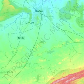
Name: Katni topographic map, elevation, terrain.
Location: Katni, Katni District, Madhya Pradesh, 483442, India (23.65812 80.29865 23.83681 80.55555)
Average elevation: 1,368 ft
Minimum elevation: 1,207 ft
Maximum elevation: 2,037 ft
Make a donation
Gear up for your next adventure:
As an Amazon Associate, this site earns from qualifying purchases at no extra cost to you.
Other topographic maps
Click on a map to view its topography, its elevation and its terrain.
Amarkantak
India > Madhya Pradesh > Pushparajgarh Tehsil
Amarkantak is located in Madhya Pradesh in India at 22°40′N 81°45′E / 22.67°N 81.75°E / 22.67; 81.75. It has an average elevation of 1,048 m (3,438 ft). Roads running through Rewa, Shahdol, Anuppur, Jabalpur, Katni, Bilaspur and Gaurella connect it. The nearest railway stations are Pendra Road…
Average elevation: 2,900 ft
Ujjain
India > Madhya Pradesh > Ujjain NagarTahsil
Ujjain is located in the west-central part of India, and is north of the upper limit of the Vindhya mountain ranges. Located on the Malwa plateau, it is higher than the north Indian plains and the land rises towards the Vindhya Range to the south. Ujjain's coordinates are 23°10′N 75°46′E /…
Average elevation: 1,644 ft
Make a donation
Gear up for your next adventure:
As an Amazon Associate, this site earns from qualifying purchases at no extra cost to you.
Make a donation
Gear up for your next adventure:
As an Amazon Associate, this site earns from qualifying purchases at no extra cost to you.
Make a donation
Gear up for your next adventure:
As an Amazon Associate, this site earns from qualifying purchases at no extra cost to you.
Make a donation
Gear up for your next adventure:
As an Amazon Associate, this site earns from qualifying purchases at no extra cost to you.
Make a donation
Gear up for your next adventure:
As an Amazon Associate, this site earns from qualifying purchases at no extra cost to you.
Lahar
India > Madhya Pradesh > Lahar Tahsil
Lahar is located at 26°07′N 78°34′E / 26.11°N 78.56°E / 26.11; 78.56. It has an average elevation of 275 metres (902 feet). Sports facilities in Lahar including a cricket stadium named after Indira Gandhi.
Average elevation: 509 ft
Make a donation
Gear up for your next adventure:
As an Amazon Associate, this site earns from qualifying purchases at no extra cost to you.
Pench (Indira Priyadarsini) National Park/Tiger Reserve
India > Madhya Pradesh > Bichhua Tahsil
Average elevation: 1,591 ft
Narsinghpur
India > Madhya Pradesh > Narsimhapur Tahsil > Narsinghpur
Narsinghpur is located at 22°57′N 79°12′E / 22.95°N 79.2°E / 22.95; 79.2. It has an average elevation of 347 metres (1,138 ft).
Average elevation: 1,168 ft
Make a donation
Gear up for your next adventure:
As an Amazon Associate, this site earns from qualifying purchases at no extra cost to you.
Make a donation
Gear up for your next adventure:
As an Amazon Associate, this site earns from qualifying purchases at no extra cost to you.
Hatpipalya
India > Madhya Pradesh > Hatpiplya Tahsil
Hatpipliya lies on the Malwa Plateau. Due of its high elevation and inland location, even during the hottest months of the year, the nights are relatively cool, which is known as Shab-e-Malwa. Three distinct seasons are observed: summer, monsoon and winter. Hatpipliya gets moderate rainfall of 960 millimetres…
Average elevation: 1,716 ft
Make a donation
Gear up for your next adventure:
As an Amazon Associate, this site earns from qualifying purchases at no extra cost to you.
Make a donation
Gear up for your next adventure:
As an Amazon Associate, this site earns from qualifying purchases at no extra cost to you.