
Macon County topographic map
Interactive map
Click on the map to display elevation.
Macon County
Macon County is primarily flat, as is most of the state and all of the surrounding counties, the result of geological activity during the Pleistocene epoch. During the Illinoian Stage of the Pleistocene, the Laurentide Ice Sheet covered about 85 percent of Illinois, including the Macon County area. The subsequent thaw of the region and retreat of the ice sheet left central Illinois with its present characteristic flat topography.
About this map
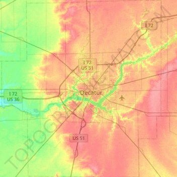
Name: Macon County topographic map, elevation, terrain.
Location: Macon County, Illinois, United States (39.65268 -89.21788 40.05534 -88.74504)
Average elevation: 666 ft
Minimum elevation: 564 ft
Maximum elevation: 751 ft
Illinois trails, hiking, mountain biking, running and outdoor activities
Other topographic maps
Click on a map to view its topography, its elevation and its terrain.
Sand Lake
United States > Illinois > Lake County > Lindenhurst > Venetian Village
Average elevation: 787 ft
West Frankfort
United States > Illinois > Franklin County
The area of West Frankfort formerly known as Frankfort is still sometimes referred to locally as Frankfort Heights or, more commonly, simply as "The Heights", due to its higher elevation relative to the rest of the city. A post office was maintained in Frankfort Heights until its destruction by fire in 2004,…
Average elevation: 400 ft