
Montgomery County topographic map
Click on the map to display elevation.
Montgomery County
Montgomery County features a predominantly flat terrain, with average elevations ranging from about 100 to 350 feet above sea level. The landscape is gently rolling, particularly towards the northern areas, and is interspersed with several lakes, such as the expansive Lake Conroe. This large reservoir, formed by the damming of the West Fork of the San Jacinto River, is a key topographical feature of the county. The area is dotted with wetlands and minor ridges, contributing to a mix of forested regions and open plains. While most of the county remains below 300 feet in elevation, it exhibits subtle variations in terrain, particularly near the lake and in parts of the Sam Houston National Forest.
About this map
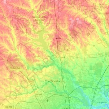
Name: Montgomery County topographic map, elevation, terrain.
Location: Montgomery County, Texas, United States (30.02605 -95.83016 30.63042 -95.09665)
Average elevation: 226 ft
Minimum elevation: 43 ft
Maximum elevation: 482 ft
Texas trails, hiking, mountain biking, running and outdoor activities
Other topographic maps
Click on a map to view its topography, its elevation and its terrain.
Padre Island National Seashore
United States > Texas > Kenedy County > Corpus Christi
Average elevation: 16 ft
Flint
United States > Texas > Smith County
Flint is an unincorporated community in southeastern Smith County, Texas, United States. It lies along FM 2493, south of the city of Tyler, the county seat of Smith County. Its elevation is 522 feet (159 m). Although Flint is unincorporated, it has a post office, with the ZIP code of 75762.
Average elevation: 479 ft
Choke Canyon State Park - Calliham Unit
United States > Texas > McMullen County > Calliham
Average elevation: 220 ft
Mineral Wells Fossil Park
United States > Texas > Palo Pinto County > Mineral Wells
Average elevation: 928 ft
Rio Vista Addition Colonia
United States > Texas > El Paso County > Socorro
Average elevation: 3,661 ft
Georgetown
United States > Texas > Georgetown
The city is located on the northeastern edge of Texas Hill Country. Portions of Georgetown are located on either side of the Balcones Escarpment, a fault line in which the areas roughly east of IH-35 are flat and characterized by having black, fertile soils of the Blackland Prairie, and the west side of the…
Average elevation: 719 ft
Highlands
United States > Texas > Harris County
The community was named Highlands because the east bank of the San Jacinto River, where Highlands is located, has a higher elevation than the west bank of the river. By 1908, Highlands became a station on the Beaumont, Sour Lake and Western Railway. A post office opened in 1929. Highlands incorporated in 1930,…
Average elevation: 26 ft
Bergheim
United States > Texas > Kendall County
Bergheim is an unincorporated community in eastern Kendall County, Texas, United States known for its German-Texan culture and heritage. It lies along State Highway 46 east of the city of Boerne, the county seat of Kendall County. Its elevation is 1,437 feet (438 m). Although Bergheim is unincorporated, it has…
Average elevation: 1,375 ft
South Palm Gardens Estates Number 1 Colonia
United States > Texas > Hidalgo County > Weslaco
Average elevation: 75 ft
Inks Lake State Park
United States > Texas > Burnet County > Burnet
Conservation Pool Elevation usually stays around 888.22 ft. msl; however, this lake does fluctuate about 1 foot annually. Inks lake water clarity can be seen as clear to slightly stained mostly throughout the year. It tends to have higher turbidity during the rainy season due to excessive amounts of runoff.
Average elevation: 965 ft
Brazos Bend State Park
United States > Texas > Fort Bend County > Alvin
Brazos Bend State Park occupies land bordering the Brazos River and includes within its boundaries low-lying areas left over from the River's previous meanderings. Pre-Columbian inhabitants included a series of Native American groups, most notably the Karankawa. The land passed through a variety of landowners'…
Average elevation: 56 ft
Anthony
United States > Texas > El Paso County
Anthony has a desert climate, with a high degree of diurnal temperature variation due to the relatively high elevation and aridity.
Average elevation: 3,848 ft