
Make a donation
Gear up for your next adventure:
As an Amazon Associate, this site earns from qualifying purchases at no extra cost to you.
Akkar Governorate topographic map
Click on the map to display elevation.
Make a donation
Gear up for your next adventure:
As an Amazon Associate, this site earns from qualifying purchases at no extra cost to you.
About this map
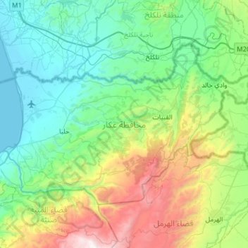
Name: Akkar Governorate topographic map, elevation, terrain.
Location: Akkar Governorate, Lebanon (34.41919 35.95440 34.69214 36.46493)
Average elevation: 2,087 ft
Minimum elevation: 0 ft
Maximum elevation: 8,976 ft
Make a donation
Gear up for your next adventure:
As an Amazon Associate, this site earns from qualifying purchases at no extra cost to you.
Other topographic maps
Click on a map to view its topography, its elevation and its terrain.
Tripoli
The urban form of Mamluk Tripoli was dictated mainly by climate, site configuration, defense, and urban aesthetics. The layout of major thoroughfares was set according to prevailing winds and topography. The city had no fortifications, but heavy building construction characterized by compact urban forms,…
Average elevation: 692 ft
Aramoun
Lebanon > Mount Lebanon Governorate
Aramoun (Arabic: عرمون), often referred to as Dawhet Aramoun (Arabic: دوحة عرمون), is a village in the Aley District of Mount Lebanon, Lebanon, lying to the east of Khalde and 22 kilometres away from Beirut. Aramoun's altitude ranges between 250 meters to 600 meters further east. The village has…
Average elevation: 1,568 ft
Kfardebian
Lebanon > Keserwan-Jbeil Governorate
Kfardebian (Arabic: كفر دبيان; also spelled Kfar Dibiane and also known as Moucha'a Keserwan) is a municipality in the Keserwan District of the Keserwan-Jbeil Governorate in Lebanon. It is located 45 kilometers north of Beirut. Its average elevation is 1,220 meters above sea level and its total land…
Average elevation: 5,768 ft
Make a donation
Gear up for your next adventure:
As an Amazon Associate, this site earns from qualifying purchases at no extra cost to you.
Deir Al Qamar
Lebanon > Mount Lebanon Governorate
Deir al-Qamar (Arabic: دَيْر الْقَمَر, romanized: Dayr al-qamar, lit. 'Monastery of the moon') is a city south-east of Beirut in south-central Lebanon. It is located five kilometres outside of Beiteddine in the Chouf District of the Mount Lebanon Governorate at 800 m of average altitude.
Average elevation: 2,474 ft
Ehden
Ehden is located in the central northern side of Mount Lebanon, with a 1500-metre (at Midan square) elevation from sea level. It is 120 kilometres (75 mi) from Beirut, 30 kilometres (19 mi) from Tripoli and 25 kilometres (16 mi) from Zgharta. Ehden used to be the sole residence for Zghartians prior to the…
Average elevation: 4,429 ft
Make a donation
Gear up for your next adventure:
As an Amazon Associate, this site earns from qualifying purchases at no extra cost to you.
Tannourine
Tannourine is the plural of the Syriac word tannour, which indicates an old stone oven. Tannourine's name may in fact stem from the local topography, which resembles the convex form of an oven called tannour, with the dual suffix ine as a reference to the two distinct areas of Tannourine Al-Tahta (literally…
Average elevation: 5,253 ft
Make a donation
Gear up for your next adventure:
As an Amazon Associate, this site earns from qualifying purchases at no extra cost to you.
Make a donation
Gear up for your next adventure:
As an Amazon Associate, this site earns from qualifying purchases at no extra cost to you.
Ballouneh
Lebanon > Keserwan-Jbeil Governorate
Ballouneh (Arabic: بلونة) is a town and municipality in the Keserwan District of the Keserwan-Jbeil Governorate of Lebanon. It is located 18 kilometers north of Beirut. It has an approximate area of 3.93 square kilometers and an average elevation of 650 meters above sea level. Ballouneh's inhabitants are…
Average elevation: 2,133 ft
Antelias
Lebanon > Mount Lebanon Governorate
The municipality of Antelias - Naqqach is located in the Kaza of Metn in Mount Lebanon, one of the eight mohafazats (governorates) of Lebanon. Antelias - Naqqach is 8 kilometers (4.9712 mi) from Beyrouth (Beirut), the capital of Lebanon. Its elevation is 10 meters (32.81 ft; 10.936 yd) above sea level.…
Average elevation: 646 ft
Make a donation
Gear up for your next adventure:
As an Amazon Associate, this site earns from qualifying purchases at no extra cost to you.
Make a donation
Gear up for your next adventure:
As an Amazon Associate, this site earns from qualifying purchases at no extra cost to you.
Make a donation
Gear up for your next adventure:
As an Amazon Associate, this site earns from qualifying purchases at no extra cost to you.
Nabay
Lebanon > Mount Lebanon Governorate
Nabay (Arabic: نابيه, from the Aramaic: נביא ; ܢܒܺܝܶ̈ܐ) is a village located in the Matn District (kada), Mount Lebanon Governorate (Mohafazat). Nabay is located 16 kilometers (9.9424 mi) away from the capital Beirut. Its elevation is 500 meters (1640.5 ft - 546.8 yd) above sea level. Nabay…
Average elevation: 1,453 ft
Make a donation
Gear up for your next adventure:
As an Amazon Associate, this site earns from qualifying purchases at no extra cost to you.
Make a donation
Gear up for your next adventure:
As an Amazon Associate, this site earns from qualifying purchases at no extra cost to you.
Make a donation
Gear up for your next adventure:
As an Amazon Associate, this site earns from qualifying purchases at no extra cost to you.
Temnin el-Foka
Lebanon > Baalbek-Hermel Governorate
Temnin el-Foka (Arabic: تمنين الفوقا) is a village located approximately 28 kilometers southwest of Baalbek in the Baalbek District, in the Beqaa valley of Lebanon, at an altitude of 1100 meters above sea level. The village is famous for its Roman nymphaeum which is close to the spring of Ain el-Jobb.
Average elevation: 3,789 ft
Kfar Mishki
Kfarmishki, also spelled Kfar Mishki or Kfar Mechki (Arabic: كفرمشكي), is a small mountain authority in the Rashaya District of the Beqaa Governate in Lebanon. This village is located approximately 92 km southeast of Beirut and lies at an altitude of 950–1350 m above sea level on the western slope of…
Average elevation: 3,422 ft
Make a donation
Gear up for your next adventure:
As an Amazon Associate, this site earns from qualifying purchases at no extra cost to you.
Jezzine
Jezzine (Arabic: جزين Jizzīn) is a town in Lebanon, located 22 km (14 mi) from Sidon and 40 km (25 mi) south of Beirut. It is the capital of Jezzine District. Surrounded by mountain peaks, pine forests (like the Bkassine Pine Forest), and at an average altitude of 950 m (3,117 ft), it is the main summer…
Average elevation: 3,517 ft
Make a donation
Gear up for your next adventure:
As an Amazon Associate, this site earns from qualifying purchases at no extra cost to you.
Beirut
The average annual rainfall is 825 millimetres (32.5 in), with the large majority of it falling from October to April. Much of the autumn and spring rain falls in heavy downpours on a limited number of days, but in winter it is spread more evenly over many days. Summer receives very little rainfall, if any.…
Average elevation: 476 ft
Make a donation
Gear up for your next adventure:
As an Amazon Associate, this site earns from qualifying purchases at no extra cost to you.
Make a donation
Gear up for your next adventure:
As an Amazon Associate, this site earns from qualifying purchases at no extra cost to you.
Make a donation
Gear up for your next adventure:
As an Amazon Associate, this site earns from qualifying purchases at no extra cost to you.
Make a donation
Gear up for your next adventure:
As an Amazon Associate, this site earns from qualifying purchases at no extra cost to you.
Make a donation
Gear up for your next adventure:
As an Amazon Associate, this site earns from qualifying purchases at no extra cost to you.