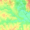
Navarro County topographic map
Click on the map to display elevation.
Navarro County
Navarro County occupies a gently varied part of north-central Texas where broad Blackland Prairie terrain gives way eastward to lower, more dissected creek and reservoir landscapes. The county is described as mostly level to rolling blacklands, with open prairie dominant and woodland areas of oak, hickory, and pine in places, while the Trinity River forms its northeastern boundary. Elevations generally descend from the higher western and southwestern margins toward the lower eastern drainage corridors, with the provided elevation data suggesting a local range from about 250 to 600 ft (76 to 183 m). Around Corsicana and the central county, relief is modest and agricultural plains are cut by shallow valleys, while Richland Creek, Chambers Creek, Navarro Mills Lake, and the large Richland-Chambers Reservoir create broader low-lying basins and gently embayed shorelines; the reservoir’s conservation pool is listed at 315 ft (96 m) above mean sea level. Overall, Navarro County’s topography is not mountainous but softly undulating, with a prairie-and-drainage character shaped by clay-rich uplands, gradual slopes, and the eastward organization of creeks and river bottoms.
About this map
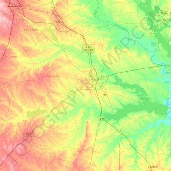
Name: Navarro County topographic map, elevation, terrain.
Location: Navarro County, Texas, United States (31.79629 -96.89618 32.32922 -96.05079)
Average elevation: 430 ft
Minimum elevation: 240 ft
Maximum elevation: 748 ft
Texas trails, hiking, mountain biking, running and outdoor activities
Other topographic maps
Click on a map to view its topography, its elevation and its terrain.
Austin
United States > Texas > Travis County > Austin
The elevation of Austin varies from 425 feet (130 m) to approximately 1,000 feet (305 m) above sea level. Due to the fact it straddles the Balcones Fault, much of the eastern part of the city is flat, with heavy clay and loam soils, whereas the western part and western suburbs consist of rolling hills on the…
Average elevation: 666 ft
San Luis Pass
United States > Texas > Galveston County > Galveston
Tides cause daily variations in topography, and occasionally, storms more drastically change the topography of the pass.
Average elevation: 0 ft

Lower Rio Grande Valley National Wildlife Refuge
United States > Texas > Starr County > Rio Grande City
Average elevation: 164 ft



Belton
United States > Texas > Bell County > Belton > Belton
Belton is located 60 miles (97 km) north of Austin, 137 miles (220 km) south of Dallas, and 184 miles (296 km) west of Houston. It is near the center of Bell County at 31°3′32″N 97°27′48″W / 31.05889°N 97.46333°W / 31.05889; -97.46333 (31.058904, -97.463382). It is at the point where the…
Average elevation: 577 ft
Guadalupe Peak
United States > Texas > Culberson County
Guadalupe Peak, also known as Signal Peak, is the highest natural point in Texas, with an elevation of 8,751 feet (2,667 m) above sea level. It is located in Guadalupe Mountains National Park, and is part of the Guadalupe Mountains range in southeastern New Mexico and West Texas. The mountain is about 90 miles…
Average elevation: 7,054 ft







Enchanted Rock
United States > Texas > Llano County
Enchanted Rock is a pink granite mountain located in the Llano Uplift about 17 miles (27 km) north of Fredericksburg, Texas and 24 miles (39 km) south of Llano, Texas, United States. Enchanted Rock State Natural Area, which includes Enchanted Rock and surrounding land, spans the border between Gillespie and…
Average elevation: 1,486 ft
Padre Island National Seashore
United States > Texas > Kenedy County > Corpus Christi
Average elevation: 16 ft