
Travis County topographic map
Click on the map to display elevation.
Travis County
Travis County features a varied and dynamic topography characterized by rolling hills, lush valleys, and significant water features. The terrain rises gently from the flatlands in the east to the more rugged and elevated areas in the west, reaching elevations of up to about 1,400 feet above sea level. The county is bisected by the scenic Colorado River, which flows through the area, creating picturesque landscapes and providing recreational opportunities. Notable features include the limestone escarpments and the scenic vistas along the Balcones Fault, which delineates the eastern edge of the Texas Hill Country. This diverse topography supports a mix of ecosystems, including hardwood forests, grassy plains, and areas of dense brush, contributing to the region's natural beauty and outdoor recreational activities.
About this map
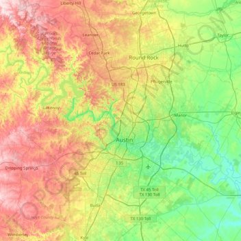
Name: Travis County topographic map, elevation, terrain.
Location: Travis County, Texas, United States (30.02333 -98.17314 30.62803 -97.36958)
Average elevation: 758 ft
Minimum elevation: 335 ft
Maximum elevation: 1,486 ft
Texas trails, hiking, mountain biking, running and outdoor activities
Other topographic maps
Click on a map to view its topography, its elevation and its terrain.
Enchanted Rock
United States > Texas > Llano County
Enchanted Rock is a pink granite mountain located in the Llano Uplift about 17 miles (27 km) north of Fredericksburg, Texas and 24 miles (39 km) south of Llano, Texas, United States. Enchanted Rock State Natural Area, which includes Enchanted Rock and surrounding land, spans the border between Gillespie and…
Average elevation: 1,486 ft
Padre Island National Seashore
United States > Texas > Kenedy County > Corpus Christi
Average elevation: 16 ft
Choke Canyon State Park - Calliham Unit
United States > Texas > McMullen County > Calliham
Average elevation: 220 ft
Mineral Wells Fossil Park
United States > Texas > Palo Pinto County > Mineral Wells
Average elevation: 928 ft