Travis County topographic map
Interactive map
Click on the map to display elevation.
About this map
![Travis County topographic map, elevation, terrain](/pub/maps/relation/fx4s/ckttj/thumbnail.jpg)
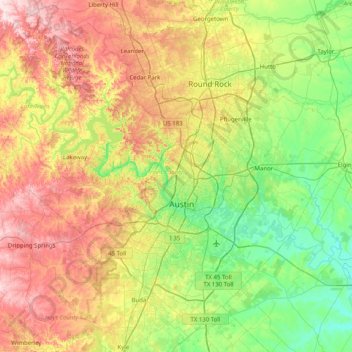
Name: Travis County topographic map, elevation, terrain.
Location: Travis County, Texas, United States (30.02333 -98.17314 30.62803 -97.36958)
Average elevation: 758 ft
Minimum elevation: 335 ft
Maximum elevation: 1,486 ft
Travis County straddles the Balcones Fault, the boundary between the Edwards Plateau to the west and the Texas Coastal Plain to the east. The western part of the county is characterized by the karst topography of the Texas Hill Country, while the eastern part exhibits the fertile plains and farmlands of the Blackland Prairie. The Colorado River meanders through the county from west to east, forming a series of man-made lakes (Lake Travis, Lake Austin, and Lady Bird Lake).
Other topographic maps
Click on a map to view its topography, its elevation and its terrain.
![Houston topographic map, elevation, terrain](/pub/maps/relation/3km2/ln7ks8/icon.jpg)
Houston
United States > Texas > Harris County
Houston, Harris County, Texas, United States
Average elevation: 82 ft
![Austin topographic map, elevation, terrain](/pub/maps/relation/ncm2/4gjdn/icon.jpg)
Austin
United States > Texas > Travis County
Austin, Travis County, Texas, United States
Average elevation: 709 ft
![Dallas topographic map, elevation, terrain](/pub/maps/relation/f3kl/6dx4nh/icon.jpg)
Dallas
United States > Texas > Dallas County
Dallas, Dallas County, Texas, United States
Average elevation: 525 ft
![Fort Worth topographic map, elevation, terrain](/pub/maps/relation/k94s/8zhtp/icon.jpg)
Fort Worth
United States > Texas > Tarrant County
Fort Worth, Tarrant County, Texas, United States
Average elevation: 696 ft
![San Antonio topographic map, elevation, terrain](/pub/maps/relation/xgt6/ph8tj/icon.jpg)
San Antonio
United States > Texas > Bexar County
San Antonio, Bexar County, Texas, United States
Average elevation: 810 ft
![Kerrville topographic map, elevation, terrain](/pub/maps/relation/klz4/xhbt18/icon.jpg)
Kerrville
United States > Texas > Kerr County
Kerrville, Kerr County, Texas, United States
Average elevation: 1,788 ft
![El Paso topographic map, elevation, terrain](/pub/maps/relation/m5mt/wh257/icon.jpg)
El Paso
United States > Texas > El Paso County
El Paso, El Paso County, Texas, United States
Average elevation: 4,058 ft
![Amarillo topographic map, elevation, terrain](/pub/maps/relation/hmm2/4jpdn/icon.jpg)
Amarillo
United States > Texas > Potter County
Amarillo, Potter County, Texas, United States
Average elevation: 3,599 ft
![Granbury topographic map, elevation, terrain](/pub/maps/relation/223q/mbvgt/icon.jpg)
Granbury
United States > Texas > Hood County
Granbury, Hood County, Texas, 76048, United States
Average elevation: 794 ft
![Montgomery County topographic map, elevation, terrain](/pub/maps/relation/kgt/69ljtf/icon.jpg)
Montgomery County
Montgomery County, Texas, United States
Average elevation: 226 ft
![Corpus Christi topographic map, elevation, terrain](/pub/maps/relation/6nzs/c2k5k/icon.jpg)
Corpus Christi
United States > Texas > Nueces County
Corpus Christi, Nueces County, Texas, United States
Average elevation: 26 ft
![Kingwood topographic map, elevation, terrain](/pub/maps/node/pj3q/lk2vr31h/icon.jpg)
Kingwood
United States > Texas > Harris County > Houston
Kingwood, Houston, Harris County, Texas, 77345, United States
Average elevation: 72 ft
![McKinney topographic map, elevation, terrain](/pub/maps/relation/sntp/gg4pkl/icon.jpg)
McKinney
United States > Texas > Collin County
McKinney, Collin County, Texas, United States
Average elevation: 633 ft
![Alpine topographic map, elevation, terrain](/pub/maps/relation/4mdn/2dj3q/icon.jpg)
Alpine
United States > Texas > Brewster County
Alpine, Brewster County, Texas, United States
Average elevation: 4,505 ft
![Williamson County topographic map, elevation, terrain](/pub/maps/relation/m8m2/sz9k18/icon.jpg)
Williamson County
Williamson County, Texas, United States
Average elevation: 728 ft
![Katy topographic map, elevation, terrain](/pub/maps/relation/prcz/ffhhgt/icon.jpg)
Katy
United States > Texas > Fort Bend County
Katy, Fort Bend County, Texas, United States
Average elevation: 144 ft
![Spring topographic map, elevation, terrain](/pub/maps/node/6ptp/l7hlptp/icon.jpg)
Spring
United States > Texas > Harris County
Spring, Harris County, Texas, 77373, United States
Average elevation: 115 ft
![Laredo topographic map, elevation, terrain](/pub/maps/relation/6mkl/t9xm2/icon.jpg)
Laredo
United States > Texas > Webb County
Laredo, Webb County, Texas, United States
Average elevation: 525 ft
![South Padre Island topographic map, elevation, terrain](/pub/maps/relation/7h9m/66mtnh/icon.jpg)
South Padre Island
United States > Texas > Cameron County
South Padre Island, Cameron County, Texas, 78597, United States
Average elevation: 0 ft
![San Angelo topographic map, elevation, terrain](/pub/maps/relation/xsf3/773mz4/icon.jpg)
San Angelo
United States > Texas > Tom Green County
San Angelo, Tom Green County, Texas, United States
Average elevation: 1,890 ft
![Cypress topographic map, elevation, terrain](/pub/maps/node/7rnh/h3tg7rr/icon.jpg)
Cypress
United States > Texas > Harris County
Cypress, Harris County, Texas, 77433, United States
Average elevation: 151 ft
![Lubbock topographic map, elevation, terrain](/pub/maps/relation/br57/l2d9m/icon.jpg)
Lubbock
United States > Texas > Lubbock County
Lubbock, Lubbock County, Texas, United States
Average elevation: 3,241 ft
![Kanawha topographic map, elevation, terrain](/pub/maps/node/nr3q/s6pv1mt/icon.jpg)
Kanawha
United States > Texas > Red River County
Kanawha, Red River County, Texas, United States
Average elevation: 443 ft
![Denton topographic map, elevation, terrain](/pub/maps/relation/6ks8/7tdkl/icon.jpg)
Denton
United States > Texas > Denton County
Denton, Denton County, Texas, United States
Average elevation: 640 ft
![Galveston Island topographic map, elevation, terrain](/pub/maps/node/mjdn/rbg4w4s/icon.jpg)
Galveston Island
United States > Texas > Galveston County > Galveston
Galveston Island, Galveston, Galveston County, Texas, 77554, United States
Average elevation: 7 ft
![Boerne topographic map, elevation, terrain](/pub/maps/relation/9dt6/fcv18/icon.jpg)
Boerne
United States > Texas > Kendall County
Boerne, Kendall County, Texas, United States
Average elevation: 1,526 ft
![Longview topographic map, elevation, terrain](/pub/maps/relation/m1tp/fc2s8/icon.jpg)
Longview
United States > Texas > Gregg County
Longview, Gregg County, Texas, United States
Average elevation: 344 ft
![Sugar Land topographic map, elevation, terrain](/pub/maps/relation/mnm2/66m81h/icon.jpg)
Sugar Land
United States > Texas > Fort Bend County
Sugar Land, Fort Bend County, Texas, United States
Average elevation: 79 ft
![Pearland topographic map, elevation, terrain](/pub/maps/relation/hl51/6v74s/icon.jpg)
Pearland
United States > Texas > Brazoria County
Pearland, Brazoria County, Texas, 77581, United States
Average elevation: 46 ft
![Round Rock topographic map, elevation, terrain](/pub/maps/relation/8ldn/2kr3q/icon.jpg)
Round Rock
United States > Texas > Williamson County
Round Rock, Williamson County, Texas, United States
Average elevation: 794 ft
![Waco topographic map, elevation, terrain](/pub/maps/relation/54nx/8j7gp/icon.jpg)
Waco
United States > Texas > McLennan County
Waco, McLennan County, Texas, United States
Average elevation: 482 ft
![Killeen topographic map, elevation, terrain](/pub/maps/relation/bf5k/r6dtj/icon.jpg)
Killeen
United States > Texas > Bell County
Killeen, Bell County, Texas, United States
Average elevation: 873 ft
![Detroit topographic map, elevation, terrain](/pub/maps/relation/87gt/fv13m2/icon.jpg)
Detroit
United States > Texas > Red River County
Detroit, Red River County, Texas, 75436, United States
Average elevation: 492 ft
![Horseshoe Bay topographic map, elevation, terrain](/pub/maps/node/68kl/vhczptj/icon.jpg)
Horseshoe Bay
United States > Texas > Llano County > Horseshoe Bay > Horseshoe Bay
Horseshoe Bay, Llano County, Texas, 78657, United States
Average elevation: 938 ft
![Georgetown topographic map, elevation, terrain](/pub/maps/relation/p4m2/2363cz/icon.jpg)
Georgetown
United States > Texas > Williamson County
Georgetown, Williamson County, Texas, United States
Average elevation: 810 ft
![Livingston topographic map, elevation, terrain](/pub/maps/relation/mfmt/kk1s9m/icon.jpg)
Livingston
United States > Texas > Polk County
Livingston, Polk County, Texas, United States
Average elevation: 207 ft
![Weatherford topographic map, elevation, terrain](/pub/maps/relation/d718/3z41h/icon.jpg)
Weatherford
United States > Texas > Parker County
Weatherford, Parker County, Texas, 76086, United States
Average elevation: 1,070 ft
![Port Aransas topographic map, elevation, terrain](/pub/maps/relation/l1gt/ffhvmt/icon.jpg)
Port Aransas
United States > Texas > Nueces County
Port Aransas, Nueces County, Texas, 78373, United States
Average elevation: 3 ft
![Conroe topographic map, elevation, terrain](/pub/maps/relation/743l/177cz/icon.jpg)
Conroe
United States > Texas > Montgomery County
Conroe, Montgomery County, Texas, United States
Average elevation: 203 ft
![Rockport topographic map, elevation, terrain](/pub/maps/relation/9mf3/778pz4/icon.jpg)
Rockport
United States > Texas > Aransas County
Rockport, Aransas County, Texas, 78382, United States
Average elevation: 10 ft