
Henry County topographic map
Interactive map
Click on the map to display elevation.
Henry County
According to the US Census Bureau, the county has a total area of 826 square miles (2,140 km2), of which 823 square miles (2,130 km2) is land and 2.7 square miles (7.0 km2) (0.3%) is water. It is the 29th largest of Illinois' 102 counties. The area is fairly flat, with elevations ranging from 650 feet above sea level in the northwest to 850 in the southeast. About 456,596 acres (1,847.78 km2) or 86.7% of the county's land area, is used for agriculture.
About this map
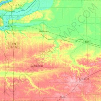
Name: Henry County topographic map, elevation, terrain.
Location: Henry County, Illinois, United States (41.14940 -90.43770 41.58625 -89.85674)
Average elevation: 702 ft
Minimum elevation: 558 ft
Maximum elevation: 883 ft
Illinois trails, hiking, mountain biking, running and outdoor activities
Other topographic maps
Click on a map to view its topography, its elevation and its terrain.
Sand Lake
United States > Illinois > Lake County > Lindenhurst > Venetian Village
Average elevation: 787 ft
West Frankfort
United States > Illinois > Franklin County
The area of West Frankfort formerly known as Frankfort is still sometimes referred to locally as Frankfort Heights or, more commonly, simply as "The Heights", due to its higher elevation relative to the rest of the city. A post office was maintained in Frankfort Heights until its destruction by fire in 2004,…
Average elevation: 400 ft