
Terrell County topographic map
Interactive map
Click on the map to display elevation.
About this map
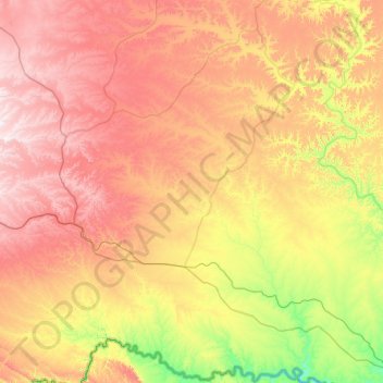
Name: Terrell County topographic map, elevation, terrain.
Location: Terrell County, Texas, United States (29.77909 -102.56698 30.65836 -101.64626)
Average elevation: 2,425 ft
Minimum elevation: 1,181 ft
Maximum elevation: 3,996 ft
Texas trails, hiking, mountain biking, running and outdoor activities
Other topographic maps
Click on a map to view its topography, its elevation and its terrain.
Medina River Natural Area
United States > Texas > Bexar County > San Antonio
Average elevation: 551 ft
Georgetown
United States > Texas > Georgetown
The city is located on the northeastern edge of Texas Hill Country. Portions of Georgetown are located on either side of the Balcones Escarpment, a fault line in which the areas roughly east of IH-35 are flat and characterized by having black, fertile soils of the Blackland Prairie, and the west side of the…
Average elevation: 719 ft
Bacliff
United States > Texas > Galveston County
After Hurricane Ike hit Texas in September 2008, Galveston County officials offered a debris removal program to residents in unincorporated areas, including Bacliff. Flooding from hurricane Ike was minimized due in part to Bacliff's relatively high elevation of 16 feet.
Average elevation: 13 ft
Choke Canyon State Park - Calliham Unit
United States > Texas > McMullen County > Calliham
Average elevation: 220 ft
Emory Peak
United States > Texas > Brewster County
The peak can be reached by a moderate hike on a well-marked path across steep rocky terrain with an elevation gain of approximately 2,500 feet (760 m). The Emory Peak Trail is about 1.5 miles (2.4 km) long. The trail is reached by climbing the Pinnacles Trail 3.5 miles (5.6 km) from the Chisos Basin trailhead.…
Average elevation: 6,762 ft
Farnsworth
United States > Texas > Ochiltree County
Farnsworth is a census designated place in western Ochiltree County, Texas, United States. It lies at the intersection of State Highway 15 with FM376, southwest of the city of Perryton, the county seat of Ochiltree County. Its elevation is 2,995 feet (913 m). Although Farnsworth is unincorporated, it has a…
Average elevation: 2,995 ft
Lower Rio Grande Valley National Wildlife Refuge
United States > Texas > Starr County > Rio Grande City
Average elevation: 164 ft
San Luis Pass
United States > Texas > Galveston County > Galveston
Tides cause daily variations in topography, and occasionally, storms more drastically change the topography of the pass.
Average elevation: 0 ft
Altamira West Number 2 Colonia
United States > Texas > Hidalgo County > Edinburg
Average elevation: 105 ft
San Juan South Estates Colonia
United States > Texas > Hidalgo County > San Juan
Average elevation: 112 ft
Soil Conservation Service Site 12 Dam
United States > Texas > Williamson County > Type
Average elevation: 568 ft