
Camden County topographic map
Interactive map
Click on the map to display elevation.
About this map
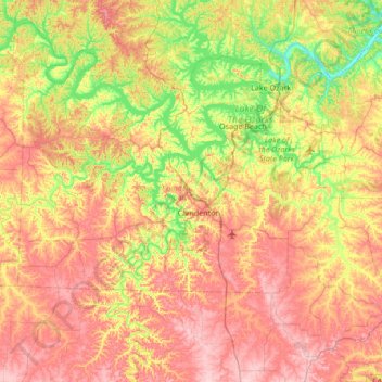
Name: Camden County topographic map, elevation, terrain.
Location: Camden County, Missouri, United States (37.79913 -93.08280 38.27069 -92.40626)
Average elevation: 883 ft
Minimum elevation: 545 ft
Maximum elevation: 1,250 ft
Missouri trails, hiking, mountain biking, running and outdoor activities
Other topographic maps
Click on a map to view its topography, its elevation and its terrain.
Creve Coeur Lake
United States > Missouri > Saint Louis County > Maryland Heights
Average elevation: 492 ft