
Hickory County topographic map
Interactive map
Click on the map to display elevation.
About this map
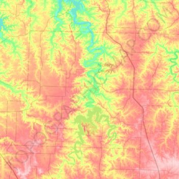
Name: Hickory County topographic map, elevation, terrain.
Location: Hickory County, Missouri, United States (37.80581 -93.57622 38.07332 -93.06426)
Average elevation: 951 ft
Minimum elevation: 686 ft
Maximum elevation: 1,214 ft
Missouri trails, hiking, mountain biking, running and outdoor activities
Other topographic maps
Click on a map to view its topography, its elevation and its terrain.
Creve Coeur Lake
United States > Missouri > Saint Louis County > Maryland Heights
Average elevation: 492 ft