
Picnic Grove topographic map
Interactive map
Click on the map to display elevation.
About this map
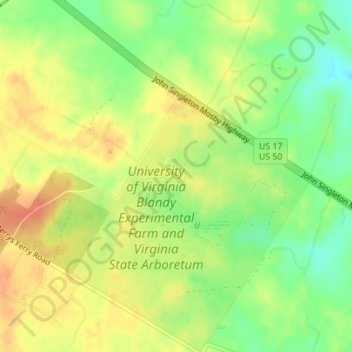
Name: Picnic Grove topographic map, elevation, terrain.
Location: Picnic Grove, Clarke County, Virginia, United States (39.06355 -78.06402 39.06418 -78.06309)
Average elevation: 587 ft
Minimum elevation: 509 ft
Maximum elevation: 650 ft
Virginia trails, hiking, mountain biking, running and outdoor activities
Other topographic maps
Click on a map to view its topography, its elevation and its terrain.
Virginia Beach
United States > Virginia > Virginia Beach
Virginia Beach, Virginia, located in the coastal region of the United States, features a predominantly flat terrain characterized by its proximity to the Atlantic Ocean. The elevation is remarkably low, averaging about 10 feet (3 meters) above sea level, which contributes to the area's susceptibility to…
Average elevation: 7 ft
Wattsville
United States > Virginia > Accomack County
It lies at an elevation of 3 feet.
Average elevation: 36 ft
Smith Mountain Lake
United States > Virginia > Franklin County > North Shore
Average elevation: 902 ft
Carroll County
The first European settlers arrived in the region in the mid 18th century. These were primarily Scotch-Irish pioneers, who were used to high mountain altitudes. However, early settlement was slow, mostly due to the poor agricultural soil of the area. As a result, lead mining was one of the first economic…
Average elevation: 2,326 ft
Thousand Trails Chesapeake Bay RV Resort
United States > Virginia > Gloucester County
Average elevation: 33 ft
C.F. Phelps Wildlife Management Area
United States > Virginia > Fauquier County
Average elevation: 312 ft
Painter
United States > Virginia > Accomack County
It lies at an elevation of 36 feet.
Average elevation: 33 ft
Rustburg
United States > Virginia > Campbell County
Rustburg is located in north-central Campbell County at 37°16′25″N 79°05′56″W / 37.273731°N 79.098914°W / 37.273731; -79.098914 (37.273731, −79.098914). U.S. Route 501 passes through the center of town, leading north 11 miles (18 km) to Lynchburg and south 20 miles (32 km) to Brookneal.…
Average elevation: 892 ft
Quinby
United States > Virginia > Accomack County
It lies at an elevation of 7 feet.
Average elevation: 3 ft