
Carroll County topographic map
Interactive map
Click on the map to display elevation.
About this map
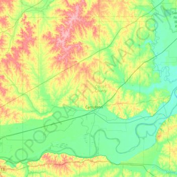
Name: Carroll County topographic map, elevation, terrain.
Location: Carroll County, Missouri, United States (39.20607 -93.75904 39.61563 -93.10449)
Average elevation: 741 ft
Minimum elevation: 627 ft
Maximum elevation: 1,004 ft
Missouri trails, hiking, mountain biking, running and outdoor activities
Other topographic maps
Click on a map to view its topography, its elevation and its terrain.
Creve Coeur Lake
United States > Missouri > Saint Louis County > Maryland Heights
Average elevation: 492 ft