
Manatee County topographic map
Click on the map to display elevation.
Manatee County
Manatee County features a varied topography characterized by flat coastal plains, gently rolling hills, and numerous waterways. The county’s landscape is predominantly low-lying, with elevations typically ranging from sea level to about 100 feet above sea level, making it susceptible to flooding during heavy rains or hurricanes. The region is crisscrossed by rivers such as the Manatee River and numerous creeks, which create a network of estuaries and wetlands that support diverse ecosystems. Coastal areas boast sandy beaches along the Gulf of Mexico, while inland regions are dotted with lush vegetation, including pine forests and swamps. This combination of terrain provides both scenic beauty and a habitat for various wildlife, contributing to the area’s rich biodiversity.
About this map
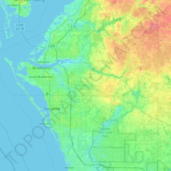
Name: Manatee County topographic map, elevation, terrain.
Location: Manatee County, Florida, United States (27.20798 -82.82303 27.64668 -82.05435)
Average elevation: 43 ft
Minimum elevation: -7 ft
Maximum elevation: 200 ft
Florida trails, hiking, mountain biking, running and outdoor activities
Other topographic maps
Click on a map to view its topography, its elevation and its terrain.
Palm Harbor
United States > Florida > Pinellas County
Palm Harbor is characterized by its unique topography, which features a relatively rare hilly landscape for the region. Unlike much of the surrounding areas in Pinellas County, which are predominantly flat, Palm Harbor includes elevations that can reach up to about 75 feet above sea level. This elevation gives…
Average elevation: 30 ft
Parrish
United States > Florida > Manatee County
Parrish features a predominantly flat terrain with an average elevation of approximately 36 feet above sea level. The area's landscape is characterized by gently rolling hills and low-lying regions, making it typical of the Central Florida topography. Surrounding Parrish are numerous wetlands and drainage…
Average elevation: 39 ft
Jacksonville
United States > Florida > Duval County > Jacksonville
Just south of Jacksonville and north of Saint Augustine is the boundary of where the Floridian Peninsula ends and Continental North America begins; Jacksonville is north of that line. While still in the North American Coastal plain, the topography begins to take on slight Piedmont characteristics. Like the…
Average elevation: 30 ft
Port Charlotte
United States > Florida > Charlotte County
Port Charlotte is characterized by a predominantly flat and low-lying terrain, typical of Florida’s coastal landscape. The area features a network of waterways, including the Peace River and Charlotte Harbor, which provide ample opportunities for recreational activities like boating and fishing. Elevations…
Average elevation: 13 ft
Navarre
United States > Florida > Santa Rosa County
Navarre is located at 30°24′04″N 86°51′47″W / 30.401°N 86.863°W / 30.401; -86.863Coordinates: 30°24′04″N 86°51′47″W / 30.401°N 86.863°W / 30.401; -86.863. It is located within a portion of the Florida Panhandle observing the Central Time Zone. Elevation is at an average of 10 feet (3.0 m).
Average elevation: 13 ft
Lutz
United States > Florida > Hillsborough County > Tampa
Lutz is characterized by a gently rolling topography that showcases the distinctive features of the central Florida landscape. The area has an average elevation of about 70 feet (21 meters) above sea level, contributing to its mild undulations rather than dramatic elevation changes. The terrain is marked by a…
Average elevation: 66 ft
Englewood
United States > Florida > Sarasota County > Englewood
Englewood features predominantly flat and low-lying terrain typical of the region's coastal landscape. The average elevation here is approximately 15 feet above sea level, which makes the area particularly susceptible to tidal influences and storm surges. The terrain is interspersed with wetlands and…
Average elevation: 10 ft
Ponte Vedra Beach
United States > Florida > Saint Johns County > Ponte Vedra Beach
Ponte Vedra Beach is characterized by its gently rolling terrain that is primarily flat and lies only about 15 feet above sea level. The landscape is predominantly shaped by coastal dunes and the proximity to the Atlantic Ocean, resulting in sandy beaches interspersed with vegetation typical of barrier island…
Average elevation: 10 ft
Anna Maria island
United States > Florida > Manatee County
Anna Maria Island features a flat, sandy topography typical of a barrier island on the Gulf Coast. With an average elevation of around 15 feet above sea level, the terrain includes broad beaches, low dunes, and narrow stretches of sandy soil, making it highly vulnerable to storm surges and tidal flooding. The…
Average elevation: 7 ft
Nokomis
United States > Florida > Sarasota County
Nokomis features a predominantly flat and low-lying terrain characteristic of the coastal region. The elevation in Nokomis rarely exceeds 15 feet above sea level, contributing to its vulnerability to tidal influences and storm surges. The area is interspersed with wetlands and mangroves, particularly near the…
Average elevation: 16 ft
The Lil' Saint John's River
United States > Florida > Duval County > Jacksonville Beach
Average elevation: 10 ft
Virginia Key Beach North Point Park
United States > Florida > Miami-Dade County > Miami
Average elevation: 10 ft
Shady Oaks Trailer Park
United States > Florida > Miami-Dade County > North Miami
Average elevation: 30 ft
Saint Petersburg County Park
United States > Florida > Pinellas County > Saint Pete Beach
Average elevation: 3 ft
L C Ringhaver Park
United States > Florida > Duval County > Jacksonville > Venetia Terrace
Average elevation: 16 ft
Peace River Botanical & Sculpture Gardens
United States > Florida > Charlotte County > Punta Gorda
Average elevation: 10 ft
Kings Point Heritage Park
United States > Florida > Hillsborough County > Sun City Center
Average elevation: 52 ft