
Loon Lake topographic map
Click on the map to display elevation.
About this map
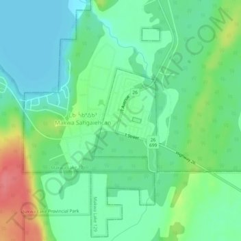
Name: Loon Lake topographic map, elevation, terrain.
Location: Loon Lake, Saskatchewan, Canada (54.02054 -109.16572 54.03220 -109.15360)
Average elevation: 1,795 ft
Minimum elevation: 1,719 ft
Maximum elevation: 1,962 ft
Other topographic maps
Click on a map to view its topography, its elevation and its terrain.
McClean Lake
Canada > Saskatchewan > Division No. 18 > Unorganized Division No. 18
Average elevation: 1,444 ft
Grasslands National Park of Canada
Canada > Saskatchewan > Waverley No. 44
Average elevation: 2,694 ft
Onion Lake
Canada > Saskatchewan > Division No. 17 > Frenchman Butte No. 501
Average elevation: 2,024 ft
La Loche
Canada > Saskatchewan > Northern Saskatchewan Administration District > La Loche
Average elevation: 1,467 ft
Pelican Narrows
Canada > Saskatchewan > Northern Saskatchewan Administration District > Pelican Narrows
Average elevation: 1,053 ft