
Lake Superior topographic map
Interactive map
Click on the map to display elevation.
About this map
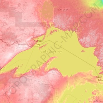
Name: Lake Superior topographic map, elevation, terrain.
Location: Lake Superior, United States (46.41024 -92.27277 49.01868 -84.35438)
Average elevation: 1,043 ft
Minimum elevation: 331 ft
Maximum elevation: 2,182 ft
American limnologist J. Val Klump was the first person to reach the lowest depth of Lake Superior on July 30, 1985, as part of a scientific expedition, which at 122 fathoms 1 foot (733 ft or 223 m) below sea level is the second-lowest spot in the continental interior of the United States and the third-lowest spot in the interior of the North American continent after Great Slave Lake in the Northwest Territories of Canada (1,503 feet[458 m] below sea level) and Iliamna Lake in Alaska (942 feet [287 m] below sea level). (Though Crater Lake is the deepest lake in the United States and deeper than Lake Superior, Crater Lake's elevation is higher and consequently its deepest point is 4,229 feet (1,289 m) above sea level.)
Other topographic maps
Click on a map to view its topography, its elevation and its terrain.
Houston
United States > Texas > Harris County
Houston, Harris County, Texas, United States
Average elevation: 82 ft
Sevierville
United States > Tennessee > Sevier County
Sevierville, Sevier County, East Tennessee, Tennessee, United States
Average elevation: 1,027 ft
Seattle
United States > Washington > King County
Seattle, King County, Washington, United States
Average elevation: 131 ft
Saint Petersburg
United States > Florida > Pinellas County
Saint Petersburg, Pinellas County, Florida, United States
Average elevation: 13 ft
Portland
United States > Oregon > Multnomah County
Portland, Multnomah County, Oregon, United States
Average elevation: 253 ft
Colorado Springs
United States > Colorado > El Paso County
Colorado Springs, El Paso County, Colorado, United States
Average elevation: 7,388 ft
San Diego
United States > California > San Diego County
San Diego, San Diego County, California, United States
Average elevation: 410 ft
Dallas
United States > Texas > Dallas County
Dallas, Dallas County, Texas, United States
Average elevation: 525 ft
San Antonio
United States > Texas > Bexar County
San Antonio, Bexar County, Texas, United States
Average elevation: 810 ft
Las Vegas
United States > Nevada > Clark County
Las Vegas, Clark County, Nevada, United States
Average elevation: 2,480 ft
Gatlinburg
United States > Tennessee > Sevier County
Gatlinburg, Sevier County, East Tennessee, Tennessee, 37738, United States
Average elevation: 1,893 ft
Denver
United States > Colorado > Denver County > Denver
Denver, Denver County, Colorado, United States
Average elevation: 5,525 ft
Miami
United States > Florida > Miami-Dade County
Miami, Miami-Dade County, Florida, United States
Average elevation: 16 ft
San Francisco
San Francisco, California, United States
Average elevation: 207 ft
Salt Lake City
United States > Utah > Salt Lake County
Salt Lake City, Salt Lake County, Utah, United States
Average elevation: 5,223 ft
Austin
United States > Texas > Travis County
Austin, Travis County, Texas, United States
Average elevation: 709 ft
Tallahassee
United States > Florida > Leon County
Tallahassee, Leon County, Florida, United States
Average elevation: 118 ft
Diamondhead
United States > Mississippi > Hancock County
Diamondhead, Hancock County, Mississippi, United States
Average elevation: 10 ft
Anne Arundel County
Anne Arundel County, Maryland, United States
Average elevation: 82 ft
Summerlin
United States > Nevada > Clark County > Las Vegas
Summerlin, Las Vegas, Clark County, Nevada, 89134, United States
Average elevation: 2,766 ft
Spokane
United States > Washington > Spokane County
Spokane, Spokane County, Washington, United States
Average elevation: 2,149 ft
Rochester
United States > Minnesota > Olmsted County
Rochester, Olmsted County, Minnesota, United States
Average elevation: 1,161 ft
Hendersonville
United States > North Carolina > Henderson County
Hendersonville, Henderson County, North Carolina, 28738, United States
Average elevation: 2,195 ft
Raleigh
United States > North Carolina > Wake County
Raleigh, Wake County, North Carolina, United States
Average elevation: 338 ft
Manhattan
United States > New York > New York County > New York
Manhattan, New York County, New York, United States
Average elevation: 52 ft
Quincy
United States > Massachusetts > Norfolk County
Quincy, Norfolk County, Massachusetts, United States
Average elevation: 62 ft
Saratoga Springs
United States > New York > Saratoga County > Saratoga Springs
Saratoga Springs, City of Saratoga Springs, Saratoga County, New York, 12866, United States
Average elevation: 528 ft
Phoenix
United States > Arizona > Maricopa County
Phoenix, Maricopa County, Arizona, United States
Average elevation: 1,578 ft
Chicago
United States > Illinois > Cook County
Chicago, Cook County, Illinois, United States
Average elevation: 597 ft
Cleveland
United States > Ohio > Cuyahoga County
Cleveland, Cuyahoga County, Ohio, United States
Average elevation: 705 ft
West Feliciana Parish
West Feliciana Parish, Louisiana, United States
Average elevation: 138 ft
Glacier National Park
United States > Montana > Flathead County
Glacier National Park, Flathead County, Montana, United States
Average elevation: 5,230 ft