
Make a donation
Gear up for your next adventure:
As an Amazon Associate, this site earns from qualifying purchases at no extra cost to you.
Torfaen topographic map
Click on the map to display elevation.
Make a donation
Gear up for your next adventure:
As an Amazon Associate, this site earns from qualifying purchases at no extra cost to you.
Torfaen
Exterior A large iron framed market hall with two full elevations and three secondary entrances through other street frontages, eg. Jubilee Building, Crane Street. Built of grey narrow coursed rock faced pennant limestone with some larger stones, and with yellow Ebbw Vale brick dressings and a Welsh slate roof. Single storey street elevations with windows onto secondary aisles which surround the main aisled hall. The Market Street elevation has a central doorway with four centred Tudor arch head. This has part glazed wooden doors with pilasters rising to a corbel frieze and a date panel 1893, and a parapet over with raised battlement type features at either end. This door is flanked on either side by four three-light windows with yellow brick frames and mullions. These are all in line, but the plinth below with yellow brick coping is stepped down the street. Additional doors flank these, again with pilasters but not rising to a parapet; then another three light window at the north end but only a single light one at the south corner. The end elevation has first a single light, then a two-light with king mullion, then five three-light windows, the most northerly one with a roundel in a gable above. The roofs behind these walls can be seen stepped up in three heights over the two aisles and the main nave. The nave roof has timber gable windows and glazing along the length of the roof on both slopes. Crane Street entrance: This has another Tudor doorway as above, but flanked by one over one windows in plain heads. Above the entrance is a crow-stepped gable with block at apex and a three light window with stepped head above the door. Gable has date 1894 and inscription PLB (Pontypool Local Board). Commercial Street entrance has another Tudor style doorway set into the ground floor of an early C19 terrace on the south west side of Commercial Street. Only the doorway and the dateplaque 1894 above it are late C19.
Make a donation
Gear up for your next adventure:
As an Amazon Associate, this site earns from qualifying purchases at no extra cost to you.
About this map
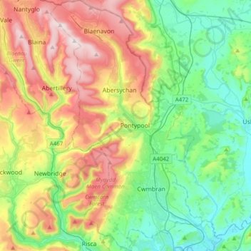
Name: Torfaen topographic map, elevation, terrain.
Location: Torfaen, Wales, United Kingdom (51.60667 -3.14392 51.79623 -2.95882)
Average elevation: 673 ft
Minimum elevation: 0 ft
Maximum elevation: 1,886 ft
Make a donation
Gear up for your next adventure:
As an Amazon Associate, this site earns from qualifying purchases at no extra cost to you.
Other topographic maps
Click on a map to view its topography, its elevation and its terrain.
Knighton
United Kingdom > Wales > Powys
The town became a borough in 1203, with a charter permitting a weekly market and annual fair. The presence of two castles within a comparatively small town suggests that one (the earlier motte and bailey sited atop the town) went out of use before the establishment of the second (the motte with no bailey at…
Average elevation: 968 ft
Make a donation
Gear up for your next adventure:
As an Amazon Associate, this site earns from qualifying purchases at no extra cost to you.
Make a donation
Gear up for your next adventure:
As an Amazon Associate, this site earns from qualifying purchases at no extra cost to you.
Make a donation
Gear up for your next adventure:
As an Amazon Associate, this site earns from qualifying purchases at no extra cost to you.
Make a donation
Gear up for your next adventure:
As an Amazon Associate, this site earns from qualifying purchases at no extra cost to you.
Cwm Idwal
United Kingdom > Wales > Gwynedd
Cwm Idwal is a cirque (or corrie) in the Glyderau range of mountains in northern Snowdonia, the national park in the mountainous region of North Wales. Its main interest is to hill walkers and rock climbers, but it is also of interest to geologists and naturalists, given its combination of altitude (relatively…
Average elevation: 1,969 ft
Make a donation
Gear up for your next adventure:
As an Amazon Associate, this site earns from qualifying purchases at no extra cost to you.
Make a donation
Gear up for your next adventure:
As an Amazon Associate, this site earns from qualifying purchases at no extra cost to you.
Make a donation
Gear up for your next adventure:
As an Amazon Associate, this site earns from qualifying purchases at no extra cost to you.
Make a donation
Gear up for your next adventure:
As an Amazon Associate, this site earns from qualifying purchases at no extra cost to you.
Make a donation
Gear up for your next adventure:
As an Amazon Associate, this site earns from qualifying purchases at no extra cost to you.
Make a donation
Gear up for your next adventure:
As an Amazon Associate, this site earns from qualifying purchases at no extra cost to you.
Make a donation
Gear up for your next adventure:
As an Amazon Associate, this site earns from qualifying purchases at no extra cost to you.
Make a donation
Gear up for your next adventure:
As an Amazon Associate, this site earns from qualifying purchases at no extra cost to you.
Make a donation
Gear up for your next adventure:
As an Amazon Associate, this site earns from qualifying purchases at no extra cost to you.
Make a donation
Gear up for your next adventure:
As an Amazon Associate, this site earns from qualifying purchases at no extra cost to you.
Make a donation
Gear up for your next adventure:
As an Amazon Associate, this site earns from qualifying purchases at no extra cost to you.
Make a donation
Gear up for your next adventure:
As an Amazon Associate, this site earns from qualifying purchases at no extra cost to you.
Welshpool
United Kingdom > Wales > Powys
The Mermaid Inn, 28 High Street, was very probably an early 16th-century merchant's house, placed on a burgage plot between the High Street and Alfred Jones Court. The timber-framed building has long storehouse or wing to the rear. The frontage was remodelled c. 1890, by Frank H. Shayler, architect, of…
Average elevation: 512 ft
Make a donation
Gear up for your next adventure:
As an Amazon Associate, this site earns from qualifying purchases at no extra cost to you.
Make a donation
Gear up for your next adventure:
As an Amazon Associate, this site earns from qualifying purchases at no extra cost to you.
Make a donation
Gear up for your next adventure:
As an Amazon Associate, this site earns from qualifying purchases at no extra cost to you.
Llanfairpwllgwyngyll
United Kingdom > Wales > Isle of Anglesey > Llanfairpwllgwyngyll
Average elevation: 138 ft
Make a donation
Gear up for your next adventure:
As an Amazon Associate, this site earns from qualifying purchases at no extra cost to you.
Make a donation
Gear up for your next adventure:
As an Amazon Associate, this site earns from qualifying purchases at no extra cost to you.
Make a donation
Gear up for your next adventure:
As an Amazon Associate, this site earns from qualifying purchases at no extra cost to you.
Make a donation
Gear up for your next adventure:
As an Amazon Associate, this site earns from qualifying purchases at no extra cost to you.
Make a donation
Gear up for your next adventure:
As an Amazon Associate, this site earns from qualifying purchases at no extra cost to you.
Make a donation
Gear up for your next adventure:
As an Amazon Associate, this site earns from qualifying purchases at no extra cost to you.