
Make a donation
Gear up for your next adventure:
As an Amazon Associate, this site earns from qualifying purchases at no extra cost to you.
Sangrur topographic map
Click on the map to display elevation.
Make a donation
Gear up for your next adventure:
As an Amazon Associate, this site earns from qualifying purchases at no extra cost to you.
About this map
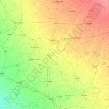
Name: Sangrur topographic map, elevation, terrain.
Location: Sangrur, Punjab, India (29.72672 75.55559 30.54484 76.20386)
Average elevation: 768 ft
Minimum elevation: 692 ft
Maximum elevation: 866 ft
Make a donation
Gear up for your next adventure:
As an Amazon Associate, this site earns from qualifying purchases at no extra cost to you.
Other topographic maps
Click on a map to view its topography, its elevation and its terrain.
Make a donation
Gear up for your next adventure:
As an Amazon Associate, this site earns from qualifying purchases at no extra cost to you.
Make a donation
Gear up for your next adventure:
As an Amazon Associate, this site earns from qualifying purchases at no extra cost to you.
Make a donation
Gear up for your next adventure:
As an Amazon Associate, this site earns from qualifying purchases at no extra cost to you.
Hoshiarpur
India > Punjab > Hoshiarpur Tahsil
Hoshiarpur has an average elevation of 296 metres (971 ft). Hoshiarpur district is located in the north-east part of the Indian state of Punjab. It falls in the Jalandhar Revenue Division and is situated in the Bist Doab portion of the Doaba region. Hoshiarpur shares a boundary with Kangra district, and Una…
Average elevation: 1,073 ft
Make a donation
Gear up for your next adventure:
As an Amazon Associate, this site earns from qualifying purchases at no extra cost to you.
Make a donation
Gear up for your next adventure:
As an Amazon Associate, this site earns from qualifying purchases at no extra cost to you.
Make a donation
Gear up for your next adventure:
As an Amazon Associate, this site earns from qualifying purchases at no extra cost to you.
Bathinda
India > Punjab > Bathinda Tahsil
Bathinda is in the northwestern region of India and is a part of the Indo-Gangetic alluvial plains. The exact cartographic co-ordinates of Bathinda are 30°12′N 74°57′E / 30.20°N 74.95°E / 30.20; 74.95. It has an average elevation of 201 metres (660 ft).
Average elevation: 682 ft
Make a donation
Gear up for your next adventure:
As an Amazon Associate, this site earns from qualifying purchases at no extra cost to you.
Make a donation
Gear up for your next adventure:
As an Amazon Associate, this site earns from qualifying purchases at no extra cost to you.
Khamanon
India > Punjab > Khamanon Tahsil
Khamanon is located at 30°49′N 76°21′E / 30.82°N 76.35°E / 30.82; 76.35. It has an average elevation of 254 metres (833 feet).
Average elevation: 899 ft
Make a donation
Gear up for your next adventure:
As an Amazon Associate, this site earns from qualifying purchases at no extra cost to you.
Mukerian
India > Punjab > Mukerian Tahsil
Mukerian is located at 31°57′N 75°37′E / 31.95°N 75.62°E / 31.95; 75.62. It has an average elevation of 245 metres (804 ft).
Average elevation: 846 ft
Make a donation
Gear up for your next adventure:
As an Amazon Associate, this site earns from qualifying purchases at no extra cost to you.
Make a donation
Gear up for your next adventure:
As an Amazon Associate, this site earns from qualifying purchases at no extra cost to you.
Rajpura
India > Punjab > Rajpura Tahsil
Rajpura is located at 30°29′N 76°36′E / 30.48°N 76.6°E / 30.48; 76.6. It has an average elevation of 259 metres (849 feet). Rajpura is situated nearly 38 km south west of Chandigarh, the capital city of Punjab. Besides being an important industrial town of Punjab, it also has historical importance.
Average elevation: 886 ft
Make a donation
Gear up for your next adventure:
As an Amazon Associate, this site earns from qualifying purchases at no extra cost to you.
Make a donation
Gear up for your next adventure:
As an Amazon Associate, this site earns from qualifying purchases at no extra cost to you.
Patiala
India > Punjab > Patiala Tahsil > Patiala
Patiala is located at 30°19′N 76°24′E / 30.32°N 76.40°E / 30.32; 76.40. It has an average elevation of 250 metres (820 feet). During the short existence of PEPSU, Patiala served as its capital city.
Average elevation: 837 ft
Make a donation
Gear up for your next adventure:
As an Amazon Associate, this site earns from qualifying purchases at no extra cost to you.
Kartarpur
India > Punjab > Jalandhar II Tahsil > Kartarpur
Kartarpur is located at 31°26′N 75°30′E / 31.44°N 75.5°E / 31.44; 75.5. It has an average elevation of 228 metres (748 feet). It is situated at a distance of 15 km from Jalandhar towards Amritsar on G.T. Road (National Highway 1).
Average elevation: 774 ft
Make a donation
Gear up for your next adventure:
As an Amazon Associate, this site earns from qualifying purchases at no extra cost to you.
Make a donation
Gear up for your next adventure:
As an Amazon Associate, this site earns from qualifying purchases at no extra cost to you.
Make a donation
Gear up for your next adventure:
As an Amazon Associate, this site earns from qualifying purchases at no extra cost to you.