Geolocate

Turk Mountain topographic map

Click on the map to display elevation.

About this map

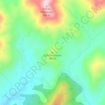
Name: Turk Mountain topographic map, elevation, terrain.

Location: Turk Mountain, Nelson County, Virginia, United States (37.88620 -78.77424 37.88630 -78.77414)

Average elevation: 1,014 ft

Minimum elevation: 614 ft

Maximum elevation: 1,850 ft

Virginia trails, hiking, mountain biking, running and outdoor activities

Other topographic maps

Click on a map to view its topography, its elevation and its terrain.

Stumpy Lake

United States > Virginia > Virginia Beach > Glenwood

Average elevation: 23 ft

Great Falls

United States > Virginia > Fairfax County > Great Falls

Great Falls is located at 38°59′53″N 077°17′18″W / 38.99806°N 77.28833°W / 38.99806; -77.28833 (38.9981653, −77.2883157) at an elevation of 344 feet (105 m). Located on Virginia State Route 7 in Northern Virginia, Great Falls is 15 miles (24 km) west-northwest of downtown Washington,…

Average elevation: 289 ft

Carroll County

United States > Virginia

The first European settlers arrived in the region in the mid 18th century. These were primarily Scotch-Irish pioneers, who were used to high mountain altitudes. However, early settlement was slow, mostly due to the poor agricultural soil of the area. As a result, lead mining was one of the first economic…

Average elevation: 2,326 ft

Lake Gaston

United States > Virginia > Mecklenburg County

Average elevation: 312 ft

Hollymead

United States > Virginia > Albemarle County

Average elevation: 489 ft

Lake Braddock

United States > Virginia > Fairfax County > Burke

Average elevation: 318 ft

Lee County

United States > Virginia

The county contains karst, a type of topography, within an area of Ordovician limestone called "the Cedars." The Powell River flows through Lee County on its way to Tennessee.

Average elevation: 1,798 ft

New River

United States > Virginia

Average elevation: 2,080 ft

Blue Ridge

United States > Virginia > Loudoun County

Blue Ridge Mountain is noticeably lower in elevation than other sections of the Blue Ridge Mountains in Virginia. The southern section of the mountain contains the highest peaks, and the ridge gradually loses elevation as it gets closer to the Potomac. Elevations in the gaps are typically around 1,000 feet…

Average elevation: 600 ft

Southampton County

United States > Virginia

Average elevation: 79 ft

Alleghany County

United States > Virginia

Average elevation: 2,064 ft

Bedford County

United States > Virginia

Average elevation: 715 ft

Buchanan County

United States > Virginia

Average elevation: 1,870 ft

Orange County

United States > Virginia

According to the U.S. Census Bureau, the county has a total area of 343 square miles (890 km2), of which 341 square miles (880 km2) is land and 2.5 square miles (6.5 km2) (0.7%) is water. The terrain is characterized by rolling hills, generally increasing in altitude and slope as they continue westward toward…

Average elevation: 436 ft

Lake Dillon

United States > Virginia

Average elevation: 256 ft

Picnic Grove

United States > Virginia

Average elevation: 587 ft

Norton

United States > Virginia

Average elevation: 2,608 ft

Piankatank River

United States > Virginia

Average elevation: 0 ft

Middlesex County

United States > Virginia

Average elevation: 49 ft

Bedford

United States > Virginia > Bedford County

Average elevation: 935 ft

Russell County

United States > Virginia

Average elevation: 2,172 ft

Richmond County

United States > Virginia

Average elevation: 72 ft

Northampton County

United States > Virginia

Average elevation: 3 ft

Essex County

United States > Virginia

Average elevation: 98 ft

Lancaster County

United States > Virginia

Average elevation: 43 ft

Surry County

United States > Virginia

Average elevation: 69 ft

Cape Charles

United States > Virginia > Northampton County

Cape Charles lies on a peninsula and is surrounded by water on three sides. The town is situated directly on the Chesapeake Bay, bordered by King's Creek to the north and Old Plantation Creek to the south. The land in town is low lying and relatively flat, with the highest point of elevation at 15 feet, and a…

Average elevation: 7 ft

Tazewell

United States > Virginia > Tazewell County

Average elevation: 2,641 ft

Gwynn's Island

United States > Virginia > Mathews County > Gwynn

Average elevation: 7 ft

Hogan Lake

United States > Virginia > Pulaski County

Average elevation: 2,365 ft

Conner Lake

United States > Virginia > Halifax County

Average elevation: 427 ft

Grays Creek

United States > Virginia > Surry County

Average elevation: 39 ft

Laurel Fork

United States > Virginia > Carroll County

Average elevation: 2,530 ft

Painter

United States > Virginia > Accomack County

It lies at an elevation of 36 feet.

Average elevation: 33 ft

Ivor

United States > Virginia > Southampton County

Average elevation: 82 ft

Mount Sidney

United States > Virginia > Augusta County

Average elevation: 1,319 ft

Clinchport

United States > Virginia > Scott County

Average elevation: 1,499 ft

King George

United States > Virginia > King George County

Average elevation: 148 ft

Cascades

United States > Virginia > Loudoun County

Average elevation: 256 ft

Blakey Ridge

United States > Virginia > Madison County

Average elevation: 1,362 ft

Hanover

United States > Virginia > Hanover County > Hanover

Average elevation: 95 ft

Victoria

United States > Virginia > Lunenburg County

Average elevation: 528 ft

Belle Haven

United States > Virginia > Accomack County

Average elevation: 26 ft

Lake Chesdin

United States > Virginia > Dinwiddie County

Average elevation: 230 ft

Amelia Lake

United States > Virginia > Amelia County

Average elevation: 285 ft

Rose Hill

United States > Virginia > Fairfax County

Average elevation: 171 ft

Laurel Fork

United States > Virginia > Carroll County

Average elevation: 2,638 ft

Ware Creek

United States > Virginia > James City County

Average elevation: 30 ft

Parrott

United States > Virginia > Pulaski County

Average elevation: 1,982 ft

Kilmarnock

United States > Virginia > Lancaster County

Average elevation: 52 ft

Ivy

United States > Virginia > Albemarle County

Average elevation: 614 ft

Lawrenceville

United States > Virginia > Brunswick County

Average elevation: 223 ft

Hays Creek

United States > Virginia > Rockbridge County

Average elevation: 1,437 ft

Radford City

United States > Virginia > Radford City

Average elevation: 1,916 ft

Vinton

United States > Virginia > Roanoke County

Vinton has varied topography, considering its 3.2 square mile size. The above-mentioned lake is at an elevation of 890 feet (270 m) above sea level. The Vinton side of the lake consists of a steep, wooded cliff 150 feet (46 m) in vertical height. Vinton's highest point is on Olney Road, at an elevation of…

Average elevation: 1,001 ft

Toms Brook

United States > Virginia > Shenandoah County

Average elevation: 761 ft

Tappahannock

United States > Virginia > Essex County

Average elevation: 20 ft

Pimmit Hills

United States > Virginia > Fairfax County

Average elevation: 367 ft

Triangle

United States > Virginia > Prince William County

Average elevation: 141 ft

Dooms

United States > Virginia > Augusta County

Average elevation: 1,444 ft

Jolivue

United States > Virginia > Augusta County

Average elevation: 1,562 ft

North Shore

United States > Virginia > Franklin County > Scruggs

Average elevation: 856 ft

Montrose

United States > Virginia > Henrico County

Average elevation: 144 ft

Sudley

United States > Virginia > Prince William County

Average elevation: 210 ft

Merrimac

United States > Virginia > Montgomery County > Merrimac

Average elevation: 2,083 ft

Craigsville

United States > Virginia > Augusta County

Average elevation: 1,703 ft

Iron Gate

United States > Virginia > Alleghany County

Average elevation: 1,217 ft

Low Moor

United States > Virginia > Alleghany County

Average elevation: 1,463 ft

Troutville

United States > Virginia > Botetourt County

Average elevation: 1,503 ft

Rapidan River

United States > Virginia > Culpeper County

Average elevation: 269 ft

Brandy Station

United States > Virginia > Culpeper County

Average elevation: 338 ft

Gear up for your next adventure:

🎒Day Hiking Backpack - Lightweight backpack perfect for day trips and outdoor adventures
🧤Hiking Gloves - Protective gloves for rugged trails
🍳Camping Cook Set - Complete cookware for outdoor meals
🧥Men's Rain Shells - Premium waterproof and breathable jackets for mountain weather
👖Convertible Hiking Pants - Versatile zip-off pants for changing altitudes and temperatures

As an Amazon Associate, this site earns from qualifying purchases at no extra cost to you.