
万柏林区 topographic map
Interactive map
Click on the map to display elevation.
About this map
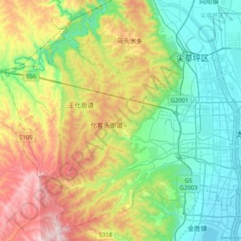
Name: 万柏林区 topographic map, elevation, terrain.
Location: 万柏林区, 太原市, 山西省, 中国 (37.78120 112.25677 37.98209 112.53694)
Average elevation: 3,678 ft
Minimum elevation: 2,536 ft
Maximum elevation: 6,070 ft
万柏林区境内地形西高东低,西部为山地,东部为带状平川,地质构造属西山向斜盆地,汾河流域陷落区。气候属北温带大陆性季风气候。地下蕴藏有丰富的煤炭、石膏、铝矾土等矿产资源。汾河蜿蜒流过区境东部,玉门河、虎峪河、九院沙河三条边山支河由西向东汇入洽河。
Other topographic maps
Click on a map to view its topography, its elevation and its terrain.