
Pallpata topographic map
Click on the map to display elevation.
About this map
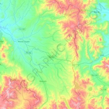
Name: Pallpata topographic map, elevation, terrain.
Location: Pallpata, Espinar, Cusco, Perú (-15.16603 -71.28838 -14.72295 -70.97489)
Average elevation: 14,009 ft
Minimum elevation: 12,799 ft
Maximum elevation: 16,460 ft
Other topographic maps
Click on a map to view its topography, its elevation and its terrain.
Cuzco
Una de las características que lograron los Incas con su plan urbano en el Cusco fue el respeto por la matriz geográfica a la hora de construir su tejido, ya que respondieron con diferentes estrategias de diseño a la topografía accidentada propia de la zona andina a 3399 metros sobre el nivel del mar.
Average elevation: 12,434 ft
Laguna Piuray
Perú > Cusco > Chinchero > Pongobamba
La laguna Piuray es una fuente de agua o laguna de origen superficial ubicada en la Cordillera Vilcanota en la región Cusco en Perú, tiene un color azul oscuro que refleja el inmenso cielo andino. Está situada a 31 kilómetros de la ciudad de Cusco, a una altitud de 3 435 m s. n. m.
Average elevation: 12,221 ft
Pongo de Mainique
El pongo de Mainique es una brecha de agua del río Urubamba en el Perú. Dentro del espacio de agua, el río está restringido a un ancho de 45 m. El pongo de Mainique tiene 3 km de largo. La elevación del río es de aproximadamente 450 m s. n. m. La altitud de los acantilados en ambos lados del río es de…
Average elevation: 2,513 ft
Machupicchu Pueblo
Perú > Cusco > Machupicchu
Machupicchu Pueblo se encuentra en la región yunga de la selva, a una altitud de 2040 m s. n. m. (metros sobre el nivel del mar). El pueblo está situado a orillas del río Urubamba, en la desembocadura de los ríos Aguas Calientes y Alcamayo hacia el primero. Machupicchu está rodeado de montañas de granito…
Average elevation: 8,986 ft