
South Dakota topographic map
Interactive map
Click on the map to display elevation.
South Dakota
South Dakota's topography is characterized by a striking contrast between its eastern and western regions. The eastern part features gently rolling hills and fertile plains, which are part of the Great Plains, known for their rich agricultural lands, particularly ideal for crops like wheat and corn. As one moves westward, the terrain transitions into more rugged landscapes, dominated by the Black Hills, where granite peaks rise steeply to elevations of over 7,000 feet. This mountain range includes South Dakota's highest point, Black Elk Peak, at 7,242 feet. Notably, the Badlands National Park showcases a dramatic landscape of sharply eroded canyons and colorful rock formations, formed by the relentless forces of erosion over millions of years. The state's varied topography not only creates a breathtaking natural environment but also supports diverse ecosystems and plays a significant role in its cultural and economic development.
About this map
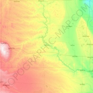
Name: South Dakota topographic map, elevation, terrain.
Location: South Dakota, United States (42.47989 -104.05776 45.94534 -96.43634)
Average elevation: 2,352 ft
Minimum elevation: 899 ft
Maximum elevation: 7,106 ft
United States trails, hiking, mountain biking, running and outdoor activities
Other topographic maps
Click on a map to view its topography, its elevation and its terrain.
San Diego
United States > California > San Diego County > San Diego
The climate in San Diego, like most of Southern California, often varies significantly over short geographical distances, resulting in microclimates. In San Diego, this is mostly because of the city's topography (the Bay, and the numerous hills, mountains, and canyons). Frequently, particularly during the "May…
Average elevation: 187 ft
San Francisco Bay Area
United States > California > San Francisco
The San Francisco Bay Area is characterized by a diverse and dynamic topography shaped by geological processes over millions of years. This region features a combination of coastal plains, steep hills, and rugged mountains, all influenced by the tectonic activity associated with the nearby San Andreas Fault…
Average elevation: 371 ft
Scottsdale
United States > Arizona > Maricopa County > Scottsdale
The city is in the Salt River Valley, or the "Valley of the Sun," in the northern reaches of the Sonoran Desert. Scottsdale, 31 mi (50 km) long and 11.4 mi (18.3 km) wide at its widest point, shares boundaries with many other municipalities and entities. On the west, Scottsdale is bordered by Phoenix, Paradise…
Average elevation: 1,358 ft
Maple Grove Corners
United States > Michigan > Van Buren County > South Haven Charter Township
Average elevation: 646 ft
Central Park
United States > New York > New York County > New York
In June 1856, Fernando Wood appointed a "consulting board" of seven people, headed by author Washington Irving, to inspire public confidence in the proposed development. Wood hired military engineer Egbert Ludovicus Viele as the park's chief engineer, tasking him with a topographical survey of the site. The…
Average elevation: 85 ft
West Saint Johnsville
United States > New York > Montgomery County > Town of Saint Johnsville
Average elevation: 495 ft
Charlotte Lake
United States > California > Fresno County
Charlotte Lake (also known as Charlotta Lake, or Rhoda Lake) is a lake in the Sierra Nevada, located in Kings Canyon National Park, eastern Fresno County, California. The lake is located on the John Muir Trail, at an elevation of 10,544 feet (3,214 m).
Average elevation: 10,932 ft
Baltimore
United States > Maryland > Baltimore
Baltimore is in north-central Maryland on the Patapsco River close to where it empties into the Chesapeake Bay. The city is also located on the fall line between the Piedmont Plateau and the Atlantic coastal plain, which divides Baltimore into "lower city" and "upper city". The city's elevation ranges from sea…
Average elevation: 213 ft
Little Bear Island
United States > New Hampshire > Carroll County > Tuftonboro
Average elevation: 525 ft
Central Highlands
United States > Pennsylvania > Allegheny County > Elizabeth Township
Average elevation: 1,073 ft
Columbus
United States > Ohio > Franklin County > Columbus
The confluence of the Scioto and Olentangy rivers is just north-west of Downtown Columbus. Several smaller tributaries course through the Columbus metropolitan area, including Alum Creek, Big Walnut Creek, and Darby Creek. Columbus is considered to have relatively flat topography thanks to a large glacier that…
Average elevation: 837 ft
Hein Trails
United States > Connecticut > South Central Connecticut Planning Region > Bethany > Davidsons Corner
Average elevation: 574 ft
Sierra Blanca
United States > Texas > Hudspeth County
Sierra Blanca is found in Far West Texas, a subdivision of West Texas, and is 4,520 feet (1,380 m) above sea level. The town is part of the Trans-Pecos region within the most mountainous and arid portion of Texas. The town is located in Hudspeth County, which is large and sparsely populated. Sierra Blanca…
Average elevation: 4,564 ft
Appalachian Mountains
United States > North Carolina > Yancey County
The Appalachian Mountains (French: Appalaches), often called the Appalachians, are a system of mountains in eastern to northeastern North America. The Appalachians first formed roughly 480 million years ago during the Ordovician Period. They once reached elevations similar to those of the Alps and the Rocky…
Average elevation: 4,800 ft
Rocky Mountains
United States > Wyoming > Teton County
Agriculture and forestry are major industries. Agriculture includes dryland and irrigated farming and livestock grazing. Livestock are frequently moved between high-elevation summer pastures and low-elevation winter pastures, a practice known as transhumance.
Average elevation: 7,520 ft
Nineacre Island
United States > New Hampshire > Carroll County > Moultonborough
Average elevation: 518 ft
Silver Beach
United States > Connecticut > South Central Connecticut Planning Region > Milford
Average elevation: 16 ft
Beartrap Lake
United States > Wisconsin > Washburn County > Town of Birchwood
Average elevation: 1,414 ft
Drakeville
United States > Connecticut > Northwest Hills Planning Region > Torrington
Average elevation: 1,014 ft
Chimney Point
United States > Connecticut > Western Connecticut Planning Region > New Milford
Average elevation: 466 ft
Grand Staircase
United States > Connecticut > Northwest Hills Planning Region > Kent
Average elevation: 673 ft
Farmdale
United States > Pennsylvania > Lancaster County > West Hempfield Township
Average elevation: 430 ft
Anna Maria island
United States > Florida > Manatee County
Anna Maria Island features a flat, sandy topography typical of a barrier island on the Gulf Coast. With an average elevation of around 15 feet above sea level, the terrain includes broad beaches, low dunes, and narrow stretches of sandy soil, making it highly vulnerable to storm surges and tidal flooding. The…
Average elevation: 7 ft
Wesley Chapel
United States > Florida > Pasco County
According to the United States Census Bureau, the CDP has a total area of 6.1 square miles (16 km2), of which 6.1 square miles (16 km2) is land and 0.04 square miles (0.10 km2) (0.49%) is water. The elevation is about 100 feet (30 m), combined with an inland location, creates more temperature variation in the…
Average elevation: 62 ft
Georgetown
United States > Texas > Georgetown
The city is located on the northeastern edge of Texas Hill Country. Portions of Georgetown are located on either side of the Balcones Escarpment, a fault line in which the areas roughly east of IH-35 are flat and characterized by having black, fertile soils of the Blackland Prairie, and the west side of the…
Average elevation: 719 ft
Crested Butte
United States > Colorado > Gunnison County
Crested Butte is located in north-central Gunnison County on the west side of the valley of the Slate River, along Coal Creek. Colorado State Highway 135 runs south from Crested Butte 27 miles (43 km) to Gunnison, the county seat. According to the United States Census Bureau, the town of Crested Butte has a…
Average elevation: 9,180 ft
Mount Hood
United States > Oregon > Hood River County
Timberline Lodge is a National Historic Landmark located on the southern flank of Mount Hood just below Palmer Glacier, with an elevation of about 6,000 ft (1,800 m).
Average elevation: 8,911 ft
Mauna Kea
United States > Hawaii > Hawaiʻi County
Mauna Kea (/ˌmaʊnə ˈkeɪə/; Hawaiian: [ˈmɐwnə ˈkɛjə]; abbreviation for Mauna a Wākea) is a dormant volcano on the island of Hawaiʻi. Its peak is 4,207.3 m (13,803 ft) above sea level, making it the highest point in the state of Hawaiʻi and second-highest peak of an island on Earth. The peak is…
Average elevation: 13,051 ft
Appalachian Mountains
United States > North Carolina > Yancey County
The Appalachian Mountains (French: Appalaches), often called the Appalachians, are a system of mountains in eastern to northeastern North America. The Appalachians first formed roughly 480 million years ago during the Ordovician Period. They once reached elevations similar to those of the Alps and the Rocky…
Average elevation: 4,800 ft
Black Cat Island
United States > New Hampshire > Carroll County > Moultonborough
Average elevation: 512 ft
Loch Lomond Junction
United States > Pennsylvania > Centre County > Rush Township
Average elevation: 1,509 ft
Saugatuck
United States > Connecticut > Western Connecticut Planning Region > Westport
Average elevation: 49 ft
North Mianus
United States > Connecticut > Western Connecticut Planning Region > Greenwich
Average elevation: 105 ft