Geolocate

South Dakota topographic map

Click on the map to display elevation.

South Dakota

South Dakota's topography is characterized by a striking contrast between its eastern and western regions. The eastern part features gently rolling hills and fertile plains, which are part of the Great Plains, known for their rich agricultural lands, particularly ideal for crops like wheat and corn​. As one moves westward, the terrain transitions into more rugged landscapes, dominated by the Black Hills, where granite peaks rise steeply to elevations of over 7,000 feet​. This mountain range includes South Dakota's highest point, Black Elk Peak, at 7,242 feet​. Notably, the Badlands National Park showcases a dramatic landscape of sharply eroded canyons and colorful rock formations, formed by the relentless forces of erosion over millions of years​. The state's varied topography not only creates a breathtaking natural environment but also supports diverse ecosystems and plays a significant role in its cultural and economic development.

About this map

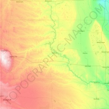
Name: South Dakota topographic map, elevation, terrain.

Location: South Dakota, United States (42.47989 -104.05776 45.94534 -96.43634)

Average elevation: 2,352 ft

Minimum elevation: 899 ft

Maximum elevation: 7,106 ft

United States trails, hiking, mountain biking, running and outdoor activities

Other topographic maps

Click on a map to view its topography, its elevation and its terrain.

San Antonio

United States > Texas > Bexar County > San Antonio

Average elevation: 715 ft

San Francisco Bay Area

United States > California > San Francisco

The San Francisco Bay Area is characterized by a diverse and dynamic topography shaped by geological processes over millions of years. This region features a combination of coastal plains, steep hills, and rugged mountains, all influenced by the tectonic activity associated with the nearby San Andreas Fault…

Average elevation: 371 ft

Englewood

United States > Florida > Sarasota County

Englewood features predominantly flat and low-lying terrain typical of the region's coastal landscape. The average elevation here is approximately 15 feet above sea level, which makes the area particularly susceptible to tidal influences and storm surges​. The terrain is interspersed with wetlands and…

Average elevation: 10 ft

Port Charlotte

United States > Florida > Charlotte County

Port Charlotte is characterized by a predominantly flat and low-lying terrain, typical of Florida’s coastal landscape. The area features a network of waterways, including the Peace River and Charlotte Harbor, which provide ample opportunities for recreational activities like boating and fishing. Elevations…

Average elevation: 13 ft

Mount Hood

United States > Oregon > Hood River County

Timberline Lodge is a National Historic Landmark located on the southern flank of Mount Hood just below Palmer Glacier, with an elevation of about 6,000 ft (1,800 m).

Average elevation: 8,911 ft

Graceland

United States > Tennessee > Shelby County > Memphis

Average elevation: 285 ft

El Dorado Hills

United States > California > El Dorado County > Cameron Park

El Dorado Hills (EDH), as defined by the 2010 census-designated place (CDP), is at the western border of El Dorado County, between the City of Folsom and the unincorporated community of Cameron Park. The northern limits of the CDP are Folsom Lake and the South Fork of the American River, where river rafters…

Average elevation: 833 ft

Hampton

United States > Tennessee > Carter County

Average elevation: 2,211 ft

Vail

United States > Arizona > Pima County > Vail

Average elevation: 3,396 ft

Mount Langley

United States > California > Tulare County

Average elevation: 12,464 ft

Sanibel Island

United States > Florida > Lee County > Sanibel

Average elevation: 3 ft

Superstition Mountains

United States > Arizona > Pinal County

Average elevation: 3,691 ft

Bailey

United States > Colorado > Park County

Average elevation: 8,517 ft

Santa Cruz Mountains

United States > California > Santa Clara County

The Santa Cruz Mountains are a region of great biological diversity, encompassing cool, moist coastal ecosystems as well as warm, dry chaparral. Much of the area in the Santa Cruz mountains is considered temperate rainforest. In valleys and moist ocean-facing slopes some of the southernmost coast redwoods…

Average elevation: 755 ft

Fallbrook

United States > California > San Diego County

Average elevation: 659 ft

Las Vegas

United States > Nevada

Average elevation: 3,031 ft

Columbus

United States > Ohio > Franklin County > Columbus

The confluence of the Scioto and Olentangy rivers is just north-west of Downtown Columbus. Several smaller tributaries course through the Columbus metropolitan area, including Alum Creek, Big Walnut Creek, and Darby Creek. Columbus is considered to have relatively flat topography thanks to a large glacier that…

Average elevation: 837 ft

Boston

United States > Massachusetts > Suffolk County > Boston

Boston has an area of 89.63 sq mi (232.1 km2)—48.4 sq mi (125.4 km2) (54%) of land and41.2 sq mi (106.7 km2) (46%) of water. The city's official elevation, as measured at Logan International Airport, is 19 ft (5.8 m) above sea level. The highest point in Boston is Bellevue Hill at 330 ft (100 m) above sea…

Average elevation: 85 ft

Midway Atoll

United States

Average elevation: 0 ft

Lemhi Pass

United States > Idaho > Lemhi County

Lemhi Pass is a high mountain pass in the Beaverhead Mountains, part of the Bitterroot Range in the Rocky Mountains and within Salmon-Challis National Forest. The pass lies on the Montana-Idaho border on the Continental Divide, at an elevation of 7,373 feet (2,247 m) above sea level. It is accessed via Lemhi…

Average elevation: 7,277 ft

Yuma

United States > Arizona > Yuma County

Average elevation: 226 ft

Jensen Beach

United States > Florida > Martin County

The Skyline Drive area includes some of the highest points in the community, reaching an elevation of 70 feet (21 m) at one point.

Average elevation: 16 ft

Avalanche Peak

United States > Wyoming > Park County

Average elevation: 9,472 ft

Haleakalā

United States > Hawaii > Maui County

Average elevation: 6,841 ft

Kapolei

United States > Hawaii > Honolulu County

Average elevation: 253 ft

Donner Pass

United States > California > Placer County

Average elevation: 7,100 ft

Anna Maria island

United States > Florida > Manatee County

Anna Maria Island features a flat, sandy topography typical of a barrier island on the Gulf Coast. With an average elevation of around 15 feet above sea level, the terrain includes broad beaches, low dunes, and narrow stretches of sandy soil, making it highly vulnerable to storm surges and tidal flooding. The…

Average elevation: 7 ft

Louisville

United States > Kentucky > Jefferson County > Louisville

Average elevation: 591 ft

Georgetown

United States > Texas > Georgetown

The city is located on the northeastern edge of Texas Hill Country. Portions of Georgetown are located on either side of the Balcones Escarpment, a fault line in which the areas roughly east of IH-35 are flat and characterized by having black, fertile soils of the Blackland Prairie, and the west side of the…

Average elevation: 719 ft

Ewa Beach

United States > Hawaii > Honolulu County

Average elevation: 20 ft

Queen Anne Hill

United States > Washington > King County > Seattle

Average elevation: 180 ft

Waipahu

United States > Hawaii > Honolulu County

There are several streams that run through Waipahu, including Waikele Stream and Kapakahi Stream. Waikele Stream runs along the Hawaii Plantation Village and down into Pouhala Marsh Wildlife Sanctuary, which is habitat for several endangered bird species that are endemic to Hawaii. There is roughly 140 feet of…

Average elevation: 538 ft

Old Mission

United States > Michigan > Grand Traverse County

Old Mission is located just east of M-37 near the tip of Old Mission Peninsula about 16 miles (25.75 km) north of Traverse City. The community was built along Old Mission Harbor, which is a small safe haven along the East Arm of Grand Traverse Bay. The community sits at an elevation of 587 feet (179 m) above…

Average elevation: 623 ft

Canyon Lake

United States > Texas > Comal County

Average elevation: 971 ft

Rio Rico

United States > Arizona > Santa Cruz County

Average elevation: 3,501 ft

Coconut Grove

United States > Florida > Miami-Dade County > Miami

Average elevation: 26 ft

Kusilvak

United States > Alaska

Average elevation: 112 ft

Oak Creek Canyon

United States > Arizona > Coconino County

Oak Creek Canyon is about 12 miles (19 km) long, ranging in width from 0.8 to 2.5 miles (1.3 to 4.0 km). The depth of the canyon ranges from 800 to 2,000 feet (240 to 610 m). However, due to the faulting that played a major role in its formation, the west rim of the canyon is 700 feet (210 m) higher than the…

Average elevation: 6,099 ft

Coachella Valley

United States > California > Riverside County > Palm Desert

The area is surrounded on the southwest by the Santa Rosa Mountains, by the San Jacinto Mountains to the west, the Little San Bernardino Mountains to the east and San Gorgonio Mountain to the north. These mountains peak at around 11,000 feet (3,400 m) and tend to average between 5,000 and 7,000 feet (1,500 and…

Average elevation: 236 ft

Nokomis

United States > Florida > Sarasota County

Nokomis features a predominantly flat and low-lying terrain characteristic of the coastal region. The elevation in Nokomis rarely exceeds 15 feet above sea level, contributing to its vulnerability to tidal influences and storm surges. The area is interspersed with wetlands and mangroves, particularly near the…

Average elevation: 16 ft

Scottsdale

United States > Arizona > Maricopa County > Scottsdale

The city is in the Salt River Valley, or the "Valley of the Sun," in the northern reaches of the Sonoran Desert. Scottsdale, 31 mi (50 km) long and 11.4 mi (18.3 km) wide at its widest point, shares boundaries with many other municipalities and entities. On the west, Scottsdale is bordered by Phoenix, Paradise…

Average elevation: 1,358 ft

Babcock Ranch

United States > Florida > Charlotte County

Average elevation: 33 ft

Allegheny Mountains

United States > Maryland

Average elevation: 1,342 ft

Lake Rowena

United States > Pennsylvania > Cambria County > Ebensburg

Average elevation: 2,057 ft

Candler

United States > North Carolina > Buncombe County

Average elevation: 2,195 ft

Rapidan

United States > Virginia > Culpeper County

Average elevation: 344 ft

Vinings

United States > Georgia > Cobb County

Vinings features a varied topography characterized by rolling hills and lush, wooded areas that provide a picturesque backdrop to the community. The area is nestled alongside the Chattahoochee River, which contributes to the gentle slopes and valleys that define the landscape. Elevations in Vinings typically…

Average elevation: 922 ft

Florida Keys

United States > Florida > Monroe County

Tropical cyclones present special dangers and challenges to the entire Keys. Because no area of the islands is more than 20 feet (6.1 m) above sea level (and many are only a few feet elevation), and water surrounds the islands, nearly every neighborhood is subject to flooding as well as hurricane winds. In…

Average elevation: 0 ft

Grand Canyon

United States > Arizona > Coconino County

Uplift associated with mountain formation later moved these sediments thousands of feet upward and created the Colorado Plateau. The higher elevation has also resulted in greater precipitation in the Colorado River drainage area, but not enough to change the Grand Canyon area from being semi-arid. The uplift…

Average elevation: 3,356 ft

Bone Cave

United States > Tennessee > Van Buren County

Average elevation: 925 ft

Keystone

United States > Florida > Hillsborough County

Average elevation: 49 ft

Spanish Peaks

United States > Colorado > Las Animas County

Average elevation: 11,634 ft

Devoe

United States > Mississippi > Clarke County

Average elevation: 446 ft

Nome Census Area

United States > Alaska

Average elevation: 548 ft

Hoover Dam

United States > Arizona > Mohave County

The amount of electricity generated by Hoover Dam has been decreasing along with the falling water level in Lake Mead due to the prolonged drought since year 2000 and high demand for the Colorado River's water. By 2014 its generating capacity was downrated by 23% to 1592 MW and was providing power only during…

Average elevation: 1,407 ft

Hobe Sound

United States > Florida > Martin County

Average elevation: 16 ft

Beverly Hills

United States > Florida > Citrus County

Average elevation: 95 ft

Santa Rosa Beach

United States > Florida > Walton County

Average elevation: 13 ft

Mount Gleason

United States > California > Los Angeles County

Average elevation: 5,755 ft

Mount Winchell

United States > California > Fresno County

Average elevation: 12,421 ft

Charleston Peak

United States > Nevada > Clark County

Average elevation: 10,312 ft

Mount Siyeh

United States > Montana > Glacier County

Average elevation: 7,808 ft

Mount Custer

United States > Montana > Glacier County

Average elevation: 6,942 ft

Mount Grinnell

United States > Montana > Glacier County

Average elevation: 6,463 ft

Teton Range

United States > Wyoming > Teton County

One reason the Teton Range is famous is because of the dramatic elevation profile visible from the eastern side, which rises sharply from 4,000 to 7,000 feet (1,200–2,100 m) above the valley floor. Unlike most mountain ranges, the east side of the Teton Range lacks significant foothills or lower peaks which…

Average elevation: 9,793 ft

Sheep Range

United States > Nevada > Clark County

Average elevation: 4,465 ft

Toiyabe Range

United States > Nevada > Nye County

Average elevation: 7,005 ft

Lake George

United States > Wisconsin > Pierce County > River Falls

Average elevation: 906 ft

Norris Mountain

United States > Montana > Glacier County

Average elevation: 6,906 ft

Sapphire

United States > North Carolina > Transylvania County

Average elevation: 3,271 ft

Altadena

United States > California > Los Angeles County

Average elevation: 1,709 ft

Terlingua

United States > Texas > Brewster County

Average elevation: 2,861 ft

Blue Ridge Mountains

United States > Virginia > Botetourt County

Although the term "Blue Ridge" is sometimes applied exclusively to the eastern edge or front range of the Appalachian Mountains, the geological definition of the Blue Ridge province extends westward to the Ridge and Valley area, encompassing the Great Smoky Mountains, the Great Balsams, the Roans, the Blacks,…

Average elevation: 1,509 ft

Star Point

United States > Georgia > Carroll County

Average elevation: 1,020 ft

The Hemlocks

United States > Maryland > Carroll County > Eldersburg

Average elevation: 558 ft

Crescent Park

United States > Michigan > Kent County > Grand Rapids

Average elevation: 669 ft

Lakeland

United States > Kentucky > Jefferson County > Louisville

Average elevation: 689 ft

Tusquitee

United States > North Carolina > Clay County

Average elevation: 2,251 ft

Gear up for your next adventure:

🥾Hiking Shoes - Durable and comfortable shoes for trail hiking
🛌Ultralight Sleeping Bags - Compact down bags for cold nights in the wilderness
🧤Hiking Gloves - Protective gloves for rugged trails
🧣Hiking Neck Gaiter - Multi‑use neck protection for outdoor weather
📖Nature Tracking Books - Learn to track wildlife and terrain

As an Amazon Associate, this site earns from qualifying purchases at no extra cost to you.