Sabine River topographic map
Interactive map
Click on the map to display elevation.
About this map
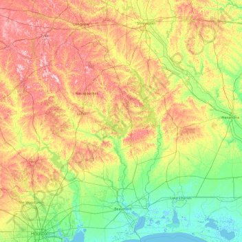
Name: Sabine River topographic map, elevation, terrain.
Location: Sabine River, United States (29.63888 -95.92007 32.80854 -93.50782)
Average elevation: 207 ft
Minimum elevation: -16 ft
Maximum elevation: 755 ft
United States trails, hiking, mountain biking, running and outdoor activities
Other topographic maps
Click on a map to view its topography, its elevation and its terrain.
Portland
United States > Oregon > Multnomah County
Portland features a striking and varied topography characterized by its location at the confluence of the Willamette and Columbia Rivers. The city lies within the fertile Willamette Valley, flanked by the snow-capped Cascade Mountains to the east, including the prominent Mount Hood, and the less elevated…
Average elevation: 253 ft
Oregon
Oregon's topography is strikingly diverse, characterized by an array of geographical features that shape its unique landscape. The state is framed by two significant mountain ranges: the Pacific Coast Range to the west and the Cascade Mountains running north to south through the center. This mountainous…
Average elevation: 3,077 ft
Seattle
United States > Washington > King County
Seattle features a diverse topography characterized by its unique geographical setting between Puget Sound and Lake Washington. The city is situated on an isthmus, which contributes to its dramatic landscape, featuring rolling hills and steep slopes that rise abruptly from the waterfront. The average elevation…
Average elevation: 131 ft
New York
New York City's topography is a fascinating blend of varied elevations and unique landscapes, reflecting its diverse geography across five boroughs. Situated at the confluence of the Hudson and East Rivers, the city primarily features low-lying terrain, with the average elevation hovering around sea level.…
Average elevation: 62 ft
Arizona
Arizona's topography is highly diverse, shaped by three distinct regions: the Colorado Plateau, the Basin and Range Province, and the Transition Zone. The northern Colorado Plateau is characterized by flat, high plains over 4,000 feet in elevation, including the Grand Canyon and its breathtaking cliffs. In…
Average elevation: 4,032 ft
San Francisco
San Francisco is characterized by its striking and varied topography, making it one of the most distinctive cities in the United States. The landscape features a mix of rolling hills and steep inclines, with the highest elevation reaching approximately 922 feet at Twin Peaks. The average elevation across the…
Average elevation: 207 ft
Gresham
United States > Oregon > Multnomah County
Though much of Gresham is relatively flat, it is characterized by a hill on its eastern border. Northeast Gresham is also hilly, particularly where the city meets Troutdale toward the Columbia River. Its elevation is 325 feet (99 m). Johnson Creek, which begins at the foothills of the Cascade Mountains, runs…
Average elevation: 295 ft
Salem
United States > Oregon > Marion County
Salem is situated in the heart of the Willamette Valley and features a varied topography shaped by its proximity to notable geological formations. The city itself is primarily located at an elevation of around 177 feet (54 meters), but it spans a range from approximately 120 to 800 feet (37 to 244 meters)…
Average elevation: 315 ft
California
California's topography is characterized by a remarkable diversity that includes expansive mountain ranges, deep valleys, and vast deserts. The Sierra Nevada mountains dominate the eastern part of the state, with peaks such as Mount Whitney rising to 14,494 feet, making it the tallest point in the contiguous…
Average elevation: 3,048 ft
Saint Petersburg
United States > Florida > Pinellas County
Saint Petersburg features a predominantly flat topography characteristic of the Gulf Coast region. The city's elevation averages around 44 feet (approximately 13.4 meters) above sea level, with some areas dipping to about 15 feet (4.6 meters). This relatively low elevation contributes to the area's…
Average elevation: 13 ft
Pittsburgh
United States > Pennsylvania > Allegheny County
Pittsburgh, located in Allegheny County, Pennsylvania, is characterized by its distinct and varied topography, shaped by the confluence of the Allegheny, Monongahela, and Ohio rivers. The city itself is situated at an average elevation of approximately 764 feet (233 meters) above sea level, with the terrain…
Average elevation: 994 ft
Denver
United States > Colorado > Denver County > Denver
Denver, situated at an elevation of 5,280 feet (1,609 meters), is renowned as the "Mile High City." It is located in the South Platte River Valley, just east of the Rocky Mountains' foothills. The city's topography features a gently sloping landscape characterized by rolling hills and wide valleys,…
Average elevation: 5,525 ft
Dallas
United States > Texas > Dallas County
Dallas features a predominantly flat terrain characterized by elevations generally ranging from 450 to 550 feet (137 to 168 meters) above sea level. The landscape is shaped significantly by the western edge of the Austin Chalk Formation, a limestone escarpment known as the White Rock Escarpment, which rises…
Average elevation: 525 ft
Florida
Florida's topography is characterized by its predominantly flat landscape, with the highest elevation being Britton Hill at just 345 feet above sea level, making it the lowest high point of any U.S. state. The state is primarily divided into three physiographic regions: the Atlantic Coastal Plain, the East…
Average elevation: 20 ft
Virginia
Virginia's topography is characterized by a diverse landscape that transitions from the Atlantic Coastal Plain in the east to the mountainous regions in the west. The Coastal Plain features flat, low-lying areas that gradually rise to the Piedmont, known for its rolling hills and valleys. Further west, the…
Average elevation: 814 ft
Lake Tahoe
United States > California > Placer County
Lake Tahoe is renowned for its dramatic topography, characterized by rugged mountain ranges and deep, crystal-clear waters. Nestled in the Sierra Nevada, the lake itself lies at an elevation of approximately 6,225 feet (1,897 meters) and spans about 22 miles (35 kilometers) in length and 12 miles (19…
Average elevation: 6,814 ft
Chicago
United States > Illinois > Cook County
Chicago is characterized by its predominantly flat terrain, with an average elevation of about 579 feet (176 meters) above sea level. The city's landscape is primarily shaped by its proximity to Lake Michigan to the east, which influences local weather and provides a scenic waterfront. While the central areas…
Average elevation: 597 ft
Austin
United States > Texas > Travis County
Austin features a diverse and varied topography shaped by its position along the Balcones Fault. The city’s elevation ranges from about 425 feet to approximately 1,000 feet above sea level, creating a landscape characterized by rolling hills and elevated areas particularly in the western regions. To the…
Average elevation: 709 ft
Atlanta
United States > Georgia > Fulton County
Atlanta features a varied topography characterized by its rolling hills and elevated terrain. The city sits at an average elevation of approximately 1,050 feet (320 meters) above sea level, with elevations ranging from about 725 feet (221 meters) to 1,175 feet (358 meters) in the surrounding areas. This…
Average elevation: 932 ft
Salt Lake City
United States > Utah > Salt Lake County
Salt Lake City's topography is characterized by a striking contrast between its flat valley floor and the surrounding rugged mountains. The city is situated in the Salt Lake Valley, with an average elevation of approximately 4,237 feet above sea level, making it one of the higher major cities in the United…
Average elevation: 5,223 ft
San Diego
United States > California > San Diego County
San Diego is characterized by a diverse topography that features coastal plains, rolling hills, and rugged mountain ranges. The city is situated along the Pacific Ocean, where it boasts an extensive shoreline with sandy beaches and tidal zones. As you move inland, the landscape transitions from the flat…
Average elevation: 410 ft
Eugene
United States > Oregon > Lane County
Eugene is characterized by a varied topography that contributes to its picturesque landscapes. The city sits at an average elevation of about 426 feet (130 meters) and is nestled within the Willamette Valley, surrounded by the foothills of the Cascade Mountains to the east, which rise significantly in…
Average elevation: 535 ft
Birmingham
United States > Alabama > Jefferson County
Birmingham has a varied and rugged topography shaped by the nearby Appalachian foothills. The city sits at an average elevation of around 600 feet (183 meters), though it is surrounded by more dramatic terrain that rises higher to 1,000 feet (305 meters) in some areas, particularly to the south and east.…
Average elevation: 633 ft
Puerto Rico
Puerto Rico features a diverse topography characterized by a mountainous interior, coastal plains, and stunning beaches. The island's central region is dominated by the Cordillera Central mountain range, which includes the highest peak, Cerro de Punta, rising to 4,390 feet (1,338 meters). These mountains…
Average elevation: 213 ft
Boston
United States > Massachusetts > Suffolk County
Boston features a diverse and dynamic topography that shapes its character. The city is primarily located on the Shawmut Peninsula and encompasses a mix of coastal plains and rolling hills. Its average elevation hovers around 85 feet, with the highest point being Bellevue Hill at approximately 330 feet. The…
Average elevation: 82 ft
Phoenix
United States > Arizona > Maricopa County
Phoenix is characterized by a unique topographical landscape nestled in the Salt River Valley. This valley, at an average elevation of about 1,086 feet, is framed by several prominent mountain ranges, creating a striking contrast between the flat plains and elevated terrains. Notable peaks such as Camelback…
Average elevation: 1,578 ft
Colorado
Colorado's topography is characterized by a diverse range of elevations and landforms, making it one of the most geologically varied states in the U.S. The state is dominated by the Rocky Mountains, which run north to south and include the highest peak in the contiguous United States, Mount Elbert, towering at…
Average elevation: 6,759 ft
Hillsboro
United States > Oregon > Washington County
Hillsboro is located at 45°31′N 122°59′W / 45.517°N 122.983°W / 45.517; -122.983 (Hillsboro, Oregon). The United States Census Bureau reports the city has a total area of 21.6 square miles (55.9 km2), all of which is land. In 2013, Hillsboro itself reported an area of 23.88 square miles…
Average elevation: 174 ft
Nashville-Davidson
United States > Tennessee > Davidson County
Nashville-Davidson, features a diverse topography characterized by its position in the Nashville Basin and the Highland Rim. The terrain is predominantly hilly, with elevations ranging from approximately 385 feet at the Cumberland River to around 1,163 feet in areas like Radnor Lake State Natural Area. This…
Average elevation: 604 ft
Kansas City
United States > Missouri > Jackson County
Kansas City features a diverse topography characterized by rolling hills and valleys, with elevations ranging from about 794 to 997 feet above sea level. The landscape is shaped by the confluence of the Missouri and Kansas rivers, resulting in a mix of elevated areas and flat river plains. The region's average…
Average elevation: 909 ft
Pennsylvania
Pennsylvania's topography is characterized by its rich diversity, ranging from the rugged Appalachian Mountains in the south to the flatlands of the northern plateau. The state's elevation varies significantly, with the highest point being Mount Davis at approximately 3,213 feet and the lowest at sea level…
Average elevation: 1,115 ft
Bellingham
United States > Washington > Whatcom County
Bellingham is characterized by a diverse and striking topography that combines coastal and mountainous landscapes. The city lies along the eastern shore of Bellingham Bay, where the waters of the Puget Sound meet the foothills of the Cascade Range. Rising abruptly from the shoreline, the surrounding hills and…
Average elevation: 292 ft
Scottsdale
United States > Arizona > Maricopa County
Scottsdale features a diverse topography shaped by its location within the Sonoran Desert and the foothills of the McDowell Mountains. The city sits at an average elevation of about 1,827 feet (558 meters), with a range that spans from approximately 1,052 feet (321 meters) at its lowest points to 4,819 feet…
Average elevation: 1,814 ft
Washington
Washington State's topography is characterized by dramatic contrasts, shaped primarily by the formidable Cascade Mountain Range that divides the state into distinct western and eastern regions. The western part is marked by rugged mountains, lush forests, and a plethora of lakes, resulting from glacial…
Average elevation: 2,612 ft
Ohio
Ohio's topography is characterized by a diverse landscape that ranges from the flat plains in the north to the rolling hills and rugged terrain in the southeast. The state can be divided into several distinct regions, including the Great Lakes Plains to the north, the Central Plains in the west, and the…
Average elevation: 912 ft
Minneapolis
United States > Minnesota > Hennepin County
Minneapolis is characterized by a diverse and dynamic topography. The city sits at an average elevation of approximately 830 feet (253 meters) above sea level, but this varies significantly across its landscape. The terrain is predominantly flat, interspersed with rolling hills, and is marked by the presence…
Average elevation: 886 ft
Texas
Texas showcases a diverse and expansive topography that spans approximately 268,000 square miles, making it the second-largest state in the United States. The landscape ranges from the arid deserts of West Texas, characterized by broad valleys and mesas, to the rolling hills of the Texas Hill Country, where…
Average elevation: 1,699 ft
Michigan
Michigan's topography is characterized by a diverse landscape that transitions from flat plains to rugged hills. The state comprises two peninsulas, with the Upper Peninsula showcasing more pronounced elevation changes, including its highest point, Mount Arvon, which rises to 1,979 feet (603 meters). In…
Average elevation: 850 ft
Wilmington
United States > North Carolina > New Hanover County
Wilmington sits near the southeastern coast and has a low-lying, relatively flat topography with an average elevation around 36 feet above sea level. The terrain is characterized by coastal plains with minimal elevation changes, making the landscape generally flat as it gently slopes toward the Atlantic Ocean.…
Average elevation: 23 ft
Tampa
United States > Florida > Hillsborough County
Tampa is characterized by a predominantly flat topography, with an average elevation around 16 to 49 feet above sea level. The terrain is marked by low-lying areas and gentle slopes, with the highest points in the vicinity reaching approximately 62 feet. This landscape is interspersed with numerous water…
Average elevation: 36 ft
Houston
United States > Texas > Harris County
Houston is characterized by its predominantly flat topography, sitting at an average elevation of approximately 59 feet (18 meters) above sea level. The city is situated on the Gulf Coastal Plain, which is dissected by a network of bayous that contribute to the region's drainage. This terrain was once covered…
Average elevation: 82 ft
Tulsa
United States > Oklahoma > Tulsa County
Tulsa, located in northeastern Oklahoma, is characterized by a diverse and rolling topography that marks its transition from the Great Plains to the Ozark foothills. The city's elevation averages around 700 feet (approximately 210 meters) above sea level, with some areas reaching heights of up to 1,050 feet…
Average elevation: 725 ft
Asheville
United States > North Carolina > Buncombe County
Asheville, located in Buncombe County, North Carolina, is characterized by a diverse and picturesque topography primarily shaped by its position within the Blue Ridge Mountains. The city itself sits at an elevation of approximately 2,200 feet, surrounded by peaks that rise significantly higher, such as Mount…
Average elevation: 2,385 ft
Reno
United States > Nevada > Washoe County
Reno is characterized by its diverse topography, which is shaped by its elevation and the surrounding mountain ranges. Situated at an average elevation of approximately 4,500 feet (about 1,370 meters), the city is nestled in a high desert region that features a mix of flat valleys and gently rolling hills.…
Average elevation: 5,413 ft
Anne Arundel County
Elevations in Anne Arundel County range from sea level at the Chesapeake and tidal tributaries to about 300 feet (91 m) in western areas near the fall line. The terrain is mostly flat or gently rolling, but more dramatic banks and bluffs can be found where waterways cut through areas of higher elevation.
Average elevation: 82 ft
Newberg
United States > Oregon > Yamhill County
According to the United States Census Bureau, the city has a total area of 5.81 square miles (15.05 km2), all of it land. It averages 176 feet (54 m) in elevation.
Average elevation: 200 ft
Tucson
United States > Arizona > Pima County
Tucson is situated on an alluvial plain in the Sonoran Desert, at an elevation of approximately 2,400 feet (730 meters) above sea level. The city is enveloped by five mountain ranges, which contribute significantly to its varied topography. To the north lie the Santa Catalina and Tortolita Mountains, while the…
Average elevation: 2,697 ft
Snoqualmie Pass
United States > Washington > King County
Due to its elevation, Snoqualmie Pass experiences significantly lower temperatures than Seattle, and receives much more precipitation, much of it being snow. Snoqualmie Pass has a humid continental climate (Koppen: Dsb bordering Csb) with cold, very wet and snowy winters, and mild to warm, relatively dry…
Average elevation: 3,438 ft
Oklahoma
Oklahoma features a diverse and complex topography characterized by its mixture of plains, plateaus, and mountainous regions. The state is divided into distinct physiographic regions, including the flat Prairie Plains that dominate much of the northern and central areas, and the rugged Ozark Plateau in the…
Average elevation: 1,339 ft
Manhattan
United States > New York > New York County > New York
Manhattan, a densely populated urban island, has a diverse topography characterized by its generally flat terrain interspersed with elevated areas. The average elevation is about 50 feet (15 meters) above sea level, with its highest point reaching approximately 265 feet (81 meters) at Bennett Park in…
Average elevation: 52 ft
New Jersey
New Jersey's topography is characterized by a diverse landscape that ranges from coastal plains to rolling hills and rugged mountains. The state features a predominantly low elevation along its eastern coastline, where major cities like Newark and Jersey City are located. This coastal lowland, which includes…
Average elevation: 236 ft
Oakland
United States > California > Alameda County
Oakland features a diverse topography shaped by its location along the eastern shore of San Francisco Bay and the presence of the nearby coastal hills. The city sits on a flat coastal plain that gradually ascends toward the Oakland Hills to the east, where elevations can exceed 1,700 feet. The highest point…
Average elevation: 167 ft
San Antonio
United States > Texas > Bexar County
San Antonio features a diverse topography characterized by gently rolling hills and flat plains. The city's elevation averages around 650 feet above sea level, but nearby areas can reach heights of up to 1,300 feet in certain locations like Cross Mountain. The landscape is part of the southern edge of the…
Average elevation: 810 ft
Alexandria
Alexandria, Virginia, is characterized by a diverse topography that features both flat and gently rolling landscapes, primarily situated along the banks of the Potomac River. The city sits at an average elevation of about 100 feet above sea level, with some areas dipping to nearly 5 feet below sea level near…
Average elevation: 75 ft
Albany
United States > Oregon > Linn County
According to the United States Census Bureau, the city has a total area of 17.75 square miles (45.97 km2), of which 17.54 square miles (45.43 km2) is land and 0.21 square miles (0.54 km2) is water. Albany has 21.7 square miles (56 km2) within its urban growth boundary. Throughout the city limits and urban…
Average elevation: 233 ft
Missouri
Missouri's topography is marked by a diverse array of landforms that contribute to its unique landscape. The state is characterized by four main physiographic regions: the Ozark Plateau, Dissected Till Plains, Mississippi Alluvial Plain, and the Osage Plains. The Ozark Plateau, located in the south, features…
Average elevation: 827 ft
Bend
United States > Oregon > Deschutes County
Bend is characterized by its distinctive topography, situated at an elevation of approximately 3,623 feet (1,105 meters) above sea level. The city lies within the high desert region of Central Oregon, bordered by the Cascade Mountains to the west, which provide a dramatic backdrop with peaks like the Three…
Average elevation: 3,678 ft
Beaverton
United States > Oregon > Washington County
As of January 2020, Beaverton covers a total area of 19.7 square miles (51 km2), all of it land except for small creeks, ponds, and lakes. The city is located along the eastern edge of the Tualatin Valley just west of the Tualatin Mountains. It is bordered by Portland to the east, Hillsboro to the west, and…
Average elevation: 348 ft
Saint Croix
United States > United States Virgin Islands > Saint Croix District > Christiansted
Average elevation: 36 ft
Boone
United States > North Carolina > Watauga County
Boone, located in Watauga County, North Carolina, is set within the rugged Appalachian Mountains, specifically the Blue Ridge range. With an elevation of approximately 3,300 feet (1,016 meters), it stands as one of the highest towns of its size in the eastern United States. The terrain is dominated by steep…
Average elevation: 3,507 ft
Ann Arbor
United States > Michigan > Washtenaw County
Ann Arbor features a varied topography characterized by rolling hills and valleys shaped by glacial activity. The city is situated along the Huron River, which carves its way through the landscape, creating steep banks and fertile floodplains. Elevations range from approximately 750 feet (230 meters) along the…
Average elevation: 879 ft
New Mexico
New Mexico's topography is strikingly diverse, characterized by a mix of high mountain ranges, arid plains, and expansive desert regions. The state is primarily defined by the Rocky Mountains, which run north to south through its central region, featuring peaks that reach over 13,000 feet, such as Wheeler…
Average elevation: 5,535 ft
Illinois
Illinois features a diverse topography characterized primarily by broad, fertile plains and some hilly regions. The state is predominantly flat, with about 90% covered by the Central Plains, particularly the Till Plains, which are rich agricultural lands shaped by glacial activity during the last Ice Age. The…
Average elevation: 699 ft
Pensacola
United States > Florida > Escambia County
Pensacola features a diverse topography characterized primarily by its proximity to the Gulf of Mexico and the sheltered Pensacola Bay. The terrain gently slopes upward from the waterfront, resulting in a gradual elevation that provides natural protection against storm surges, making it somewhat less…
Average elevation: 69 ft
Chattanooga
United States > Tennessee > Hamilton County
Chattanooga showcases a diverse and striking topography that is defined by its position within the Appalachian region. Nestled between the rugged Ridge-and-Valley Appalachians and the Cumberland Plateau, the city is framed by dramatic hills and valleys, creating a visually compelling landscape. The Tennessee…
Average elevation: 1,086 ft
Fort Myers
United States > Florida > Lee County
Fort Myers, located in Lee County, Florida, features a predominantly flat topography characterized by low elevations, averaging around 10 to 16 feet (approximately 3 to 5 meters) above sea level. The area is primarily composed of coastal plains, which contribute to its lush, subtropical vegetation and…
Average elevation: 16 ft
Buffalo
United States > New York > Erie County
Buffalo is characterized by its relatively flat terrain, predominantly lying on the Erie/Ontario Lake Plain, which forms part of the Eastern Great Lakes Lowlands. The city's elevation averages around 607 feet above sea level, with minor variations, particularly in neighborhoods like University Heights, which…
Average elevation: 607 ft
Savannah
United States > Georgia > Chatham County
Savannah is characterized by a unique and varied topography shaped by its coastal location and historical development. The city is situated on a series of low bluffs along the Savannah River, which flows into the Atlantic Ocean approximately 18 miles (29 km) away. The terrain features a mix of flat coastal…
Average elevation: 13 ft
Fort Collins
United States > Colorado > Larimer County
Fort Collins is situated at an elevation of approximately 5,003 feet (1,524 meters) above sea level, nestled at the base of the Rocky Mountains in northern Colorado. The city features a varied topography characterized by gently rolling plains that gradually rise to foothills, creating a picturesque backdrop.…
Average elevation: 5,079 ft
North Carolina
North Carolina features a diverse topography that can be divided into three distinct regions: the Coastal Plain, the Piedmont, and the Appalachian Mountains. The Coastal Plain, which occupies the eastern part of the state, is characterized by flat and gently sloping land, with elevations typically less than…
Average elevation: 535 ft
Charlotte
United States > North Carolina > Mecklenburg County
Charlotte, located in the Piedmont region of North Carolina, features a gently rolling terrain characterized by elevations ranging from approximately 650 to 700 feet (198 to 213 meters). The city is bordered to the west by the Catawba River, which contributes to the area's mild climate and lush vegetation.…
Average elevation: 679 ft
Oklahoma City
United States > Oklahoma > Oklahoma County
Oklahoma City is situated in a region characterized by diverse topography that reflects the broader geographical features of the state. The terrain predominantly consists of gently rolling plains, which gradually rise in elevation toward the west, where the land transitions into the rugged Arbuckle Mountains.…
Average elevation: 1,188 ft
San Francisco Bay Area
United States > California > San Francisco
The San Francisco Bay Area is characterized by a diverse and dynamic topography shaped by geological processes over millions of years. This region features a combination of coastal plains, steep hills, and rugged mountains, all influenced by the tectonic activity associated with the nearby San Andreas Fault…
Average elevation: 371 ft
Maui
United States > Hawaii > Maui County
Maui County's topography is characterized by a dramatic blend of volcanic mountains, rolling hills, and stunning coastal regions, creating a diverse landscape that contributes to its unique beauty. The island's centerpiece is Haleakalā, a massive shield volcano rising to an elevation of 10,023 feet, which is…
Average elevation: 761 ft
Philadelphia
United States > Pennsylvania > Philadelphia County
Philadelphia, located at the confluence of the Delaware and Schuylkill Rivers, features a diverse topography characterized by its gentle slopes and valleys. The city lies on the Atlantic Seaboard Fall Line, transitioning from the flat Coastal Plain to the more rugged Piedmont region. This unique geographical…
Average elevation: 144 ft
Colorado Springs
United States > Colorado > El Paso County
Colorado Springs boasts a diverse and striking topography characterized by its high elevation and mountainous terrain. Nestled at approximately 6,035 feet (1,839 meters) above sea level, the city is flanked by the majestic Pikes Peak, which rises dramatically to 14,115 feet (4,302 meters), forming part of the…
Average elevation: 7,388 ft
Lynchburg
Lynchburg has a four-season humid subtropical climate (Köppen Cfa), with cool winters and hot, humid summers. The monthly daily average temperature ranges from 35.9 °F (2.2 °C) in January to 76.0 °F (24.4 °C) in July. Nights tend to be significantly cooler than days throughout much of the year due in part…
Average elevation: 751 ft
Scranton
United States > Pennsylvania > Lackawanna County
Center City is about 750 feet (229 m) above sea level, although the hilly city's inhabited portions range about from 650 to 1,400 feet (200 to 430 m). The city is flanked by mountains to the east and west whose elevations range from 1,900 to 2,100 feet (580 to 640 m).
Average elevation: 1,181 ft
Hood River
United States > Oregon > Hood River County
Temperatures for the year as a whole are slightly cooler than in most other low-elevation towns in the region, especially at night because of air drainage off the surrounding mountains.
Average elevation: 367 ft
Cape Coral
United States > Florida > Lee County
Cape Coral is characterized by its predominantly flat and low-lying terrain, with an average elevation of around 13 feet (4 meters) above sea level. The area's topography features a network of canals, with over 400 miles of navigable waterways, making it one of the most waterway-dense cities globally. The…
Average elevation: 13 ft
Tennessee
Tennessee features a diverse and varied topography characterized by its distinct regions, which include the Appalachian Mountains, the Central Basin, and the Gulf Coastal Plain. The state’s highest point is Clingmans Dome, rising to about 6,643 feet above sea level, while the lowest point is along the…
Average elevation: 764 ft