
Orange County topographic map
Interactive map
Click on the map to display elevation.
Orange County
According to the U.S. Census Bureau, the county has a total area of 343 square miles (890 km2), of which 341 square miles (880 km2) is land and 2.5 square miles (6.5 km2) (0.7%) is water. The terrain is characterized by rolling hills, generally increasing in altitude and slope as they continue westward toward the Blue Ridge Mountains. The highest point is Cowherd Mountain at 1,196 ft (345 m), approximately 2.5 miles (4 km) northwest of Gordonsville.
About this map
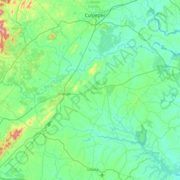
Name: Orange County topographic map, elevation, terrain.
Location: Orange County, Virginia, United States (38.11799 -78.36878 38.39306 -77.70284)
Average elevation: 436 ft
Minimum elevation: 177 ft
Maximum elevation: 2,073 ft
Virginia trails, hiking, mountain biking, running and outdoor activities
Other topographic maps
Click on a map to view its topography, its elevation and its terrain.
Virginia Beach
United States > Virginia > Virginia Beach
Virginia Beach, Virginia, located in the coastal region of the United States, features a predominantly flat terrain characterized by its proximity to the Atlantic Ocean. The elevation is remarkably low, averaging about 10 feet (3 meters) above sea level, which contributes to the area's susceptibility to…
Average elevation: 7 ft
Wattsville
United States > Virginia > Accomack County
It lies at an elevation of 3 feet.
Average elevation: 36 ft
Thousand Trails Chesapeake Bay RV Resort
United States > Virginia > Gloucester County
Average elevation: 33 ft
Rustburg
United States > Virginia > Campbell County
Rustburg is located in north-central Campbell County at 37°16′25″N 79°05′56″W / 37.273731°N 79.098914°W / 37.273731; -79.098914 (37.273731, −79.098914). U.S. Route 501 passes through the center of town, leading north 11 miles (18 km) to Lynchburg and south 20 miles (32 km) to Brookneal.…
Average elevation: 892 ft
Quinby
United States > Virginia > Accomack County
It lies at an elevation of 7 feet.
Average elevation: 3 ft
Kiptopeke State Park
United States > Virginia > Northampton County > Kiptopeke
Average elevation: 20 ft
Robious Landing Park
United States > Virginia > Chesterfield County > Midlothian
Average elevation: 180 ft