
Clay County topographic map
Interactive map
Click on the map to display elevation.
About this map
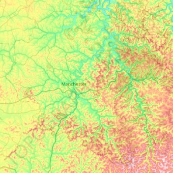
Name: Clay County topographic map, elevation, terrain.
Location: Clay County, Kentucky, United States (36.93767 -83.96957 37.35811 -83.50511)
Average elevation: 1,237 ft
Minimum elevation: 699 ft
Maximum elevation: 2,169 ft
Kentucky trails, hiking, mountain biking, running and outdoor activities
Other topographic maps
Click on a map to view its topography, its elevation and its terrain.
Pleasure Ridge Park
United States > Kentucky > Jefferson County > Louisville
Average elevation: 466 ft
Mammoth Cave National Park
United States > Kentucky > Edmonson County > Brownsville
The upper sandstone member is known as the Big Clifty Sandstone. Thin, sparse layers of limestone interspersed within the sandstone give rise to an epikarstic zone, in which tiny conduits (cave passages too small to enter) are dissolved by the natural acidity of groundwater. The epikarstic zone concentrates…
Average elevation: 705 ft