
Belluno topographic map
Click on the map to display elevation.
Belluno
The national park includes mountain ranges of Alpi Feltrine (Vette di Feltre, Cimonega, Pizzocco, Brendol, Agnelezze), Monti del Sole, Schiara, Talvena, Prampèr, and Spiz di Mezzodì. There are high-altitude areas, karst rocks, and debris slopes, ideal habitat for high-mountain species.
About this map
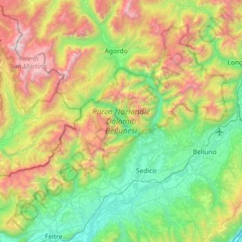
Name: Belluno topographic map, elevation, terrain.
Location: Belluno, Veneto, Italy, Parco Nazionale Dolomiti Bellunesi (46.04338 11.76610 46.31945 12.26498)
Average elevation: 3,678 ft
Minimum elevation: 518 ft
Maximum elevation: 10,436 ft
Other topographic maps
Click on a map to view its topography, its elevation and its terrain.
Tai di Cadore
Italy > Veneto > Belluno > Pieve di Cadore > Pieve di Cadore
Average elevation: 3,074 ft
Semonzo del Grappa
Italy > Veneto > Province of Treviso > Borso del Grappa
Average elevation: 1,119 ft
Cascina Norbiato
Italy > Veneto > Province of Padua > Villafranca Padovana > Taggì di Sotto
Average elevation: 56 ft
Tre Cime di Lavaredo - Drei Zinnen
Italy > Veneto > Belluno > Auronzo di Cadore
Until 1919 the peaks formed part of the border between Italy and Austria-Hungary. Now they lie on the border between the Italian provinces of South Tyrol and Belluno and still are a part of the linguistic boundary between German-speaking and Italian-speaking majorities. The Cima Grande has an elevation of…
Average elevation: 7,356 ft
Torretta delle province VI BL TV
Italy > Veneto > Belluno > Seren del Grappa
Average elevation: 4,879 ft
Cortina d'Ampezzo
Italy > Veneto > Belluno > Cortina d'Ampezzo > Cortina d'Ampezzo
Among the surrounding mountains are Tofane to the west, Pomagagnon to the north, Cristallo to the northeast, Faloria and Sorapiss to the east, and Becco di Mezzodì, Croda da Lago and Cinque Torri to the south. Monte Antelao (Nantelou in Ladin) is at 3264 m the highest mountain in the Ampezzo Dolomites and the…
Average elevation: 5,410 ft
Monte Pastello
Italy > Veneto > Verona > Fumane
Monte Pastello is a mountain of the Veneto, Italy. The mountain, which has an elevation of 1,128 metres, is part of the Monti Lessini in the Venetian Prealps. It is located in the Province of Verona.
Average elevation: 2,290 ft
Tre Cime di Lavaredo - Drei Zinnen
Italy > Veneto > Belluno > Auronzo di Cadore
Until 1919 the peaks formed part of the border between Italy and Austria-Hungary. Now they lie on the border between the Italian provinces of South Tyrol and Belluno and still are a part of the linguistic boundary between German-speaking and Italian-speaking majorities. The Cima Grande has an elevation of…
Average elevation: 7,356 ft
Sas de Stria
Italy > Veneto > Belluno > Cortina d'Ampezzo
Sass de Stria is a mountain of the Veneto, Italy. It has an elevation of 2,477 meters. During the First World War, the mountain and surrounding area was the scene of fighting between Italy and Austria-Hungary.
Average elevation: 7,014 ft
Monte Cengio
Italy > Veneto > Vicenza > Cogollo del Cengio
Monte Cengio is a mountain in the Asiago plateau, within the Vicentine Alps, in Veneto, northeastern Italy. It has an elevation of 1,354 metres and is located on the southwestern edge of the plateau, in the territory of Cogollo del Cengio.
Average elevation: 3,068 ft