
马鸣乡 topographic map
Interactive map
Click on the map to display elevation.
About this map
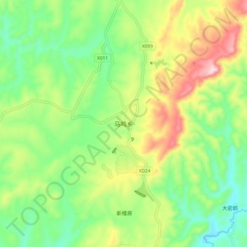
Name: 马鸣乡 topographic map, elevation, terrain.
Location: 马鸣乡, 马龙区, 曲靖市, 云南省, 中国 (25.23280 103.33672 25.31280 103.41672)
Average elevation: 6,581 ft
Minimum elevation: 6,165 ft
Maximum elevation: 7,264 ft
Other topographic maps
Click on a map to view its topography, its elevation and its terrain.
西双版纳热带植物园-百竹园
西双版纳热带植物园-百竹园, 勐仑镇, 勐腊县, 西双版纳傣族自治州, 云南省, 666100, 中国
Average elevation: 1,834 ft