Geolocate

Broad Run topographic map

Click on the map to display elevation.

About this map

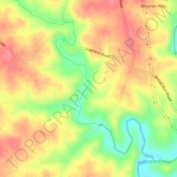
Name: Broad Run topographic map, elevation, terrain.

Location: Broad Run, Frederick County, Maryland, 21755, United States (39.36111 -77.59947 39.38330 -77.57616)

Average elevation: 433 ft

Minimum elevation: 282 ft

Maximum elevation: 538 ft

Maryland trails, hiking, mountain biking, running and outdoor activities

Other topographic maps

Click on a map to view its topography, its elevation and its terrain.

Baltimore

United States > Maryland

Baltimore exhibits a diverse topography that plays a significant role in its character and development. Situated along the Patapsco River, which flows into the Chesapeake Bay, the city is positioned on the fall line that separates the Piedmont Plateau to the west from the Atlantic Coastal Plain to the east.…

Average elevation: 213 ft

Chesapeake Bay

United States > Maryland

Tides in the Chesapeake Bay exhibit an interesting and unique behavior due to the nature of the topography (both horizontal and vertical shape), wind-driven circulation, and how the Bay interacts with oceanic tides. Research into the peculiar behavior of tides both at the northern and southern extents of the…

Average elevation: 108 ft

Worcester County

United States > Maryland

The terrain is mostly level and coastal. The lowest elevation is sea level along the Atlantic Ocean and the highest elevation is 49 ft (15 m) in the northwestern part of the county along State Route 12 just south of the Wicomico County line.

Average elevation: 20 ft

Ocean Pines

United States > Maryland > Worcester County

Average elevation: 10 ft

Perry Hall

United States > Maryland > Baltimore County

Average elevation: 236 ft

Chestertown

United States > Maryland > Kent County

Average elevation: 36 ft

Ellicott City

United States > Maryland > Howard County

Average elevation: 390 ft

Perryville

United States > Maryland > Cecil County

Average elevation: 151 ft

Anne Arundel County

United States > Maryland

Average elevation: 10 ft

Kent County

United States > Maryland

Average elevation: 33 ft

Somerset County

United States > Maryland

Average elevation: 7 ft

Whitehall

United States > Maryland > Dorchester County

Average elevation: 13 ft

Deep Creek Lake

United States > Maryland > Garrett County > McHenry

Average elevation: 2,602 ft

Keedysville

United States > Maryland > Washington County

Average elevation: 423 ft

Derwood

United States > Maryland > Montgomery County

Average elevation: 436 ft

Bethesda

United States > Maryland > Bethesda

Average elevation: 282 ft

Antietam

United States > Maryland > Washington County

Average elevation: 404 ft

Ocean City

United States > Maryland > Ocean City

Average elevation: 3 ft

Brooklandville

United States > Maryland > Baltimore County > Towson

Average elevation: 400 ft

Pinto

United States > Maryland > Allegany County > Bel Air

Average elevation: 810 ft

Woodland

United States > Maryland > Allegany County

Average elevation: 1,962 ft

Zihlman

United States > Maryland > Allegany County

Zihlman is located along Maryland Route 36, 1.5 miles (2.4 km) northeast of and 500 feet (150 m) lower in elevation than Frostburg. Mount Savage is 3 miles (5 km) further northeast along MD 36.

Average elevation: 1,936 ft

Amcelle

United States > Maryland > Allegany County > Potomac Park

Average elevation: 955 ft

McKenzie

United States > Maryland > Allegany County

Average elevation: 915 ft

Vale Summit

United States > Maryland > Allegany County

Average elevation: 2,149 ft

Spring Gap

United States > Maryland > Allegany County

Average elevation: 715 ft

Pleasant Grove

United States > Maryland > Allegany County

Average elevation: 1,047 ft

Potomac Park

United States > Maryland > Allegany County

Average elevation: 948 ft

Shaft

United States > Maryland > Allegany County > Borden Shaft > Braddock Estates

Shaft is a census-designated place (CDP) corresponding to the unincorporated community of Borden Shaft in Allegany County, Maryland, United States. As of the 2010 census, the CDP had a population of 235. It is located south of Frostburg, in the Georges Creek Valley. It lies at an elevation of 1,795 feet (547…

Average elevation: 1,929 ft

Ocean

United States > Maryland > Allegany County

Average elevation: 1,946 ft

Oldtown

United States > Maryland > Allegany County

Average elevation: 636 ft

Patterson Park

United States > Maryland > Baltimore

Average elevation: 56 ft

Nikep

United States > Maryland > Allegany County

Average elevation: 1,841 ft

National

United States > Maryland > Allegany County

Average elevation: 1,949 ft

Copper Oaks

United States > Maryland > Frederick County > Woodsboro

Average elevation: 433 ft

Woodsboro

United States > Maryland > Frederick County

Average elevation: 404 ft

Fort Meade

United States > Maryland > Anne Arundel County

Average elevation: 177 ft

Moscow

United States > Maryland > Allegany County

Average elevation: 1,785 ft

Midlothian

United States > Maryland > Allegany County

Average elevation: 2,093 ft

Dunkirk South

United States > Maryland > Calvert County > Dunkirk

Average elevation: 92 ft

McCoole

United States > Maryland > Allegany County

Average elevation: 945 ft

Melrose

United States > Maryland > Carroll County

Average elevation: 860 ft

Grahamtown

United States > Maryland > Allegany County

Average elevation: 1,972 ft

Klondike

United States > Maryland > Allegany County

Average elevation: 2,060 ft

Gilmore

United States > Maryland > Allegany County

Average elevation: 1,972 ft

Franklin

United States > Maryland > Allegany County

Average elevation: 1,486 ft

Detmold

United States > Maryland > Allegany County

Average elevation: 1,893 ft

Eckhart Mines

United States > Maryland > Allegany County

Average elevation: 1,880 ft

Ellerslie

United States > Maryland > Allegany County

Average elevation: 1,079 ft

Dawson

United States > Maryland > Allegany County

Average elevation: 1,063 ft

Corriganville

United States > Maryland > Allegany County

Average elevation: 1,073 ft

Cresaptown

United States > Maryland > Allegany County

Average elevation: 846 ft

Danville

United States > Maryland > Allegany County

Average elevation: 1,168 ft

Clarysville

United States > Maryland > Allegany County

Average elevation: 1,946 ft

Carlos

United States > Maryland > Allegany County

Average elevation: 2,083 ft

Bowling Green

United States > Maryland > Allegany County

Average elevation: 984 ft

Bowmans Addition

United States > Maryland > Allegany County

Average elevation: 1,132 ft

Bier

United States > Maryland > Allegany County

Average elevation: 938 ft

Bel Air

United States > Maryland > Allegany County

Average elevation: 863 ft

Midland

United States > Maryland > Allegany County

Average elevation: 1,870 ft

Barrelville

United States > Maryland > Allegany County

Average elevation: 1,437 ft

Luke

United States > Maryland > Allegany County

Average elevation: 1,316 ft

Barton

United States > Maryland > Allegany County

Average elevation: 1,585 ft

Aspen Hill

United States > Maryland > Montgomery County

Average elevation: 374 ft

Marion

United States > Maryland > Somerset County

Average elevation: 7 ft

Colesville

United States > Maryland > Montgomery County

Average elevation: 384 ft

Cascade

United States > Maryland > Washington County

Average elevation: 1,430 ft

Hampton

United States > Maryland > Baltimore County

Average elevation: 387 ft

Eden

United States > Maryland > Somerset County

Average elevation: 26 ft

Deerfield

United States > Maryland > Montgomery County > Potomac

Average elevation: 276 ft

Overlea

United States > Maryland > Baltimore County

Average elevation: 210 ft

Mountain Lake Park

United States > Maryland > Garrett County

Average elevation: 2,457 ft

Cloverly

United States > Maryland > Montgomery County

Average elevation: 456 ft

Bartonsville

United States > Maryland > Frederick County

Average elevation: 387 ft

Ilchester

United States > Maryland > Howard County

Average elevation: 351 ft

Williamsport

United States > Maryland > Washington County

Average elevation: 417 ft

Ridgely

United States > Maryland > Caroline County

Average elevation: 59 ft

Indian Head

United States > Maryland > Charles County

Average elevation: 39 ft

Fallston

United States > Maryland > Harford County

Average elevation: 417 ft

Glenmont

United States > Maryland > Montgomery County

Average elevation: 358 ft

Gear up for your next adventure:

🕶️Glacier Sunglasses - Side shields to protect eyes from high-altitude snow glare
🦟Ultrasonic Repellers - Create a bug-free zone at your camp or rest stop
🔦Powerful Headlamps - Ultra-bright hands-free lighting for night navigation
🗃️Trail First Aid Kit - Essential kit for outdoor injuries and emergencies
🪶Paracord Bracelet - Survival bracelet with built‑in tools

As an Amazon Associate, this site earns from qualifying purchases at no extra cost to you.