
岑巩县 topographic map
Interactive map
Click on the map to display elevation.
About this map
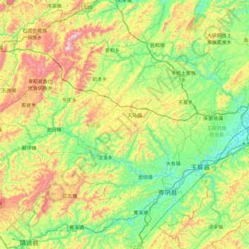
Name: 岑巩县 topographic map, elevation, terrain.
Location: 岑巩县, 黔东南苗族侗族自治州, 贵州省, 中国 (27.15861 108.33701 27.52740 109.03159)
Average elevation: 2,277 ft
Minimum elevation: 1,079 ft
Maximum elevation: 5,046 ft
Other topographic maps
Click on a map to view its topography, its elevation and its terrain.