
Macdona topographic map
Interactive map
Click on the map to display elevation.
About this map
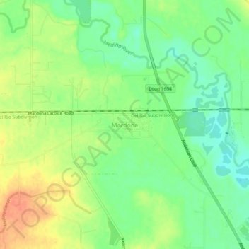
Name: Macdona topographic map, elevation, terrain.
Location: Macdona, Bexar County, Texas, 78054, United States (29.30546 -98.71519 29.34546 -98.67519)
Average elevation: 636 ft
Minimum elevation: 571 ft
Maximum elevation: 712 ft
Other topographic maps
Click on a map to view its topography, its elevation and its terrain.
San Antonio
United States > Texas > Bexar County
San Antonio, Bexar County, Texas, United States
Average elevation: 810 ft
San Pedro Springs Park
United States > Texas > Bexar County > San Antonio
San Pedro Springs Park, 2200, San Antonio, Bexar County, Texas, 78212, United States
Average elevation: 702 ft
Olmos Basin Park
United States > Texas > Bexar County > San Antonio
Olmos Basin Park, 651, San Antonio, Bexar County, Texas, 78209, United States
Average elevation: 751 ft
San Antonio
United States > Texas > Bexar County > San Antonio
San Antonio, Bexar County, Texas, 78205, United States
Average elevation: 715 ft
Cross Mountain
United States > Texas > Bexar County
Cross Mountain, Bexar County, Texas, 78255, United States
Average elevation: 1,309 ft
Shavano Park
United States > Texas > Bexar County
Shavano Park, Bexar County, Texas, United States
Average elevation: 961 ft
Elmendorf
United States > Texas > Bexar County
Elmendorf, Bexar County, Texas, United States
Average elevation: 502 ft
Live Oak
United States > Texas > Bexar County
Live Oak, Bexar County, Texas, United States
Average elevation: 860 ft
Leon Valley
United States > Texas > Bexar County
Leon Valley, Bexar County, Texas, United States
Average elevation: 853 ft
Balcones Heights
United States > Texas > Bexar County
Balcones Heights, Bexar County, Texas, United States
Average elevation: 863 ft
Sayers
United States > Texas > Bexar County
Sayers, Bexar County, Texas, 78263, United States
Average elevation: 564 ft
Olmos Park
United States > Texas > Bexar County
Olmos Park, Bexar County, Texas, United States
Average elevation: 751 ft
Somerset
United States > Texas > Bexar County
Somerset, Bexar County, Texas, United States
Average elevation: 630 ft
China Grove
United States > Texas > Bexar County
China Grove, Bexar County, Texas, United States
Average elevation: 646 ft
Sandy Oaks
United States > Texas > Bexar County
Sandy Oaks, Bexar County, Texas, United States
Average elevation: 607 ft
Saint Hedwig
United States > Texas > Bexar County
Saint Hedwig, Bexar County, Texas, 78152, United States
Average elevation: 568 ft
Castle Hills
United States > Texas > Bexar County
Castle Hills, Bexar County, Texas, 78213, United States
Average elevation: 843 ft
Von Ormy
United States > Texas > Bexar County
Von Ormy, Bexar County, Texas, United States
Average elevation: 597 ft
Atascosa
United States > Texas > Bexar County
Atascosa, Bexar County, Texas, 78002, United States
Average elevation: 666 ft
Hollywood Park
United States > Texas > Bexar County
Hollywood Park, Bexar County, Texas, United States
Average elevation: 945 ft
River Walk
United States > Texas > Bexar County > San Antonio
River Walk, Downtown, San Antonio, Bexar County, Texas, United States
Average elevation: 666 ft
Selma
United States > Texas > Bexar County
Selma, Bexar County, Texas, United States
Average elevation: 781 ft
Grey Forest
United States > Texas > Bexar County
Grey Forest, Bexar County, Texas, United States
Average elevation: 1,234 ft
Government Canyon State Natural Area
United States > Texas > Bexar County > San Antonio
Government Canyon State Natural Area, 12861, Galm Road, San Antonio, Bexar County, Texas, 78254, United States
Average elevation: 1,171 ft
Tom Slick Park
United States > Texas > Bexar County > San Antonio
Tom Slick Park, San Antonio, Bexar County, Texas, United States
Average elevation: 751 ft
Eisenhower Park
United States > Texas > Bexar County > San Antonio
Eisenhower Park, San Antonio, Bexar County, Texas, 78257, United States
Average elevation: 1,132 ft
Helotes
United States > Texas > Bexar County
Helotes, Bexar County, Texas, 78023, United States
Average elevation: 1,079 ft
Hill Country Village
United States > Texas > Bexar County
Hill Country Village, Bexar County, Texas, United States
Average elevation: 915 ft
Terrell Hills
United States > Texas > Bexar County
Terrell Hills, Bexar County, Texas, United States
Average elevation: 764 ft
Alamo Heights
United States > Texas > Bexar County
Alamo Heights, Bexar County, Texas, United States
Average elevation: 761 ft
Universal City
United States > Texas > Bexar County
Universal City, Bexar County, Texas, 78148, United States
Average elevation: 764 ft
Leon Creek
United States > Texas > Bexar County > San Antonio
Leon Creek, Leon Springs, San Antonio, Bexar County, Texas, 78257, United States
Average elevation: 1,184 ft
Travis Park
United States > Texas > Bexar County > San Antonio
Travis Park, Downtown, San Antonio, Bexar County, Texas, United States
Average elevation: 669 ft
Kirby
United States > Texas > Bexar County
Kirby, Bexar County, Texas, United States
Average elevation: 702 ft
Hardberger Park
United States > Texas > Bexar County > San Antonio
Hardberger Park, San Antonio, Bexar County, Texas, 78216, United States
Average elevation: 889 ft
Windcrest
United States > Texas > Bexar County
Windcrest, Bexar County, Texas, United States
Average elevation: 787 ft
Farias Park
United States > Texas > Bexar County > San Antonio
Farias Park, San Antonio, Bexar County, Texas, 78207, United States
Average elevation: 676 ft
Converse
United States > Texas > Bexar County
Converse, Bexar County, Texas, 78109, United States
Average elevation: 732 ft
Converse
United States > Texas > Bexar County > Converse > Converse
Converse, Bexar County, Texas, 78109, United States
Average elevation: 755 ft
Adkins
United States > Texas > Bexar County
Adkins, Bexar County, Texas, 78101, United States
Average elevation: 571 ft